TopoQuest Logo
Do you find TopoQuest useful?
Help keep TopoQuest running and adding new maps/features by donating!
Bitcoin:  19c7KJd3qBynnjoSw5npx9KScwjBe4ifkT
Litecoin:  LXs6TkuXGGXo1vDsWCkWVdjQX94eUKd6ui
Home View Maps Find Maps Find Places Resources & Links


Ornbaun Valley, California Topographic Map

USGS Map Title: Ornbaun Valley, CA
USGS Map MRC: 38123H3
DRG (GeoTIFF) Download: o38123h3.tif


Neighboring USGS Topographic Map Quads:


  Philo, CA  
39123A4
 

  Boonville, CA  
39123A3
 

  Elledge Peak, CA  
39123A2
 

  Zeni Ridge, CA  
38123H4
 

  Ornbaun Valley, CA  
38123H3
 

  Yorkville, CA  
38123H2
 

  McGuire Ridge, CA  
38123G4
 

  Gube Mountain, CA  
38123G3
 

  Big Foot Mountain, CA  
38123G2


Map MRC Location:

N39°
W124°
N39°
W123°
H8 H7 H6 H5 H4 H3 H2 H1
G8 G7 G6 G5 G4 G3 G2 G1
F8 F7 F6 F5 F4 F3 F2 F1
E8 E7 E6 E5 E4 E3 E2 E1
D8 D7 D6 D5 D4 D3 D2 D1
C8 C7 C6 C5 C4 C3 C2 C1
B8 B7 B6 B5 B4 B3 B2 B1
A8 A7 A6 A5 A4 A3 A2 A1
N38°
W124°
N38°
W123°

Ornbaun Valley, CA USGS 1:24K Topographic Map Preview:
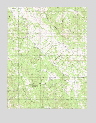
Ornbaun Valley, CA USGS Topographic Map
Click on map above to begin viewing in our Map Viewer.

This topographic map contains these locations and features:
Feature Name Type Latitude Longitude GNIS ID View Map
Adams CreekStreamN38.8882°W123.2775°217967View Map
Anderson Valley Volunteer Fire StationBuildingN38.9105°W123.3081°2621999View Map
Bald Mill CreekStreamN38.9605°W123.2778°218580View Map
Beasley CreekStreamN38.9435°W123.3222°218928View Map
Beebe CreekStreamN38.9118°W123.2606°218966View Map
Boonville Fire Control StationLocaleN38.9860°W123.3514°1724156View Map
Burgess RanchLocaleN38.9916°W123.3683°1652998View Map
Cabin CreekStreamN38.9041°W123.3358°220340View Map
California Department of Forestry and Fire Protection Boonville StationBuildingN38.9865°W123.3514°2622310View Map
Corral CreekStreamN38.9238°W123.3350°221581View Map
Elkins CreekStreamN38.9299°W123.3047°223145View Map
Fruit LakeLakeN38.9480°W123.2834°223967View Map
Grizzly PeakSummitN38.9705°W123.2789°1658679View Map
Hawk ButteSummitN38.9499°W123.2878°225029View Map
Hibberd RanchLocaleN38.8957°W123.2675°1653044View Map
Jimmy CreekStreamN38.9902°W123.3153°226242View Map
Lost CreekStreamN38.9196°W123.2908°227698View Map
Lowery CreekStreamN38.9113°W123.2772°227802View Map
Mailliard RanchLocaleN38.9130°W123.3095°227958View Map
Mailliard Redwoods State Natural ReserveReserveN38.9021°W123.3350°1662305View Map
Maple CreekStreamN38.9257°W123.2956°228056View Map
Milk RanchLocaleN38.9338°W123.3700°1653073View Map
Mill CreekStreamN38.8963°W123.3672°228669View Map
Monahan CreekStreamN38.8763°W123.3214°228911View Map
North Mill CreekStreamN38.9057°W123.3222°229743View Map
Ogles RanchLocaleN38.9041°W123.3428°1653082View Map
Old Ornbaun Hot SpringsPopulated PlaceN38.9124°W123.3108°1653085View Map
Ornbaun CreekStreamN38.9480°W123.3233°230098View Map
Ornbaun RanchLocaleN38.9235°W123.2936°1653086View Map
Ornbaun SpringsSpringN38.9107°W123.3070°230100View Map
Ornbaun Springs CemeteryCemeteryN38.9154°W123.3081°230101View Map
Ornbaun ValleyBasinN38.9132°W123.3031°230102View Map
Pardaloe CreekStreamN38.8963°W123.3670°230336View Map
Pardaloe RanchLocaleN38.8757°W123.3103°1653087View Map
Rector RanchLocaleN38.9543°W123.3311°1653097View Map
Redwood CreekStreamN38.9135°W123.3531°231422View Map
Rush BottomFlatN38.9760°W123.3011°232019View Map
Shearing CreekStreamN38.9424°W123.3156°232893View Map
Sled CreekStreamN38.9068°W123.3139°233263View Map
Yale CreekStreamN38.8866°W123.2656°238224View Map
Yorkville RanchLocaleN38.9138°W123.2592°1724287View Map

Note: Coordinates in the location and feature list above are referenced to NAD83 datum.


Copyright (C) 2008-2024 Ryan Niemi / Sunset Dynamics ... All Rights Reserved