TopoQuest Logo
Do you find TopoQuest useful?
Help keep TopoQuest running and adding new maps/features by donating!
Bitcoin:  19c7KJd3qBynnjoSw5npx9KScwjBe4ifkT
Litecoin:  LXs6TkuXGGXo1vDsWCkWVdjQX94eUKd6ui
Home View Maps Find Maps Find Places Resources & Links


New Berlin South, New York Topographic Map

USGS Map Title: New Berlin South, NY
USGS Map MRC: 42075E3
DRG (GeoTIFF) Download: o42075e3.tif


Neighboring USGS Topographic Map Quads:


  Sherburne, NY  
42075F4
 

  New Berlin North, NY  
42075F3
 

  Edmeston, NY  
42075F2
 

  Holmesville, NY  
42075E4
 

  New Berlin South, NY  
42075E3
 

  Morris, NY  
42075E2
 

  Guilford, NY  
42075D4
 

  Gilbertsville, NY  
42075D3
 

  Otego, NY  
42075D2


Map MRC Location:

N43°
W76°
N43°
W75°
H8 H7 H6 H5 H4 H3 H2 H1
G8 G7 G6 G5 G4 G3 G2 G1
F8 F7 F6 F5 F4 F3 F2 F1
E8 E7 E6 E5 E4 E3 E2 E1
D8 D7 D6 D5 D4 D3 D2 D1
C8 C7 C6 C5 C4 C3 C2 C1
B8 B7 B6 B5 B4 B3 B2 B1
A8 A7 A6 A5 A4 A3 A2 A1
N42°
W76°
N42°
W75°

New Berlin South, NY USGS 1:24K Topographic Map Preview:
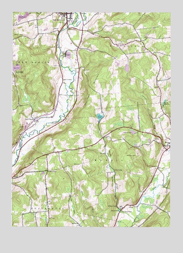
New Berlin South, NY USGS Topographic Map
Click on map above to begin viewing in our Map Viewer.

This topographic map contains these locations and features:
Feature Name Type Latitude Longitude GNIS ID View Map
All Saints ChapelChurchN42.5092°W75.2879°942329View Map
Allen PondLakeN42.5642°W75.3058°942364View Map
Berean Baptist ChurchChurchN42.6242°W75.3308°2490605View Map
Church CornersLocaleN42.5326°W75.3466°946675View Map
Church of the NazareneChurchN42.6247°W75.3322°2490597View Map
Collier BridgeLocaleN42.5320°W75.2932°947144View Map
Dakin Opera House (historical)BuildingN42.6247°W75.3328°2490598View Map
Davis CrossingPopulated PlaceN42.5626°W75.3574°972366View Map
Deming School (historical)SchoolN42.6087°W75.2729°948289View Map
Dimmick Hollow School (historical)SchoolN42.5526°W75.3024°948461View Map
Dimock HollowValleyN42.5067°W75.2818°972144View Map
Fairview CemeteryCemeteryN42.6211°W75.3353°2559164View Map
Filer CornersLocaleN42.5112°W75.2591°950048View Map
First Baptist ChurchChurchN42.6233°W75.3325°2490606View Map
First United Methodist ChurchChurchN42.6203°W75.3314°2490608View Map
Harris HillSummitN42.5420°W75.2802°952263View Map
Hunt PondLakeN42.5926°W75.3722°953466View Map
Hunt's Pond State ParkParkN42.5925°W75.3706°2559642View Map
Johnson FarmsLocaleN42.5953°W75.3247°2556826View Map
Mann CemeteryCemeteryN42.5021°W75.3232°2558749View Map
Morris BrookStreamN42.5029°W75.2777°957687View Map
Morris Central SchoolSchoolN42.5468°W75.2507°2597217View Map
Morris Family Burial GroundCemeteryN42.5090°W75.2877°2558750View Map
Morris PondLakeN42.5096°W75.2899°957696View Map
Morris ReservoirReservoirN42.5728°W75.2548°957697View Map
New BerlinPopulated PlaceN42.6242°W75.3316°958391View Map
New Berlin Central School (historical)SchoolN42.6228°W75.3342°2490602View Map
New Berlin Fire DepartmentBuildingN42.6237°W75.3331°2490601View Map
New Berlin LibraryBuildingN42.6239°W75.3319°2490610View Map
New Berlin Municipal BuildingBuildingN42.6236°W75.3325°2490600View Map
New Eagle Hotel (historical)BuildingN42.6244°W75.3328°2490599View Map
Pickens PondLakeN42.5555°W75.2793°960328View Map
Riverbend Golf CourseLocaleN42.5756°W75.3353°2490611View Map
Sages CrossingPopulated PlaceN42.5854°W75.3349°973033View Map
Saint Andrew's CemeteryCemeteryN42.6218°W75.3332°2490603View Map
Saint Andrew's Episcopal ChurchChurchN42.6219°W75.3325°2490607View Map
Saint Marys FallsFallsN42.5124°W75.2924°963949View Map
School Number 3 (historical)SchoolN42.5901°W75.3363°975251View Map
School Number 4 (historical)SchoolN42.5642°W75.3438°975330View Map
School Number 8 (historical)SchoolN42.5715°W75.3699°975584View Map
Scribner CemeteryCemeteryN42.5938°W75.3374°964705View Map
Shacktown MountainSummitN42.5820°W75.3099°964901View Map
Silver LakeLakeN42.6001°W75.3307°965259View Map
Silver LakePopulated PlaceN42.6015°W75.3324°965263View Map
Town of MorrisCivilN42.5379°W75.2639°979239View Map
Town of PittsfieldCivilN42.6140°W75.2695°979371View Map
Unadilla River BridgeBridgeN42.6162°W75.3314°2615001View Map
Unadilla Valley Central SchoolSchoolN42.5814°W75.3347°2490612View Map
Village of New BerlinCivilN42.6240°W75.3353°2391008View Map
Waltzing Horse FarmLocaleN42.6169°W75.3164°2556825View Map
West HillSummitN42.6117°W75.3732°970766View Map
Wharton CreekStreamN42.6181°W75.3268°970979View Map
Wheeler School (historical)SchoolN42.5348°W75.3343°971016View Map

Note: Coordinates in the location and feature list above are referenced to NAD83 datum.


Copyright (C) 2008-2025 Ryan Niemi / Sunset Dynamics ... All Rights Reserved