TopoQuest Logo
Do you find TopoQuest useful?
Help keep TopoQuest running and adding new maps/features by donating!
Bitcoin:  19c7KJd3qBynnjoSw5npx9KScwjBe4ifkT
Litecoin:  LXs6TkuXGGXo1vDsWCkWVdjQX94eUKd6ui
Home View Maps Find Maps Find Places Resources & Links


Powell, Pennsylvania Topographic Map

USGS Map Title: Powell, PA
USGS Map MRC: 41076F5
DRG (GeoTIFF) Download: o41076f5.tif


Neighboring USGS Topographic Map Quads:


  East Troy, PA  
41076G6
 

  Ulster, PA  
41076G5
 

  Towanda, PA  
41076G4
 

  Leroy, PA  
41076F6
 

  Powell, PA  
41076F5
 

  Monroeton, PA  
41076F4
 

  Shunk, PA  
41076E6
 

  Overton, PA  
41076E5
 

  Dushore, PA  
41076E4


Map MRC Location:

N42°
W77°
N42°
W76°
H8 H7 H6 H5 H4 H3 H2 H1
G8 G7 G6 G5 G4 G3 G2 G1
F8 F7 F6 F5 F4 F3 F2 F1
E8 E7 E6 E5 E4 E3 E2 E1
D8 D7 D6 D5 D4 D3 D2 D1
C8 C7 C6 C5 C4 C3 C2 C1
B8 B7 B6 B5 B4 B3 B2 B1
A8 A7 A6 A5 A4 A3 A2 A1
N41°
W77°
N41°
W76°

Powell, PA USGS 1:24K Topographic Map Preview:
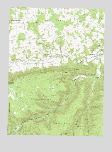
Powell, PA USGS Topographic Map
Click on map above to begin viewing in our Map Viewer.

This topographic map contains these locations and features:
Feature Name Type Latitude Longitude GNIS ID View Map
Barclay StationLocaleN41.6340°W76.6083°1168699View Map
Bull RunStreamN41.6790°W76.5383°1170646View Map
Cash MountainSummitN41.6645°W76.5669°1171304View Map
Cash PondLakeN41.6714°W76.5657°1171305View Map
Chilson RunStreamN41.6315°W76.5405°1192261View Map
Coal RunStreamN41.6326°W76.6069°1172076View Map
Deep HollowValleyN41.6495°W76.5216°1173065View Map
Dodge CemeteryCemeteryN41.7028°W76.5414°2776418View Map
Falls CreekStreamN41.6404°W76.5933°1174602View Map
Franklin CenterLocaleN41.7042°W76.5716°1175145View Map
Franklin Center Christian CemeteryCemeteryN41.7038°W76.5678°2776429View Map
Franklin Township Volunteer Fire and Rescue DepartmentBuildingN41.7035°W76.5532°2652741View Map
FranklindalePopulated PlaceN41.7029°W76.5544°1175178View Map
Franklindale CemeteryCemeteryN41.7052°W76.5512°2776431View Map
French RunStreamN41.7104°W76.5027°1175226View Map
HighlandPopulated PlaceN41.7373°W76.5291°1203803View Map
Lamoka MountainSummitN41.6751°W76.5597°1178833View Map
Long ValleyPopulated PlaceN41.6498°W76.5680°1204055View Map
Long Valley RunStreamN41.6495°W76.5663°1179911View Map
Millstone CreekStreamN41.6831°W76.5111°1192946View Map
Monroe Franklin SchoolSchoolN41.7051°W76.5124°1181435View Map
Naglee MountainSummitN41.6859°W76.5511°1182153View Map
Nates RunStreamN41.6376°W76.6013°1182176View Map
North Branch Towanda CreekStreamN41.6965°W76.6194°1182555View Map
PowellPopulated PlaceN41.7048°W76.5069°1184363View Map
Powell CemeteryCemeteryN41.7090°W76.5097°1184366View Map
Preacher BrookStreamN41.7023°W76.5691°1184387View Map
Schrader CreekStreamN41.7079°W76.5058°1193299View Map
State Game Lands Number 36ParkN41.6548°W76.5844°1188512View Map
Stone MountainSummitN41.6734°W76.5241°1188729View Map
Sugar RunStreamN41.6276°W76.6238°1193495View Map
Township of Barclay (historical)CivilN41.6667°W76.5830°1215975View Map
Township of FranklinCivilN41.6761°W76.5989°1215979View Map
West Franklin CemeteryCemeteryN41.6979°W76.6175°2776519View Map
WestonPopulated PlaceN41.6829°W76.5094°1204935View Map
Willey Family CemeteryCemeteryN41.7026°W76.5559°2776522View Map

Note: Coordinates in the location and feature list above are referenced to NAD83 datum.


Copyright (C) 2008-2025 Ryan Niemi / Sunset Dynamics ... All Rights Reserved