TopoQuest Logo
Do you find TopoQuest useful?
Help keep TopoQuest running and adding new maps/features by donating!
Bitcoin:  19c7KJd3qBynnjoSw5npx9KScwjBe4ifkT
Litecoin:  LXs6TkuXGGXo1vDsWCkWVdjQX94eUKd6ui
Home View Maps Find Maps Find Places Resources & Links


Waynesboro East, Tennessee Topographic Map

USGS Map Title: Waynesboro East, TN
USGS Map MRC: 35087C6
DRG (GeoTIFF) Download: o35087c6.tif


Neighboring USGS Topographic Map Quads:


  Leatherwood, TN  
35087D7
 

  Topsy, TN  
35087D6
 

  Riverside, TN  
35087D5
 

  Waynesboro, TN  
35087C7
 

  Waynesboro East, TN  
35087C6
 

  Ovilla, TN  
35087C5
 

  Three Churches, TN  
35087B7
 

  Collinwood, TN  
35087B6
 

  Westpoint, TN  
35087B5


Map MRC Location:

N36°
W88°
N36°
W87°
H8 H7 H6 H5 H4 H3 H2 H1
G8 G7 G6 G5 G4 G3 G2 G1
F8 F7 F6 F5 F4 F3 F2 F1
E8 E7 E6 E5 E4 E3 E2 E1
D8 D7 D6 D5 D4 D3 D2 D1
C8 C7 C6 C5 C4 C3 C2 C1
B8 B7 B6 B5 B4 B3 B2 B1
A8 A7 A6 A5 A4 A3 A2 A1
N35°
W88°
N35°
W87°

Waynesboro East, TN USGS 1:24K Topographic Map Preview:
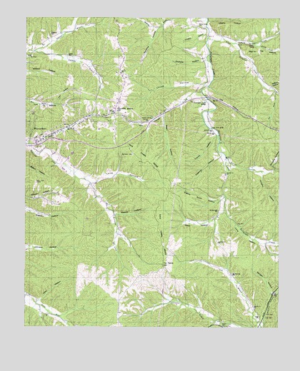
Waynesboro East, TN USGS Topographic Map
Click on map above to begin viewing in our Map Viewer.

This topographic map contains these locations and features:
Feature Name Type Latitude Longitude GNIS ID View Map
Barlow BranchStreamN35.3226°W87.7478°1326578View Map
Barnett BranchStreamN35.3184°W87.6509°1326579View Map
Bedford CemeteryCemeteryN35.2584°W87.7339°1641750View Map
Blowing SpringSpringN35.3640°W87.6375°1326581View Map
Blowing Springs CreekStreamN35.3651°W87.6467°1326561View Map
Blowing Springs School (historical)SchoolN35.3645°W87.6459°1326625View Map
Broach MineMineN35.3370°W87.6853°1641763View Map
Buchanan ProspectsMineN35.3067°W87.6420°1326627View Map
Churchwell ProspectsMineN35.3723°W87.6511°1326628View Map
Cole CemeteryCemeteryN35.2540°W87.6311°1326583View Map
Commissioner District 1CivilN35.3290°W87.7466°2464296View Map
Commissioner District 7CivilN35.3384°W87.6598°2464651View Map
Copeland CemeteryCemeteryN35.3684°W87.7381°1326584View Map
Crews HollowValleyN35.3274°W87.6558°1326585View Map
Crews MineMineN35.3201°W87.6597°1641780View Map
Deering HollowValleyN35.3194°W87.6539°1326586View Map
Dick Cabin RidgeRidgeN35.3101°W87.6825°1326562View Map
Dixon HollowValleyN35.2968°W87.6521°1326587View Map
Dunmire HollowValleyN35.3709°W87.6850°1326588View Map
East Furnace RidgeRidgeN35.3334°W87.6764°1641790View Map
East Furnace Ridge MineMineN35.3354°W87.6772°1641791View Map
Factory CemeteryCemeteryN35.2540°W87.6384°1641794View Map
Fall BranchStreamN35.3462°W87.6278°1326589View Map
Flat HollowValleyN35.3402°W87.7351°1326590View Map
Forge Stack BridgeBridgeN35.3304°W87.6586°1326591View Map
Fortyeight CemeteryCemeteryN35.3417°W87.6622°1641797View Map
Fortyeight Creek BridgeLocaleN35.3420°W87.6614°1326593View Map
Fortyeight Creek Bridge School (historical)SchoolN35.3415°W87.6614°1326629View Map
Fortyeight Creek School (historical)SchoolN35.3123°W87.6514°1326630View Map
Fortyeight Forge (historical)LocaleN35.3306°W87.6578°1641798View Map
Fortyeight Forge CemeteryCemeteryN35.3320°W87.6570°1641799View Map
Fortyeight Freewill Baptist ChurchChurchN35.3417°W87.6617°1641800View Map
Foster HollowValleyN35.3393°W87.6741°1641801View Map
Foster Hollow ProspectMineN35.3381°W87.6720°1326631View Map
Fourmile Board HillSummitN35.3387°W87.7064°1326594View Map
Furnace BranchStreamN35.3459°W87.6634°1326595View Map
Geissler SpringSpringN35.3343°W87.6883°1326596View Map
Granny Scott HollowValleyN35.3014°W87.6539°1326597View Map
Griggs CemeteryCemeteryN35.2542°W87.6342°1326599View Map
Hurricane School (historical)SchoolN35.2992°W87.7097°1326632View Map
Irontop MineMineN35.3704°W87.6786°1641830View Map
John HollowValleyN35.2600°W87.7434°1326601View Map
Keaton Springs MineMineN35.3359°W87.6875°1641832View Map
Keeton CemeteryCemeteryN35.3595°W87.7275°1326603View Map
Lee HollowValleyN35.3426°W87.6604°1326606View Map
Lee HollowValleyN35.3643°W87.6374°1326607View Map
Lee Hollow MinesMineN35.3340°W87.6467°1641839View Map
Lee RidgeRidgeN35.3431°W87.6834°1641840View Map
Lee Ridge MinesMineN35.3445°W87.6764°1641841View Map
Liberty ChurchChurchN35.3348°W87.7114°1326608View Map
Liberty HollowValleyN35.3734°W87.6600°1326609View Map
Limekiln HollowValleyN35.3682°W87.6610°1326610View Map
Little Fortyeight CreekStreamN35.3670°W87.6606°1326611View Map
Long CemeteryCemeteryN35.2920°W87.6459°1326612View Map
Long HollowValleyN35.3081°W87.7176°1326613View Map
Long HollowValleyN35.2962°W87.6516°1326614View Map
Long Hollow BranchStreamN35.3079°W87.7181°1646843View Map
Louse HollowValleyN35.3490°W87.6610°1326615View Map
Louse Hollow BranchStreamN35.3492°W87.6586°1646844View Map
McGee CemeteryCemeteryN35.2520°W87.6528°1326616View Map
Morgan HollowValleyN35.2628°W87.6279°1326618View Map
Mount HopePopulated PlaceN35.3592°W87.7478°1326619View Map
Mount Hope CemeteryCemeteryN35.3592°W87.7492°1641855View Map
Mount Hope CemeteryCemeteryN35.3590°W87.7486°1641857View Map
Mount Hope Christian ChurchChurchN35.3590°W87.7478°1641858View Map
Mount Hope Methodist ChurchChurchN35.3590°W87.7489°1641859View Map
Mount Hope School (historical)SchoolN35.3592°W87.7472°1326633View Map
Murphy HollowValleyN35.3142°W87.6273°1326620View Map
Murphy MineMineN35.3223°W87.6578°1641861View Map
Negro HollowValleyN35.3363°W87.6820°1326621View Map
Negro RidgeRidgeN35.3265°W87.6867°1641862View Map
Negro Ridge MineMineN35.3329°W87.6834°1641863View Map
Nutt ProspectMineN35.3726°W87.6747°1326634View Map
Oldtown BranchStreamN35.3612°W87.7456°1326622View Map
Orchard HollowValleyN35.3574°W87.6621°1326623View Map
Perigo MineMineN35.3426°W87.6884°1641879View Map
Raburn HollowValleyN35.3472°W87.6290°1326624View Map
Robinette ProspectMineN35.3537°W87.6486°1326635View Map
Sapling MineMineN35.3265°W87.6614°1641900View Map
Shell ChurchChurchN35.3315°W87.7286°1326566View Map
South Fork Blowing Springs CreekStreamN35.3645°W87.6381°1326568View Map
Staggs CemeteryCemeteryN35.3615°W87.6364°1326569View Map
Stoeball BranchStreamN35.2529°W87.6561°1326570View Map
Sweetwater BranchStreamN35.2501°W87.6431°1326571View Map
Tie Camp HillSummitN35.2756°W87.6822°1326572View Map
Timothy HollowValleyN35.3127°W87.6332°1326573View Map
Valleyview SubdivisionPopulated PlaceN35.3173°W87.7320°1326636View Map
Walnut Grove CemeteryCemeteryN35.3723°W87.6659°1326574View Map
Wayne County Memorial GardensCemeteryN35.3384°W87.7064°1641920View Map
Wayne Furnace (historical)LocaleN35.3373°W87.6781°1641923View Map
Waynesboro Division (historical)CensusN35.3115°W87.7275°1649008View Map
Weaver HollowValleyN35.2951°W87.7059°1326576View Map
West Fork Fortyeight CreekStreamN35.2967°W87.6520°1326637View Map
West Furnace RidgeRidgeN35.3334°W87.6792°1641924View Map
West Furnace Ridge MineMineN35.3348°W87.6809°1641925View Map
West MineMineN35.3270°W87.6695°1641926View Map
WNBG-AM (Waynesboro)TowerN35.3084°W87.7456°1639850View Map

Note: Coordinates in the location and feature list above are referenced to NAD83 datum.


Copyright (C) 2008-2024 Ryan Niemi / Sunset Dynamics ... All Rights Reserved