TopoQuest Logo
Do you find TopoQuest useful?
Help keep TopoQuest running and adding new maps/features by donating!
Bitcoin:  19c7KJd3qBynnjoSw5npx9KScwjBe4ifkT
Litecoin:  LXs6TkuXGGXo1vDsWCkWVdjQX94eUKd6ui
Home View Maps Find Maps Find Places Resources & Links


Guilford, New York Topographic Map

USGS Map Title: Guilford, NY
USGS Map MRC: 42075D4
DRG (GeoTIFF) Download: o42075d4.tif


Neighboring USGS Topographic Map Quads:


  Norwich, NY  
42075E5
 

  Holmesville, NY  
42075E4
 

  New Berlin South, NY  
42075E3
 

  Oxford, NY  
42075D5
 

  Guilford, NY  
42075D4
 

  Gilbertsville, NY  
42075D3
 

  West Bainbridge, NY  
42075C5
 

  Sidney, NY  
42075C4
 

  Unadilla, NY  
42075C3


Map MRC Location:

N43°
W76°
N43°
W75°
H8 H7 H6 H5 H4 H3 H2 H1
G8 G7 G6 G5 G4 G3 G2 G1
F8 F7 F6 F5 F4 F3 F2 F1
E8 E7 E6 E5 E4 E3 E2 E1
D8 D7 D6 D5 D4 D3 D2 D1
C8 C7 C6 C5 C4 C3 C2 C1
B8 B7 B6 B5 B4 B3 B2 B1
A8 A7 A6 A5 A4 A3 A2 A1
N42°
W76°
N42°
W75°

Guilford, NY USGS 1:24K Topographic Map Preview:
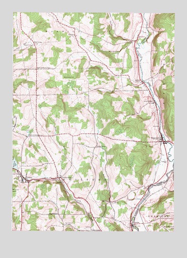
Guilford, NY USGS Topographic Map
Click on map above to begin viewing in our Map Viewer.

This topographic map contains these locations and features:
Feature Name Type Latitude Longitude GNIS ID View Map
Borden Hose Company 1 Mount Upton StationBuildingN42.4250°W75.3807°2734712View Map
Borden Hose Company 1 Rockdale StationBuildingN42.3776°W75.4079°2734711View Map
Evergreen CemeteryCemeteryN42.4836°W75.4065°949753View Map
Foote CemeteryCemeteryN42.3773°W75.4391°950367View Map
Godfrey CornersLocaleN42.4231°W75.4360°951273View Map
Godfrey Corners CemeteryCemeteryN42.4233°W75.4412°2559175View Map
GuilfordPopulated PlaceN42.4042°W75.4896°951905View Map
Guilford Census Designated PlaceCensusN42.4072°W75.4898°2628163View Map
Guilford CenterPopulated PlaceN42.4054°W75.4621°951906View Map
Guilford Center CemeteryCemeteryN42.4081°W75.4654°2559174View Map
Guilford Elementary SchoolSchoolN42.4073°W75.4888°2668854View Map
Guilford LakeLakeN42.4129°W75.4993°951908View Map
Guilford Post OfficePost OfficeN42.4055°W75.4913°2617949View Map
Guilford United Methodist ChurchChurchN42.4050°W75.4899°2616442View Map
Guilford Volunteer Fire DepartmentBuildingN42.4046°W75.4918°2734743View Map
High BridgeLocaleN42.3920°W75.4241°952721View Map
Ives SettlementPopulated PlaceN42.3845°W75.4635°972660View Map
Ives Settlement CemeteryCemeteryN42.3787°W75.4588°953864View Map
Kent BrookStreamN42.3876°W75.4032°954532View Map
Lathams CornersPopulated PlaceN42.4601°W75.3988°955069View Map
Maplewood CemeteryCemeteryN42.4152°W75.3802°956469View Map
Moses BrookStreamN42.4070°W75.4635°957726View Map
Mount UptonPopulated PlaceN42.4265°W75.3832°957915View Map
North Guilford CornersLocaleN42.4676°W75.4816°958799View Map
ParkerPopulated PlaceN42.4029°W75.4618°972916View Map
RockdalePopulated PlaceN42.3781°W75.4077°962747View Map
Rockwells MillsPopulated PlaceN42.4487°W75.3899°962770View Map
School Number 10 (historical)SchoolN42.4809°W75.4855°974935View Map
School Number 2 (historical)SchoolN42.4867°W75.4033°2105813View Map
School Number 2 (historical)SchoolN42.3789°W75.4039°2106393View Map
School Number 9 (historical)SchoolN42.4294°W75.4800°2105814View Map
School Number 9 (historical)SchoolN42.4870°W75.4527°975623View Map
Shumway HillSummitN42.4642°W75.4577°965193View Map
Town of GuilfordCivilN42.4014°W75.4572°979031View Map
Trestle CornersLocaleN42.3754°W75.4310°967795View Map
Webb CornersLocaleN42.4820°W75.4835°968971View Map
White StorePopulated PlaceN42.4859°W75.4035°971137View Map
White Store BrookStreamN42.4884°W75.3955°971138View Map
White Store FallsFallsN42.4779°W75.4175°971139View Map
Windsor CornersLocaleN42.4292°W75.4796°971476View Map

Note: Coordinates in the location and feature list above are referenced to NAD83 datum.


Copyright (C) 2008-2025 Ryan Niemi / Sunset Dynamics ... All Rights Reserved