TopoQuest Logo
Do you find TopoQuest useful?
Help keep TopoQuest running and adding new maps/features by donating!
Bitcoin:  19c7KJd3qBynnjoSw5npx9KScwjBe4ifkT
Litecoin:  LXs6TkuXGGXo1vDsWCkWVdjQX94eUKd6ui
Home View Maps Find Maps Find Places Resources & Links


Packsaddle Butte, Montana Topographic Map

USGS Map Title: Packsaddle Butte, MT
USGS Map MRC: 45109F7
DRG (GeoTIFF) Download: o45109f7.tif


Neighboring USGS Topographic Map Quads:


  Big Timber, MT  
45109G8
 

  Greycliff, MT  
45109G7
 

  Lone Indian Butte, MT  
45109G6
 

  Ross Canyon, MT  
45109F8
 

  Packsaddle Butte, MT  
45109F7
 

  Work Creek, MT  
45109F6
 

  Sliderock Mountain, MT  
45109E8
 

  Wildcat Draw, MT  
45109E7
 

  Cow Face Hill, MT  
45109E6


Map MRC Location:

N46°
W110°
N46°
W109°
H8 H7 H6 H5 H4 H3 H2 H1
G8 G7 G6 G5 G4 G3 G2 G1
F8 F7 F6 F5 F4 F3 F2 F1
E8 E7 E6 E5 E4 E3 E2 E1
D8 D7 D6 D5 D4 D3 D2 D1
C8 C7 C6 C5 C4 C3 C2 C1
B8 B7 B6 B5 B4 B3 B2 B1
A8 A7 A6 A5 A4 A3 A2 A1
N45°
W110°
N45°
W109°

Packsaddle Butte, MT USGS 1:24K Topographic Map Preview:
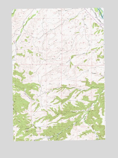
Packsaddle Butte, MT USGS Topographic Map
Click on map above to begin viewing in our Map Viewer.

This topographic map contains these locations and features:
Feature Name Type Latitude Longitude GNIS ID View Map
01S15E22ABCC01 WellWellN45.7377°W109.8585°811553View Map
01S15E22ACCC01 SpringSpringN45.7335°W109.8585°811514View Map
01S16E17DCBA01 WellWellN45.7424°W109.7763°811590View Map
02S15E03ABBA01 SpringSpringN45.6969°W109.8594°811213View Map
02S16E20ACCA01 SpringSpringN45.6463°W109.7757°810782View Map
Bear Chip CouleeValleyN45.6516°W109.7735°779475View Map
Black Butte TrailTrailN45.6308°W109.8649°779981View Map
Captain William Clark Historical MarkerParkN45.7355°W109.7571°1743460View Map
Crazy Mountains Historical MarkerParkN45.7355°W109.7571°1743459View Map
Derby GulchValleyN45.6302°W109.8155°782306View Map
East Bridger CreekStreamN45.6252°W109.7613°782786View Map
Fahlgren GulchValleyN45.7499°W109.7535°771284View Map
Greycliff Rest AreaLocaleN45.7355°W109.7571°1743458View Map
Packsaddle ButteSummitN45.6352°W109.8566°788562View Map
Thomas Party Historical MarkerParkN45.7355°W109.7571°1743461View Map
West Bridger CreekStreamN45.6483°W109.7788°792957View Map
West Bridger StationLocaleN45.6272°W109.8280°792958View Map

Note: Coordinates in the location and feature list above are referenced to NAD83 datum.


Copyright (C) 2008-2025 Ryan Niemi / Sunset Dynamics ... All Rights Reserved