TopoQuest Logo
Do you find TopoQuest useful?
Help keep TopoQuest running and adding new maps/features by donating!
Bitcoin:  19c7KJd3qBynnjoSw5npx9KScwjBe4ifkT
Litecoin:  LXs6TkuXGGXo1vDsWCkWVdjQX94eUKd6ui
Home View Maps Find Maps Find Places Resources & Links


Wildcat Draw, Montana Topographic Map

USGS Map Title: Wildcat Draw, MT
USGS Map MRC: 45109E7
DRG (GeoTIFF) Download: o45109e7.tif


Neighboring USGS Topographic Map Quads:


  Ross Canyon, MT  
45109F8
 

  Packsaddle Butte, MT  
45109F7
 

  Work Creek, MT  
45109F6
 

  Sliderock Mountain, MT  
45109E8
 

  Wildcat Draw, MT  
45109E7
 

  Cow Face Hill, MT  
45109E6
 

  Meyer Mountain, MT  
45109D8
 

  Nye, MT  
45109D7
 

  Beehive, MT  
45109D6


Map MRC Location:

N46°
W110°
N46°
W109°
H8 H7 H6 H5 H4 H3 H2 H1
G8 G7 G6 G5 G4 G3 G2 G1
F8 F7 F6 F5 F4 F3 F2 F1
E8 E7 E6 E5 E4 E3 E2 E1
D8 D7 D6 D5 D4 D3 D2 D1
C8 C7 C6 C5 C4 C3 C2 C1
B8 B7 B6 B5 B4 B3 B2 B1
A8 A7 A6 A5 A4 A3 A2 A1
N45°
W110°
N45°
W109°

Wildcat Draw, MT USGS 1:24K Topographic Map Preview:
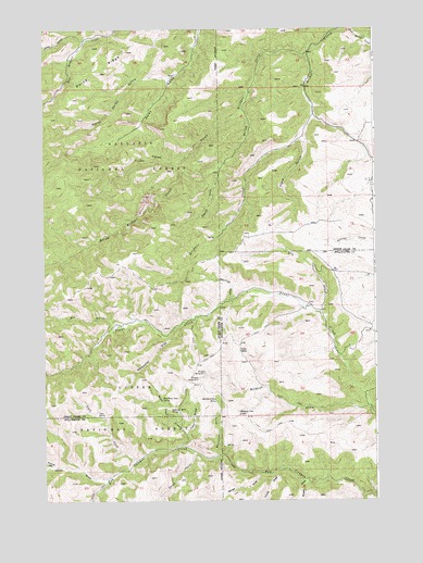
Wildcat Draw, MT USGS Topographic Map
Click on map above to begin viewing in our Map Viewer.

This topographic map contains these locations and features:
Feature Name Type Latitude Longitude GNIS ID View Map
03S16E09DACC01 WellWellN45.5847°W109.7521°810268View Map
Beartrap DrawValleyN45.5536°W109.8049°779579View Map
Blind Bridger CreekStreamN45.6188°W109.7746°780104View Map
Boundary DrawValleyN45.5122°W109.8099°780289View Map
Boundary Draw SpringSpringN45.5267°W109.8110°780290View Map
Carey GulchValleyN45.6027°W109.8010°780938View Map
Clark GulchValleyN45.5952°W109.7771°781320View Map
Derby RidgeRidgeN45.6066°W109.8635°782308View Map
Dry DrawValleyN45.5499°W109.7716°782593View Map
Dry GulchValleyN45.5469°W109.8485°782613View Map
Hookum Cow CabinLocaleN45.5227°W109.8024°784990View Map
Jims GulchValleyN45.6219°W109.8596°785494View Map
Long DrawValleyN45.5011°W109.7557°806119View Map
Lundy DrawValleyN45.5083°W109.7860°793862View Map
McKinsey DrawValleyN45.5094°W109.8707°787085View Map
McKinsey SpringSpringN45.5199°W109.8721°794839View Map
Mendenhall DrawValleyN45.5461°W109.8243°787185View Map
North Derby GulchValleyN45.6119°W109.8280°788084View Map
Oliver DrawValleyN45.5061°W109.8521°788441View Map
Porcupine SpringSpringN45.5019°W109.8610°794838View Map
Russel DrawValleyN45.5049°W109.7757°799377View Map
Sawmill GulchValleyN45.5869°W109.8091°790065View Map
September Morn SpringSpringN45.5239°W109.8253°790234View Map
Smith CouleeValleyN45.5122°W109.8191°790709View Map
Tepee CreekStreamN45.5105°W109.8413°791976View Map
Tepee SpringSpringN45.5226°W109.8550°791998View Map
Trail DrawValleyN45.5177°W109.8221°792320View Map
West Trail DrawValleyN45.5149°W109.8238°793133View Map
West Trail Draw SpringSpringN45.5270°W109.8309°793134View Map
White DrawValleyN45.5030°W109.8274°793194View Map
White SpringSpringN45.5011°W109.8118°794837View Map
Wildcat DrawValleyN45.5247°W109.7535°793297View Map
Wildcat Spring Number OneSpringN45.5340°W109.8149°793302View Map
Wildcat Spring Number TwoSpringN45.5325°W109.8175°793303View Map
Winge DrawValleyN45.5080°W109.7932°793417View Map
Yates CabinLocaleN45.5399°W109.8018°793598View Map

Note: Coordinates in the location and feature list above are referenced to NAD83 datum.


Copyright (C) 2008-2025 Ryan Niemi / Sunset Dynamics ... All Rights Reserved