TopoQuest Logo
Do you find TopoQuest useful?
Help keep TopoQuest running and adding new maps/features by donating!
Bitcoin:  19c7KJd3qBynnjoSw5npx9KScwjBe4ifkT
Litecoin:  LXs6TkuXGGXo1vDsWCkWVdjQX94eUKd6ui
Home View Maps Find Maps Find Places Resources & Links


Page Ranch, Utah Topographic Map

USGS Map Title: Page Ranch, UT
USGS Map MRC: 37113E4
DRG (GeoTIFF) Download: o37113e4.tif


Neighboring USGS Topographic Map Quads:


  Newcastle, UT  
37113F5
 

  Silver Peak, UT  
37113F4
 

  Desert Mound, UT  
37113F3
 

  Pinto, UT  
37113E5
 

  Page Ranch, UT  
37113E4
 

  Stoddard Mountain, UT  
37113E3
 

  Central East, UT  
37113D5
 

  Grass Valley, UT  
37113D4
 

  New Harmony, UT  
37113D3


Map MRC Location:

N38°
W114°
N38°
W113°
H8 H7 H6 H5 H4 H3 H2 H1
G8 G7 G6 G5 G4 G3 G2 G1
F8 F7 F6 F5 F4 F3 F2 F1
E8 E7 E6 E5 E4 E3 E2 E1
D8 D7 D6 D5 D4 D3 D2 D1
C8 C7 C6 C5 C4 C3 C2 C1
B8 B7 B6 B5 B4 B3 B2 B1
A8 A7 A6 A5 A4 A3 A2 A1
N37°
W114°
N37°
W113°

Page Ranch, UT USGS 1:24K Topographic Map Preview:
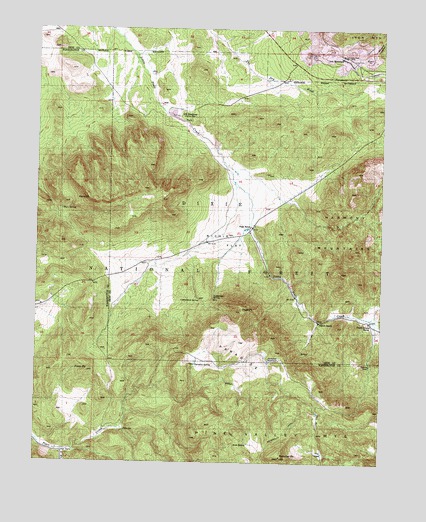
Page Ranch, UT USGS Topographic Map
Click on map above to begin viewing in our Map Viewer.

This topographic map contains these locations and features:
Feature Name Type Latitude Longitude GNIS ID View Map
Big Hollow SpringSpringN37.5822°W113.3752°1438691View Map
Big Hollow TrailTrailN37.5711°W113.3858°1450048View Map
Blowout HollowValleyN37.6180°W113.3800°1438923View Map
Blowout PitBasinN37.6166°W113.3813°1448152View Map
Colorado Mine (historical)MineN37.6155°W113.3791°1448296View Map
Columbia Steel MineMineN37.6169°W113.3894°1439900View Map
Cottonwood SpringSpringN37.5470°W113.4416°1440038View Map
Gordon SpringSpringN37.5281°W113.3799°1451253View Map
Grants RanchLocaleN37.5405°W113.3980°1441419View Map
Iron MountainPopulated PlaceN37.6175°W113.3908°1442049View Map
Kane PointCapeN37.5761°W113.4819°1442272View Map
Kane SpringSpringN37.5729°W113.4917°1442274View Map
Lamb ReservoirReservoirN37.6055°W113.4587°1447631View Map
Lockeridge SpringSpringN37.5472°W113.4365°1442829View Map
Long FlatFlatN37.5128°W113.3980°1442903View Map
Old IrontownPopulated PlaceN37.6000°W113.4502°1444069View Map
Page PointSummitN37.5436°W113.4263°1444156View Map
Page RanchLocaleN37.5680°W113.4230°1444157View Map
ParadiseSummitN37.5316°W113.4258°1444177View Map
Paradise ReservoirReservoirN37.5295°W113.4164°1444193View Map
Paradise SpringSpringN37.5285°W113.4431°1444194View Map
Pinto PeakSummitN37.5264°W113.4822°1444432View Map
Pinto SpringSpringN37.5088°W113.4678°1444433View Map
Rencher PeakSummitN37.5016°W113.4113°1444864View Map
Richie FlatFlatN37.5664°W113.4311°1444891View Map
Rock SpringSpringN37.5055°W113.4239°1445086View Map
South Fork Pinto CreekStreamN37.5033°W113.4908°1432702View Map
Stewart Lamb DamDamN37.6033°W113.4575°1447632View Map
The CoveValleyN37.5028°W113.3961°1446433View Map
The DairyFlatN37.5028°W113.4908°1446436View Map
Upper Grants RanchLocaleN37.5408°W113.3797°1446861View Map
Upper Grants Ranch TrailTrailN37.5197°W113.3816°1449986View Map
Whiterocks TrailTrailN37.5103°W113.4083°1434213View Map

Note: Coordinates in the location and feature list above are referenced to NAD83 datum.


Copyright (C) 2008-2025 Ryan Niemi / Sunset Dynamics ... All Rights Reserved