TopoQuest Logo
Do you find TopoQuest useful?
Help keep TopoQuest running and adding new maps/features by donating!
Bitcoin:  19c7KJd3qBynnjoSw5npx9KScwjBe4ifkT
Litecoin:  LXs6TkuXGGXo1vDsWCkWVdjQX94eUKd6ui
Home View Maps Find Maps Find Places Resources & Links


Gridley, California Topographic Map

USGS Map Title: Gridley, CA
USGS Map MRC: 39121C6
DRG (GeoTIFF) Download: o39121c6.tif


Neighboring USGS Topographic Map Quads:


  West of Biggs, CA  
39121D7
 

  Biggs, CA  
39121D6
 

  Palermo, CA  
39121D5
 

  Pennington, CA  
39121C7
 

  Gridley, CA  
39121C6
 

  Honcut, CA  
39121C5
 

  Sutter Buttes, CA  
39121B7
 

  Sutter, CA  
39121B6
 

  Yuba City, CA  
39121B5


Map MRC Location:

N40°
W122°
N40°
W121°
H8 H7 H6 H5 H4 H3 H2 H1
G8 G7 G6 G5 G4 G3 G2 G1
F8 F7 F6 F5 F4 F3 F2 F1
E8 E7 E6 E5 E4 E3 E2 E1
D8 D7 D6 D5 D4 D3 D2 D1
C8 C7 C6 C5 C4 C3 C2 C1
B8 B7 B6 B5 B4 B3 B2 B1
A8 A7 A6 A5 A4 A3 A2 A1
N39°
W122°
N39°
W121°

Gridley, CA USGS 1:24K Topographic Map Preview:
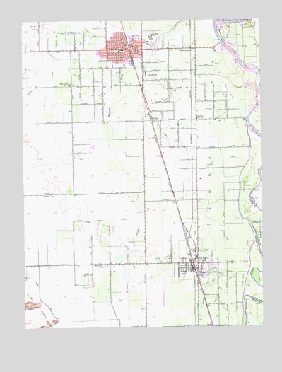
Gridley, CA USGS Topographic Map
Click on map above to begin viewing in our Map Viewer.

This topographic map contains these locations and features:
Feature Name Type Latitude Longitude GNIS ID View Map
Barber Branch Sutter County Free LibraryBuildingN39.2807°W121.6611°1703355View Map
Biggs Gridley Memorial HospitalHospitalN39.3674°W121.6895°1658058View Map
Bihlman (historical)Populated PlaceN39.2643°W121.6619°1703356View Map
BogaCivilN39.3082°W121.6511°233528View Map
Bowles AirportAirportN39.2860°W121.6941°1653609View Map
Butte County FairgroundsLocaleN39.3652°W121.6827°1723925View Map
Butte County Fire Department Station 74BuildingN39.3635°W121.6858°2621862View Map
Calvary Baptist ChurchChurchN39.3632°W121.7053°1723927View Map
Calvary Chapel of GridleyChurchN39.3599°W121.6989°1723928View Map
Chandon (historical)Populated PlaceN39.3143°W121.6622°1666773View Map
Church of the NazareneChurchN39.2741°W121.6639°1703363View Map
Church of the NazareneChurchN39.3604°W121.7003°1723934View Map
City of GridleyCivilN39.3622°W121.6971°2410665View Map
City of Live OakCivilN39.2788°W121.6624°2410846View Map
Cox SpillwayCanalN39.3346°W121.6344°233731View Map
East GridleyPopulated PlaceN39.3632°W121.6619°222907View Map
FaganPopulated PlaceN39.3360°W121.6836°1658518View Map
First Baptist ChurchChurchN39.3582°W121.6969°1723947View Map
First Church of Christ ScientistChurchN39.3638°W121.6980°1723950View Map
First Presbyterian ChurchChurchN39.3632°W121.6966°1723953View Map
Grace Lutheran ChurchChurchN39.3629°W121.6930°1723957View Map
GridleyPopulated PlaceN39.3638°W121.6936°277526View Map
Gridley Branch Butte County LibraryBuildingN39.3666°W121.6911°1723958View Map
Gridley Christian ChurchChurchN39.3649°W121.6939°1723959View Map
Gridley City HallBuildingN39.3654°W121.6972°1723960View Map
Gridley City Volunteer Fire Department Station 76BuildingN39.3651°W121.6973°2622274View Map
Gridley Colony Number One (historical)Populated PlaceN39.3343°W121.6622°1666781View Map
Gridley Colony Number Two (historical)Populated PlaceN39.3507°W121.6622°1666782View Map
Gridley High SchoolSchoolN39.3679°W121.6841°236821View Map
Gridley Police DepartmentBuildingN39.3654°W121.6975°2751018View Map
Gridley Post OfficePost OfficeN39.3636°W121.6955°1723961View Map
Hedger SchoolSchoolN39.2749°W121.7133°225114View Map
Heritage Oak Shopping CenterLocaleN39.3613°W121.6872°1723963View Map
Iglesia Gentil De CristoChurchN39.3588°W121.6978°1723968View Map
Kingdom Hall of Jehovahs WitnessesChurchN39.3591°W121.7058°1723971View Map
Leo Chesney Correctional CenterLocaleN39.2679°W121.6650°1703390View Map
Lighthouse TabernacleChurchN39.3674°W121.6986°1723974View Map
Live OakPopulated PlaceN39.2757°W121.6600°277541View Map
Live Oak Alternative SchoolSchoolN39.2763°W121.6549°1703395View Map
Live Oak CanalCanalN39.2702°W121.6527°227416View Map
Live Oak CemeteryCemeteryN39.2768°W121.6788°227420View Map
Live Oak DivisionCivilN39.2524°W121.6863°1935170View Map
Live Oak Fire DepartmentBuildingN39.2742°W121.6646°2621789View Map
Live Oak High SchoolSchoolN39.2767°W121.6574°236819View Map
Live Oak Memorial ParkParkN39.2771°W121.6658°1703392View Map
Live Oak Middle SchoolSchoolN39.2754°W121.6530°1703393View Map
Live Oak Post OfficePost OfficeN39.2748°W121.6630°1703394View Map
Luther Elementary SchoolSchoolN39.2782°W121.6679°227852View Map
Main Chandon LateralCanalN39.2935°W121.7064°227965View Map
Manuel Vierra ParkParkN39.3593°W121.6911°1723975View Map
Manzanita Elementary SchoolSchoolN39.3349°W121.6591°228051View Map
Manzanita Fire StationBuildingN39.3343°W121.6830°228036View Map
McKinley Elementary SchoolSchoolN39.3629°W121.6969°228410View Map
Nick Daddow PlazaParkN39.3646°W121.6953°1723978View Map
Riviera (historical)Populated PlaceN39.3016°W121.6625°1703419View Map
Sacred Heart Catholic ChurchChurchN39.3641°W121.7036°1723997View Map
Saint Timothys Episcopal ChurchChurchN39.3635°W121.6925°1724001View Map
Seventh Day Adventist ChurchChurchN39.3616°W121.7003°1724004View Map
SunsetPopulated PlaceN39.2504°W121.6519°1659925View Map
Sunset Avenue LateralCanalN39.2638°W121.6464°235802View Map
Sutter Butte CanalCanalN39.3152°W121.6350°235843View Map
Sutter County Sheriff's Office - Live Oak SubstationBuildingN39.2742°W121.6648°2751074View Map
Sycamore Elementary SchoolSchoolN39.3624°W121.6994°1724009View Map
Traynor LateralCanalN39.3502°W121.7344°236527View Map
Truth TabernacleChurchN39.3610°W121.6897°1724014View Map
Valley Oak Continuation High SchoolSchoolN39.2763°W121.6550°1703453View Map
West Liberty SchoolSchoolN39.3491°W121.7253°237496View Map
Wilson Elementary SchoolSchoolN39.3627°W121.6905°238151View Map

Note: Coordinates in the location and feature list above are referenced to NAD83 datum.


Copyright (C) 2008-2024 Ryan Niemi / Sunset Dynamics ... All Rights Reserved