TopoQuest Logo
Do you find TopoQuest useful?
Help keep TopoQuest running and adding new maps/features by donating!
Bitcoin:  19c7KJd3qBynnjoSw5npx9KScwjBe4ifkT
Litecoin:  LXs6TkuXGGXo1vDsWCkWVdjQX94eUKd6ui
Home View Maps Find Maps Find Places Resources & Links


Vandalia, Illinois Topographic Map

USGS Map Title: Vandalia, IL
USGS Map MRC: 38089H1
DRG (GeoTIFF) Download: o38089h1.tif


Neighboring USGS Topographic Map Quads:


  Bingham, IL  
39089A2
 

  Vera, IL  
39089A1
 

  Avena, IL  
39088A8
 

  Hagarstown, IL  
38089H2
 

  Vandalia, IL  
38089H1
 

  Brownstown, IL  
38088H8
 

  Wildcat Lake, IL  
38089G2
 

  Patoka, IL  
38089G1
 

  Saint Paul, IL  
38088G8


Map MRC Location:

N39°
W90°
N39°
W89°
H8 H7 H6 H5 H4 H3 H2 H1
G8 G7 G6 G5 G4 G3 G2 G1
F8 F7 F6 F5 F4 F3 F2 F1
E8 E7 E6 E5 E4 E3 E2 E1
D8 D7 D6 D5 D4 D3 D2 D1
C8 C7 C6 C5 C4 C3 C2 C1
B8 B7 B6 B5 B4 B3 B2 B1
A8 A7 A6 A5 A4 A3 A2 A1
N38°
W90°
N38°
W89°

Vandalia, IL USGS 1:24K Topographic Map Preview:
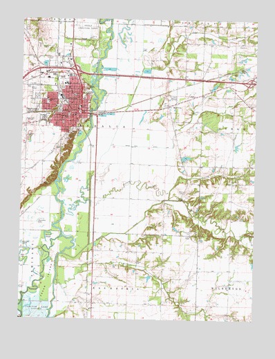
Vandalia, IL USGS Topographic Map
Click on map above to begin viewing in our Map Viewer.

This topographic map contains these locations and features:
Feature Name Type Latitude Longitude GNIS ID View Map
Bear CreekStreamN38.9820°W89.0856°403293View Map
Bluff CityPopulated PlaceN38.9639°W89.0465°422479View Map
Britton CemeteryCemeteryN38.8989°W89.0626°404881View Map
Camp CreekStreamN38.9795°W89.0601°405445View Map
Central SchoolSchoolN38.9634°W89.0934°405882View Map
City of VandaliaCivilN38.9753°W89.1117°2397119View Map
Edwards School (historical)SchoolN38.9067°W89.0490°1736941View Map
Evans Public LibraryBuildingN38.9600°W89.0962°1773061View Map
Fairlawn CemeteryCemeteryN38.9514°W89.1006°408178View Map
Fayette County CourthouseBuildingN38.9600°W89.0998°1736947View Map
Fayette County HospitalHospitalN38.9697°W89.0986°1773065View Map
Fayette County JailBuildingN38.9592°W89.0937°1773067View Map
Fayette County MuseumBuildingN38.9620°W89.0934°1773066View Map
Fayette County Sheriff's OfficeBuildingN38.9601°W89.0996°2758971View Map
First Baptist ChurchChurchN38.9600°W89.0978°1773068View Map
First Christian ChurchChurchN38.9642°W89.0965°1773069View Map
First Methodist ChurchChurchN38.9628°W89.0951°1773070View Map
First Presbyterian ChurchChurchN38.9620°W89.0934°1773073View Map
Free Methodist ChurchChurchN38.9625°W89.0942°1773072View Map
Greer ParkParkN38.9728°W89.1040°1773075View Map
Haley ChapelChurchN38.9678°W89.0328°409631View Map
Haley Chapel CemeteryCemeteryN38.9700°W89.0328°1802264View Map
Hickory CreekStreamN38.9023°W89.1028°410146View Map
Hickory Ridge School (historical)SchoolN38.9375°W89.1234°1736953View Map
Hook LakeLakeN38.9030°W89.1237°410490View Map
Horseshoe LakeLakeN38.9164°W89.1145°410571View Map
Inman SloughLakeN38.9105°W89.1099°410905View Map
Interchange 63CrossingN38.9787°W89.0962°1773079View Map
Interchange 68CrossingN38.9742°W89.0031°1773080View Map
James Hall LibraryBuildingN38.9656°W89.0984°1773082View Map
Jefferson Elementary SchoolSchoolN38.9659°W89.1112°411062View Map
Kelley ParkParkN38.9625°W89.1151°1773084View Map
Lincoln Elementary SchoolSchoolN38.9684°W89.0973°412152View Map
Little Brick HouseBuildingN38.9656°W89.0984°1773088View Map
Little Hickory CreekStreamN38.9106°W89.0056°412352View Map
Luster ChapelChurchN38.9098°W89.0337°412747View Map
Mitchell Family CemeteryCemeteryN38.9778°W89.0189°1802268View Map
Morton CemeteryCemeteryN38.9320°W89.0128°413863View Map
Mother of Dolors CemeteryCemeteryN38.9534°W89.0987°413891View Map
Mother of Dolors Roman Catholic ChurchChurchN38.9650°W89.0984°1773092View Map
Old Hickory CreekStreamN38.9245°W89.0876°415021View Map
Old State Burial GroundCemeteryN38.9575°W89.0926°415065View Map
Overcup ChurchChurchN38.9331°W89.0123°415265View Map
Overcup CreekStreamN38.9248°W89.0459°415266View Map
Overcup School (historical)SchoolN38.9317°W89.0120°1736975View Map
Pecan IslandIslandN38.8900°W89.1101°415499View Map
Pentecostal ChurchChurchN38.9609°W89.1037°1773095View Map
Pinhook (historical)Populated PlaceN38.9103°W89.0342°1773097View Map
Pinhook CemeteryCemeteryN38.9117°W89.0334°415714View Map
Richland CreekStreamN38.8912°W89.1053°416605View Map
Ritter CemeteryCemeteryN38.9839°W89.1115°416698View Map
Ritter School (historical)SchoolN38.9848°W89.1198°1736986View Map
Robbins Best Western Motel HeliportAirportN38.9667°W89.1001°427888View Map
Rogier ParkParkN38.9714°W89.1034°1773104View Map
Saint James Evangelical Lutheran ChurchChurchN38.9609°W89.0998°1773107View Map
Sandy RunStreamN38.9525°W89.0426°417999View Map
Sandy Run DitchCanalN38.9470°W89.0606°418000View Map
Schwarms School (historical)SchoolN38.9742°W89.0120°1736993View Map
Shobonier Elementary SchoolSchoolN38.8795°W89.0878°418448View Map
Simms ParkParkN38.9570°W89.1028°1773115View Map
South Hill CemeteryCemeteryN38.9534°W89.0962°418787View Map
Stanbery LakeReservoirN38.9424°W89.0372°1691771View Map
Stanbery Lake DamDamN38.9417°W89.0384°1691770View Map
State HouseBuildingN38.9612°W89.0940°1737002View Map
Thompson School (historical)SchoolN38.9389°W89.0381°1737004View Map
Township of VandaliaCivilN38.9547°W89.0836°429862View Map
VandaliaPopulated PlaceN38.9606°W89.0937°420228View Map
Vandalia City CemeteryCemeteryN38.9545°W89.0956°1965922View Map
Vandalia City HallBuildingN38.9600°W89.0965°1773119View Map
Vandalia Community High SchoolSchoolN38.9731°W89.1009°1737008View Map
Vandalia Country ClubLocaleN38.9500°W89.1003°1773120View Map
Vandalia DitchCanalN38.9409°W89.0831°420229View Map
Vandalia Middle SchoolSchoolN38.9756°W89.1028°1773121View Map
Vandalia Police DepartmentBuildingN38.9601°W89.0964°2758847View Map
Vandalia Post OfficePost OfficeN38.9594°W89.0944°1737009View Map
Vandalia Sand and Gravel PitMineN38.9519°W89.1208°2712297View Map
Vandalia State Correctional CenterLocaleN38.9967°W89.0915°425595View Map
Vandalia State House Historic SiteParkN38.9614°W89.0940°1773122View Map
Vandalia Volunteer Fire DepartmentBuildingN38.9599°W89.0963°2640557View Map
Washington Elementary SchoolSchoolN38.9589°W89.1006°420580View Map
Willow Branch School (historical)SchoolN38.8923°W89.0126°1737015View Map
WKRV-FM (Vandalia)TowerN38.9584°W89.1242°428316View Map
Woodyard School (historical)SchoolN38.9012°W89.0859°1737016View Map
WPMB-AM (Vandalia)TowerN38.9584°W89.1242°428107View Map

Note: Coordinates in the location and feature list above are referenced to NAD83 datum.


Copyright (C) 2008-2024 Ryan Niemi / Sunset Dynamics ... All Rights Reserved