TopoQuest Logo
Do you find TopoQuest useful?
Help keep TopoQuest running and adding new maps/features by donating!
Bitcoin:  19c7KJd3qBynnjoSw5npx9KScwjBe4ifkT
Litecoin:  LXs6TkuXGGXo1vDsWCkWVdjQX94eUKd6ui
Home View Maps Find Maps Find Places Resources & Links


Bernard, Iowa Topographic Map

USGS Map Title: Bernard, IA
USGS Map MRC: 42090C7
DRG (GeoTIFF) Download: o42090c7.tif


Neighboring USGS Topographic Map Quads:


  Epworth, IA  
42090D8
 

  Peosta, IA  
42090D7
 

  Dubuque South, IA  
42090D6
 

  Fillmore, IA  
42090C8
 

  Bernard, IA  
42090C7
 

  Zwingle, IA  
42090C6
 

  Canton, IA  
42090B8
 

  Leisure Lake, IA  
42090B7
 

  Fulton, IA  
42090B6


Map MRC Location:

N43°
W91°
N43°
W90°
H8 H7 H6 H5 H4 H3 H2 H1
G8 G7 G6 G5 G4 G3 G2 G1
F8 F7 F6 F5 F4 F3 F2 F1
E8 E7 E6 E5 E4 E3 E2 E1
D8 D7 D6 D5 D4 D3 D2 D1
C8 C7 C6 C5 C4 C3 C2 C1
B8 B7 B6 B5 B4 B3 B2 B1
A8 A7 A6 A5 A4 A3 A2 A1
N42°
W91°
N42°
W90°

Bernard, IA USGS 1:24K Topographic Map Preview:
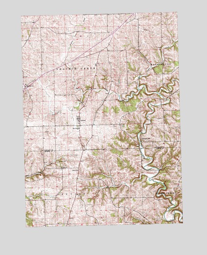
Bernard, IA USGS Topographic Map
Click on map above to begin viewing in our Map Viewer.

This topographic map contains these locations and features:
Feature Name Type Latitude Longitude GNIS ID View Map
BernardPopulated PlaceN42.3122°W90.8318°454528View Map
Bernard (historical)LocaleN42.3100°W90.8307°2001380View Map
Bernard Elementary SchoolSchoolN42.3075°W90.8309°462841View Map
Bernard Fire DepartmentBuildingN42.3142°W90.8311°2001379View Map
Bernard Post OfficePost OfficeN42.3122°W90.8318°2001377View Map
Bernard Town HallBuildingN42.3122°W90.8318°2001378View Map
Buncombe CreekStreamN42.3270°W90.7660°454979View Map
City of BernardCivilN42.3132°W90.8317°2394148View Map
Donelan POst Office (historical)Post OfficeN42.3333°W90.8501°2001424View Map
Garry OwenPopulated PlaceN42.2833°W90.8318°464556View Map
Garry Owen Post Office (historical)Post OfficeN42.2833°W90.8318°2000900View Map
Melleray (historical)LocaleN42.3667°W90.8418°466224View Map
Melleray Post Office (historical)Post OfficeN42.3167°W90.8335°2001428View Map
Prairie CreekStreamN42.3286°W90.7826°460405View Map
Prairie Creek Post Office (historical)Post OfficeN42.3083°W90.8210°2001427View Map
Sacred Heart CemeteryCemeteryN42.3343°W90.8712°2001510View Map
Sacred Heart ChurchChurchN42.3333°W90.8732°2001376View Map
Sacred Heart SchoolSchoolN42.3342°W90.8729°460905View Map
Saint Patrick SchoolSchoolN42.2847°W90.8462°461241View Map
Saint Patrick's CemeteryCemeteryN42.2883°W90.8485°461237View Map
Saint Patricks ChurchChurchN42.2853°W90.8471°2001081View Map
Theisen CreekStreamN42.3290°W90.8074°2558101View Map
Township of ButlerCivilN42.2508°W90.8400°467515View Map
Township of Prairie CreekCivilN42.3386°W90.8399°468574View Map
Washington Mill BridgeBridgeN42.3042°W90.7807°2001443View Map
Washington MillsPopulated PlaceN42.3006°W90.7824°464793View Map
Washington Mills Post Office (historical)Post OfficeN42.3006°W90.7824°2001426View Map

Note: Coordinates in the location and feature list above are referenced to NAD83 datum.


Copyright (C) 2008-2025 Ryan Niemi / Sunset Dynamics ... All Rights Reserved