TopoQuest Logo
Do you find TopoQuest useful?
Help keep TopoQuest running and adding new maps/features by donating!
Bitcoin:  19c7KJd3qBynnjoSw5npx9KScwjBe4ifkT
Litecoin:  LXs6TkuXGGXo1vDsWCkWVdjQX94eUKd6ui
Home View Maps Find Maps Find Places Resources & Links


Underwood, Minnesota Topographic Map

USGS Map Title: Underwood, MN
USGS Map MRC: 46095C7
DRG (GeoTIFF) Download: o46095c7.tif


Neighboring USGS Topographic Map Quads:


  Heilberger Lake, MN  
46095D8
 

  Phelps, MN  
46095D7
 

  Walker Lake, MN  
46095D6
 

  Wall Lake, MN  
46095C8
 

  Underwood, MN  
46095C7
 

  Battle Lake, MN  
46095C6
 

  Dalton, MN  
46095B8
 

  Stalker Lake, MN  
46095B7
 

  Eagle Lake, MN  
46095B6


Map MRC Location:

N47°
W96°
N47°
W95°
H8 H7 H6 H5 H4 H3 H2 H1
G8 G7 G6 G5 G4 G3 G2 G1
F8 F7 F6 F5 F4 F3 F2 F1
E8 E7 E6 E5 E4 E3 E2 E1
D8 D7 D6 D5 D4 D3 D2 D1
C8 C7 C6 C5 C4 C3 C2 C1
B8 B7 B6 B5 B4 B3 B2 B1
A8 A7 A6 A5 A4 A3 A2 A1
N46°
W96°
N46°
W95°

Underwood, MN USGS 1:24K Topographic Map Preview:
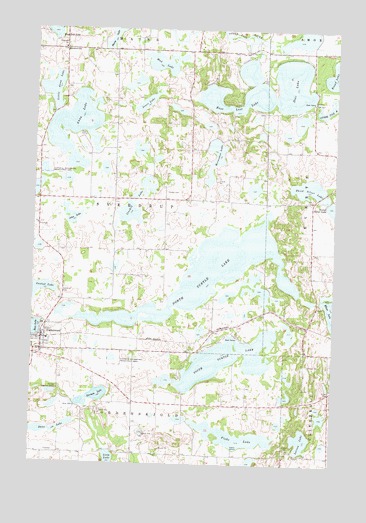
Underwood, MN USGS Topographic Map
Click on map above to begin viewing in our Map Viewer.

This topographic map contains these locations and features:
Feature Name Type Latitude Longitude GNIS ID View Map
Anna LakeLakeN46.3479°W95.8586°639386View Map
Barnhard SchoolSchoolN46.3686°W95.8631°639641View Map
City of UnderwoodCivilN46.2869°W95.8723°2397082View Map
Crooked LakeLakeN46.3219°W95.8356°642461View Map
Dane LakeLakeN46.2595°W95.8742°642616View Map
Deer LakeLakeN46.3595°W95.7684°642721View Map
East Lost LakeLakeN46.3583°W95.7799°643091View Map
Fiske LakeLakeN46.2582°W95.7903°643712View Map
Foss Log CabinBuildingN46.2883°W95.8672°2073070View Map
German LakeLakeN46.2693°W95.8491°644097View Map
Horseshoe LakeLakeN46.3383°W95.8003°645225View Map
John LakeLakeN46.3210°W95.8593°645668View Map
Jones LakeLakeN46.3538°W95.8293°645729View Map
Larson LakeLakeN46.2572°W95.7623°646504View Map
Little Anna LakeLakeN46.3573°W95.8678°646746View Map
Messiah Lutheran ChurchChurchN46.2853°W95.8706°2073068View Map
Mud LakeLakeN46.3651°W95.8235°648295View Map
North Turtle LakeLakeN46.3046°W95.8033°648703View Map
Norwegian Methodist Episcopal Church CemeteryCemeteryN46.2556°W95.8411°2071827View Map
Onstad LakeLakeN46.2999°W95.8723°648974View Map
Rindal CemeteryCemeteryN46.3283°W95.8203°650086View Map
School Number 109 (historical)SchoolN46.3186°W95.8736°2128753View Map
School Number 112 (historical)SchoolN46.3228°W95.8172°2128754View Map
School Number 146 (historical)SchoolN46.3686°W95.8011°2128749View Map
School Number 162 (historical)SchoolN46.2525°W95.8067°2128757View Map
School Number 231 (historical)SchoolN46.2825°W95.8317°2128758View Map
School Number 257 (historical)SchoolN46.2767°W95.7611°2128756View Map
School Number 270 (historical)SchoolN46.3111°W95.7589°2128755View Map
South Turtle LakeLakeN46.2803°W95.7938°652348View Map
Sunset Memorial Unitarian CemeteryCemeteryN46.2892°W95.8706°2071828View Map
Sverdrup CemeteryCemeteryN46.2991°W95.8628°652873View Map
Sverdrup Lutheran ChurchChurchN46.2867°W95.8706°2073071View Map
Third Silver LakeLakeN46.3298°W95.7614°653138View Map
Tingvold CemeteryCemeteryN46.3694°W95.8639°2072676View Map
Tingvold ChurchChurchN46.3694°W95.8639°653214View Map
Township of SverdrupCivilN46.3262°W95.8414°665747View Map
UnderwoodPopulated PlaceN46.2852°W95.8709°653489View Map
Underwood (historical)LocaleN46.2853°W95.8717°2073069View Map
Underwood Fire DepartmentBuildingN46.2857°W95.8702°2666541View Map
Underwood High SchoolSchoolN46.2819°W95.8708°2073072View Map
Underwood Post Office (historical)Post OfficeN46.2853°W95.8706°2073067View Map
Unitarian Church of UnderwoodChurchN46.2853°W95.8706°2073066View Map

Note: Coordinates in the location and feature list above are referenced to NAD83 datum.


Copyright (C) 2008-2025 Ryan Niemi / Sunset Dynamics ... All Rights Reserved