TopoQuest Logo
Do you find TopoQuest useful?
Help keep TopoQuest running and adding new maps/features by donating!
Bitcoin:  19c7KJd3qBynnjoSw5npx9KScwjBe4ifkT
Litecoin:  LXs6TkuXGGXo1vDsWCkWVdjQX94eUKd6ui
Home View Maps Find Maps Find Places Resources & Links


Columbia South, Mississippi Topographic Map

USGS Map Title: Columbia South, MS
USGS Map MRC: 31089B7
DRG (GeoTIFF) Download: o31089b7.tif


Neighboring USGS Topographic Map Quads:


  Morgantown, MS  
31089C8
 

  Columbia North, MS  
31089C7
 

  Improve, MS  
31089C6
 

  Sandy Hook NW, MS  
31089B8
 

  Columbia South, MS  
31089B7
 

  Pinebur, MS  
31089B6
 

  Dexter, MS  
31089A8
 

  Sandy Hook, MS  
31089A7
 

  Baxterville SW, MS  
31089A6


Map MRC Location:

N32°
W90°
N32°
W89°
H8 H7 H6 H5 H4 H3 H2 H1
G8 G7 G6 G5 G4 G3 G2 G1
F8 F7 F6 F5 F4 F3 F2 F1
E8 E7 E6 E5 E4 E3 E2 E1
D8 D7 D6 D5 D4 D3 D2 D1
C8 C7 C6 C5 C4 C3 C2 C1
B8 B7 B6 B5 B4 B3 B2 B1
A8 A7 A6 A5 A4 A3 A2 A1
N31°
W90°
N31°
W89°

Columbia South, MS USGS 1:24K Topographic Map Preview:
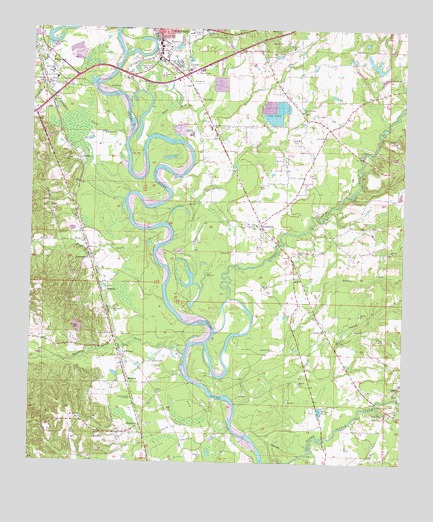
Columbia South, MS USGS Topographic Map
Click on map above to begin viewing in our Map Viewer.

This topographic map contains these locations and features:
Feature Name Type Latitude Longitude GNIS ID View Map
Antioch CemeteryCemeteryN31.2193°W89.7765°710511View Map
Antioch ChurchChurchN31.2193°W89.7773°666297View Map
Balls Mill CreekStreamN31.2185°W89.8370°666497View Map
Bayliss Water Mill (historical)LocaleN31.1966°W89.7795°710513View Map
CherawPopulated PlaceN31.1557°W89.8434°668362View Map
Christian Hill Baptist ChurchChurchN31.2402°W89.8726°689726View Map
Church of ChristChurchN31.2496°W89.8167°689655View Map
Church of God in ChristChurchN31.1432°W89.8406°668476View Map
Columbia Fire Department Station 2BuildingN31.2486°W89.8227°2667931View Map
Columbia Sewage Lagoon DamDamN31.2385°W89.8167°680625View Map
Dillon CreekStreamN31.1416°W89.8059°669269View Map
Duckworth ParkParkN31.2380°W89.8248°689668View Map
East Columbia CemeteryCemeteryN31.2263°W89.7837°710526View Map
East Columbia ChurchChurchN31.2266°W89.7851°669565View Map
EdnaPopulated PlaceN31.1771°W89.7862°710529View Map
Edna ChurchChurchN31.1777°W89.7862°669677View Map
Edna School (historical)SchoolN31.1785°W89.7859°710530View Map
FoxworthPopulated PlaceN31.2382°W89.8687°670151View Map
Foxworth Fire DepartmentBuildingN31.2342°W89.8724°2667722View Map
Foxworth First Baptist ChurchChurchN31.2377°W89.8684°689673View Map
Foxworth Post OfficePost OfficeN31.2343°W89.8671°2596834View Map
Friendship CemeteryCemeteryN31.2443°W89.7884°710538View Map
Friendship ChurchChurchN31.2449°W89.7890°670215View Map
Friendship School (historical)SchoolN31.2449°W89.7848°710584View Map
Gardner StadiumParkN31.2491°W89.8195°689674View Map
HubPopulated PlaceN31.1455°W89.7501°691947View Map
Hub Attendance CenterSchoolN31.1480°W89.7506°710550View Map
Hub ChurchChurchN31.1405°W89.7515°671540View Map
Hub Oil FieldOilfieldN31.1335°W89.8070°689677View Map
JamestownPopulated PlaceN31.1835°W89.8554°691964View Map
Keno (historical)Populated PlaceN31.2002°W89.7787°710555View Map
LamptonPopulated PlaceN31.1932°W89.7981°672291View Map
LovelacePopulated PlaceN31.2124°W89.8592°692023View Map
Macedonia ChurchChurchN31.1638°W89.7754°672998View Map
Marion - Walthall County / Regional Correctional FacilityBuildingN31.2497°W89.8367°2739805View Map
Marion CountyCivilN31.2308°W89.8224°695769View Map
Marion County High SchoolSchoolN31.2196°W89.8215°689685View Map
Marion County Vocational SchoolSchoolN31.2216°W89.8154°689687View Map
Mays CreekStreamN31.1721°W89.8304°673279View Map
MildredPopulated PlaceN31.1480°W89.8420°692073View Map
Mount Carmel ChurchChurchN31.1377°W89.8573°673953View Map
NatcolePopulated PlaceN31.1741°W89.8498°692098View Map
New BridgeBridgeN31.2385°W89.8473°689689View Map
New Zion CemeteryCemeteryN31.1938°W89.7990°689690View Map
New Zion MethodistChurchN31.1935°W89.7990°689691View Map
Old Bridge (historical)BridgeN31.2318°W89.8534°689695View Map
PickwickPopulated PlaceN31.1357°W89.8376°692140View Map
Porter AirportAirportN31.1752°W89.8063°2676406View Map
Saint Paul ChurchChurchN31.1449°W89.8320°677181View Map
Saint Paul School (historical)SchoolN31.1455°W89.8329°689699View Map
Sanctified Church (historical)ChurchN31.2007°W89.7873°689701View Map
Silver CreekStreamN31.2185°W89.8440°677794View Map
Singley Ponds DamDamN31.2252°W89.7917°680622View Map
Star B Rest Personal Care HomeBuildingN31.1935°W89.7595°2596202View Map
Sunflower CemeteryCemeteryN31.1685°W89.8476°710576View Map
Sunflower ChurchChurchN31.1688°W89.8476°678414View Map
Sweet Valley ChurchChurchN31.1391°W89.7548°678487View Map
Tenmile CreekStreamN31.1499°W89.8223°678625View Map
True Vine Baptist ChurchChurchN31.2493°W89.8356°689707View Map
Upper Little CreekStreamN31.1621°W89.8145°679152View Map
Water Valley School (historical)SchoolN31.2405°W89.8717°710578View Map
WCJU-AM (Columbia)TowerN31.2374°W89.8401°680072View Map
West Columbia Church of GodChurchN31.2382°W89.8690°689711View Map
West Marion Primary SchoolSchoolN31.2357°W89.8673°710580View Map
Woodlawn CemeteryCemeteryN31.2500°W89.7911°679855View Map
Zion Hill Church (historical)ChurchN31.1363°W89.7770°689716View Map

Note: Coordinates in the location and feature list above are referenced to NAD83 datum.


Copyright (C) 2008-2025 Ryan Niemi / Sunset Dynamics ... All Rights Reserved