TopoQuest Logo
Do you find TopoQuest useful?
Help keep TopoQuest running and adding new maps/features by donating!
Bitcoin:  19c7KJd3qBynnjoSw5npx9KScwjBe4ifkT
Litecoin:  LXs6TkuXGGXo1vDsWCkWVdjQX94eUKd6ui
Home View Maps Find Maps Find Places Resources & Links


Randle, Ohio Topographic Map

USGS Map Title: Randle, OH
USGS Map MRC: 40081C8
DRG (GeoTIFF) Download: o40081c8.tif


Neighboring USGS Topographic Map Quads:


  Spring Mountain, OH  
40082D1
 

  Killbuck, OH  
40081D8
 

  New Bedford, OH  
40081D7
 

  Warsaw, OH  
40082C1
 

  Randle, OH  
40081C8
 

  Coshocton, OH  
40081C7
 

  Trinway, OH  
40082B1
 

  Conesville, OH  
40081B8
 

  Wills Creek, OH  
40081B7


Map MRC Location:

N41°
W82°
N41°
W81°
H8 H7 H6 H5 H4 H3 H2 H1
G8 G7 G6 G5 G4 G3 G2 G1
F8 F7 F6 F5 F4 F3 F2 F1
E8 E7 E6 E5 E4 E3 E2 E1
D8 D7 D6 D5 D4 D3 D2 D1
C8 C7 C6 C5 C4 C3 C2 C1
B8 B7 B6 B5 B4 B3 B2 B1
A8 A7 A6 A5 A4 A3 A2 A1
N40°
W82°
N40°
W81°

Randle, OH USGS 1:24K Topographic Map Preview:
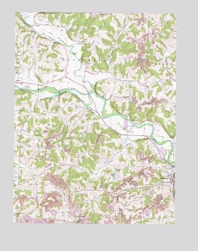
Randle, OH USGS Topographic Map
Click on map above to begin viewing in our Map Viewer.

This topographic map contains these locations and features:
Feature Name Type Latitude Longitude GNIS ID View Map
Antioch CemeteryCemeteryN40.3047°W81.9928°1037445View Map
Apache Number 1 PitMineN40.2944°W81.8833°2649416View Map
Bantum School (historical)SchoolN40.3367°W81.9593°1050315View Map
Blooming Grove CemeteryCemeteryN40.3020°W81.9842°1038123View Map
Bucklew RunStreamN40.3295°W81.9385°1066614View Map
Christian Apostolic ChurchChurchN40.2798°W81.8765°1806944View Map
Coshocton CountyCivilN40.3016°W81.9200°1074028View Map
Crooked RunStreamN40.3006°W81.8937°1066667View Map
Crooked Run Cross RoadsLocaleN40.2862°W81.9282°1067512View Map
Dickerson Mobile Home ParkPopulated PlaceN40.3061°W81.8911°2680518View Map
Edgewood TerracePopulated PlaceN40.3006°W81.9017°2680521View Map
Jackson Township Fire StationBuildingN40.2740°W81.8865°2550471View Map
Johnson-Humrickhouse MuseumBuildingN40.2770°W81.8771°1806954View Map
Killbuck CreekStreamN40.3290°W81.9374°1066785View Map
Marshall School (historical)SchoolN40.2542°W81.9965°1050312View Map
MethamPopulated PlaceN40.3678°W81.9849°1062890View Map
Metham Post Office (historical)Post OfficeN40.3681°W81.9846°1967437View Map
Mill CreekStreamN40.2940°W81.8776°1043315View Map
Mount Zion ChurchChurchN40.3562°W81.9482°1043661View Map
Pinfeather RidgeRidgeN40.3634°W81.9351°1044478View Map
Pleasant Hill Baptist CemeteryCemeteryN40.2548°W81.9496°1964130View Map
Pleasant Hill ChurchChurchN40.2542°W81.9496°1044557View Map
Prairie Chapel CemeteryCemeteryN40.3051°W81.9132°1964132View Map
Prairie Chapel United Methodist ChurchChurchN40.3048°W81.9129°1065240View Map
RandlePopulated PlaceN40.3134°W81.9332°1061583View Map
River View High SchoolSchoolN40.3395°W81.9590°1050316View Map
RoscoePopulated PlaceN40.2773°W81.8793°1065537View Map
Roscoe BasinBasinN40.2845°W81.8762°1057968View Map
Roscoe CemeteryCemeteryN40.2820°W81.8851°1964134View Map
Roscoe Post Office (historical)Post OfficeN40.2778°W81.8790°1967615View Map
Roscoe School (historical)SchoolN40.2787°W81.8801°1806958View Map
Roscoe United Methodist ChurchChurchN40.2770°W81.8787°1069964View Map
School Number 1 (historical)SchoolN40.3609°W81.9860°1050317View Map
School Number 1 (historical)SchoolN40.2678°W81.9201°1050318View Map
School Number 3 (historical)SchoolN40.3573°W81.9490°1050320View Map
School Number 4 (historical)SchoolN40.2806°W81.9765°1050313View Map
School Number 5 (historical)SchoolN40.3626°W81.9193°1050321View Map
School Number 5 (historical)SchoolN40.3181°W81.8754°1050322View Map
School Number 5 (historical)SchoolN40.2951°W81.9662°1050392View Map
School Number 6 (historical)SchoolN40.2876°W81.9271°1050319View Map
School Number 7 (historical)SchoolN40.3284°W81.9107°1050323View Map
Simmons RunStreamN40.3298°W81.9974°1066958View Map
Six Mile ReservoirReservoirN40.3284°W81.9649°1078636View Map
Sixmile DamDamN40.3276°W81.9651°1058019View Map
Soggy Hill School (historical)SchoolN40.3159°W81.9707°1050314View Map
Sunset LakeReservoirN40.2786°W81.9215°1077672View Map
Sunset Lake DamDamN40.2801°W81.9215°1077671View Map
Three Rivers HeliportAirportN40.2709°W81.8771°1082221View Map
Township of BethlehemCivilN40.3404°W81.9457°1085911View Map
Township of JacksonCivilN40.2659°W81.9367°1085916View Map
TyronePopulated PlaceN40.2528°W81.9779°1063070View Map
Tyrone Post Office (historical)Post OfficeN40.2528°W81.9776°1967456View Map
Walhonding CanalCanalN40.3220°W81.9471°1047500View Map
White Womans RockPillarN40.3115°W81.9099°1067055View Map
White Womans Town (historical)Populated PlaceN40.3262°W81.9393°1067518View Map

Note: Coordinates in the location and feature list above are referenced to NAD83 datum.


Copyright (C) 2008-2024 Ryan Niemi / Sunset Dynamics ... All Rights Reserved