TopoQuest Logo
Do you find TopoQuest useful?
Help keep TopoQuest running and adding new maps/features by donating!
Bitcoin:  19c7KJd3qBynnjoSw5npx9KScwjBe4ifkT
Litecoin:  LXs6TkuXGGXo1vDsWCkWVdjQX94eUKd6ui
Home View Maps Find Maps Find Places Resources & Links


Warsaw, Ohio Topographic Map

USGS Map Title: Warsaw, OH
USGS Map MRC: 40082C1
DRG (GeoTIFF) Download: o40082c1.tif


Neighboring USGS Topographic Map Quads:


  Brinkhaven, OH  
40082D2
 

  Spring Mountain, OH  
40082D1
 

  Killbuck, OH  
40081D8
 

  Walhonding, OH  
40082C2
 

  Warsaw, OH  
40082C1
 

  Randle, OH  
40081C8
 

  Perryton, OH  
40082B2
 

  Trinway, OH  
40082B1
 

  Conesville, OH  
40081B8


Map MRC Location:

N41°
W83°
N41°
W82°
H8 H7 H6 H5 H4 H3 H2 H1
G8 G7 G6 G5 G4 G3 G2 G1
F8 F7 F6 F5 F4 F3 F2 F1
E8 E7 E6 E5 E4 E3 E2 E1
D8 D7 D6 D5 D4 D3 D2 D1
C8 C7 C6 C5 C4 C3 C2 C1
B8 B7 B6 B5 B4 B3 B2 B1
A8 A7 A6 A5 A4 A3 A2 A1
N40°
W83°
N40°
W82°

Warsaw, OH USGS 1:24K Topographic Map Preview:
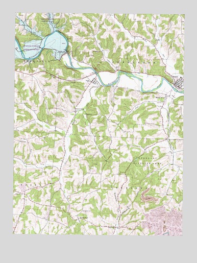
Warsaw, OH USGS Topographic Map
Click on map above to begin viewing in our Map Viewer.

This topographic map contains these locations and features:
Feature Name Type Latitude Longitude GNIS ID View Map
Beaver RunStreamN40.3320°W82.0004°1037765View Map
Bluff (historical)Populated PlaceN40.3501°W82.1165°1067510View Map
Bluff Post Office (historical)Post OfficeN40.3500°W82.1164°1967613View Map
Brush College School (historical)SchoolN40.2692°W82.0476°1050306View Map
Darling RunStreamN40.3426°W82.0474°1066671View Map
Darling Run ChurchChurchN40.3534°W82.0610°1039585View Map
Darling Run School (historical)SchoolN40.3581°W82.0643°1050307View Map
Donley School (historical)SchoolN40.2915°W82.0218°1050308View Map
Dutch RunStreamN40.3651°W82.0946°1039905View Map
First Baptist Church of DaytonChurchN40.2695°W82.0440°1065552View Map
Flint RunStreamN40.3198°W82.0110°1040530View Map
Goshen CemeteryCemeteryN40.2728°W82.1193°1964111View Map
Goshen ChurchChurchN40.2728°W82.1199°1040978View Map
Goshen School (historical)SchoolN40.2623°W82.1179°1050302View Map
Honey RunStreamN40.3603°W82.1015°1041729View Map
Honey Run CemeteryCemeteryN40.3713°W82.1175°1041743View Map
Honey Run School (historical)SchoolN40.3645°W82.1132°1050305View Map
Jefferson Presbyterian CemeteryCemeteryN40.3200°W82.0166°1964113View Map
Jefferson School (historical)SchoolN40.3167°W82.0151°1050309View Map
Mikesell CemeteryCemeteryN40.2881°W82.0963°1964119View Map
Mohawk CemeteryCemeteryN40.3184°W82.0726°1964122View Map
Mohawk ChurchChurchN40.3181°W82.0721°1043427View Map
Mohawk CreekStreamN40.3348°W82.0599°1063511View Map
Mohawk DamDamN40.3517°W82.0899°1077637View Map
Mohawk ReservoirReservoirN40.3517°W82.0899°1077638View Map
Mohawk VillagePopulated PlaceN40.3251°W82.0796°1043428View Map
Mohawk Village Post Office (historical)Post OfficeN40.3251°W82.0790°1967439View Map
Nebo School (historical)SchoolN40.3395°W82.1110°1050304View Map
Neldon School (historical)SchoolN40.2912°W82.1185°1050303View Map
NelliePopulated PlaceN40.3365°W82.0679°1065101View Map
Nellie CemeteryCemeteryN40.3436°W82.0505°1043797View Map
Nellie Post Office (historical)Post OfficeN40.3362°W82.0679°1967442View Map
Opossum HollowValleyN40.3378°W82.0738°1066876View Map
Tarkiln School (historical)SchoolN40.3626°W82.0221°1050311View Map
Township of BedfordCivilN40.2691°W82.0468°1085910View Map
Township of JeffersonCivilN40.3420°W82.0430°1085917View Map
Tunnel HillPopulated PlaceN40.2548°W82.0490°1061713View Map
Tunnel Hill Post Office (historical)Post OfficeN40.2542°W82.0485°1967455View Map
Valley View CemeteryCemeteryN40.3255°W82.0135°1047406View Map
Village of NellieCivilN40.3385°W82.0707°2399442View Map
Village of WarsawCivilN40.3355°W82.0015°2400096View Map
Walhonding Valley Fire DepartmentBuildingN40.3346°W82.0065°2550095View Map
WarsawPopulated PlaceN40.3353°W82.0068°1049292View Map
Warsaw Elementary SchoolSchoolN40.3395°W82.0021°1050310View Map
Warsaw JunctionPopulated PlaceN40.3290°W82.0121°1065455View Map
Warsaw Post OfficePost OfficeN40.3365°W82.0057°1964094View Map
West BedfordPopulated PlaceN40.2592°W82.0765°1061733View Map
West Bedford CemeteryCemeteryN40.2637°W82.0737°1047731View Map
West Bedford Number 2 CemeteryCemeteryN40.2554°W82.0735°1964147View Map
West Bedford Post Office (historical)Post OfficeN40.2598°W82.0763°1967458View Map
Wilson ChapelChurchN40.3023°W82.1213°1047980View Map
Wilson Chapel CemeteryCemeteryN40.3020°W82.1210°1964149View Map
Woodbury Wildlife AreaParkN40.2923°W82.0313°1048070View Map
Zion Evangelical Lutheran CemeteryCemeteryN40.3616°W82.0165°1964151View Map

Note: Coordinates in the location and feature list above are referenced to NAD83 datum.


Copyright (C) 2008-2024 Ryan Niemi / Sunset Dynamics ... All Rights Reserved