TopoQuest Logo
Do you find TopoQuest useful?
Help keep TopoQuest running and adding new maps/features by donating!
Bitcoin:  19c7KJd3qBynnjoSw5npx9KScwjBe4ifkT
Litecoin:  LXs6TkuXGGXo1vDsWCkWVdjQX94eUKd6ui
Home View Maps Find Maps Find Places Resources & Links


Red Point, Utah Topographic Map

USGS Map Title: Red Point, UT
USGS Map MRC: 39111C1
DRG (GeoTIFF) Download: o39111c1.tif


Neighboring USGS Topographic Map Quads:


  Rilda Canyon, UT  
39111D2
 

  Hiawatha, UT  
39111D1
 

  Poison Spring Bench, UT  
39110D8
 

  Mahogany Point, UT  
39111C2
 

  Red Point, UT  
39111C1
 

  Huntington, UT  
39110C8
 

  The Cap, UT  
39111B2
 

  Castle Dale, UT  
39111B1
 

  Hadden Holes, UT  
39110B8


Map MRC Location:

N40°
W112°
N40°
W111°
H8 H7 H6 H5 H4 H3 H2 H1
G8 G7 G6 G5 G4 G3 G2 G1
F8 F7 F6 F5 F4 F3 F2 F1
E8 E7 E6 E5 E4 E3 E2 E1
D8 D7 D6 D5 D4 D3 D2 D1
C8 C7 C6 C5 C4 C3 C2 C1
B8 B7 B6 B5 B4 B3 B2 B1
A8 A7 A6 A5 A4 A3 A2 A1
N39°
W112°
N39°
W111°

Red Point, UT USGS 1:24K Topographic Map Preview:
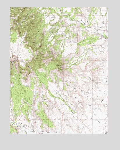
Red Point, UT USGS Topographic Map
Click on map above to begin viewing in our Map Viewer.

This topographic map contains these locations and features:
Feature Name Type Latitude Longitude GNIS ID View Map
Anderson MineMineN39.3105°W111.1132°1438218View Map
Bony BenchBenchN39.2833°W111.0404°1439001View Map
Brockbank HollowValleyN39.3586°W111.0291°1439150View Map
Chris Otteson HollowValleyN39.3544°W111.0029°1438079View Map
Clipper Western CanalCanalN39.2566°W111.1149°1439815View Map
Cottonwood Creek Huntington CanalCanalN39.2539°W111.0893°1440021View Map
Cottonwood Creek Huntington CanalCanalN39.2852°W111.0054°1440022View Map
Danish BenchBenchN39.2608°W111.0346°1440261View Map
Deer Creek MineMineN39.3572°W111.1166°1440375View Map
Des-Bee-Drive MineMineN39.3161°W111.1016°1450187View Map
Elk CanyonValleyN39.3586°W111.1118°1440899View Map
Fish CreekStreamN39.3655°W111.0488°1441074View Map
Green FlatFlatN39.3491°W111.0463°1448443View Map
Maple GulchValleyN39.3647°W111.0516°1443168View Map
Racehorse FlatFlatN39.3636°W111.0704°1444706View Map
Red PointCapeN39.3172°W111.0621°1444829View Map
Rowley FlatFlatN39.3325°W111.0110°1448945View Map
Stump FlatFlatN39.3483°W111.0677°1446203View Map
Wilberg FlatFlatN39.2619°W111.0110°1447338View Map
Wilberg MineMineN39.3211°W111.1229°1447339View Map
Wilberg Mine MemorialLocaleN39.2561°W111.0968°1453040View Map

Note: Coordinates in the location and feature list above are referenced to NAD83 datum.


Copyright (C) 2008-2024 Ryan Niemi / Sunset Dynamics ... All Rights Reserved