TopoQuest Logo
Do you find TopoQuest useful?
Help keep TopoQuest running and adding new maps/features by donating!
Bitcoin:  19c7KJd3qBynnjoSw5npx9KScwjBe4ifkT
Litecoin:  LXs6TkuXGGXo1vDsWCkWVdjQX94eUKd6ui
Home View Maps Find Maps Find Places Resources & Links


Castle Dale, Utah Topographic Map

USGS Map Title: Castle Dale, UT
USGS Map MRC: 39111B1
DRG (GeoTIFF) Download: o39111b1.tif


Neighboring USGS Topographic Map Quads:


  Mahogany Point, UT  
39111C2
 

  Red Point, UT  
39111C1
 

  Huntington, UT  
39110C8
 

  The Cap, UT  
39111B2
 

  Castle Dale, UT  
39111B1
 

  Hadden Holes, UT  
39110B8
 

  Ferron, UT  
39111A2
 

  Molen, UT  
39111A1
 

  Horn Silver Gulch, UT  
39110A8


Map MRC Location:

N40°
W112°
N40°
W111°
H8 H7 H6 H5 H4 H3 H2 H1
G8 G7 G6 G5 G4 G3 G2 G1
F8 F7 F6 F5 F4 F3 F2 F1
E8 E7 E6 E5 E4 E3 E2 E1
D8 D7 D6 D5 D4 D3 D2 D1
C8 C7 C6 C5 C4 C3 C2 C1
B8 B7 B6 B5 B4 B3 B2 B1
A8 A7 A6 A5 A4 A3 A2 A1
N39°
W112°
N39°
W111°

Castle Dale, UT USGS 1:24K Topographic Map Preview:
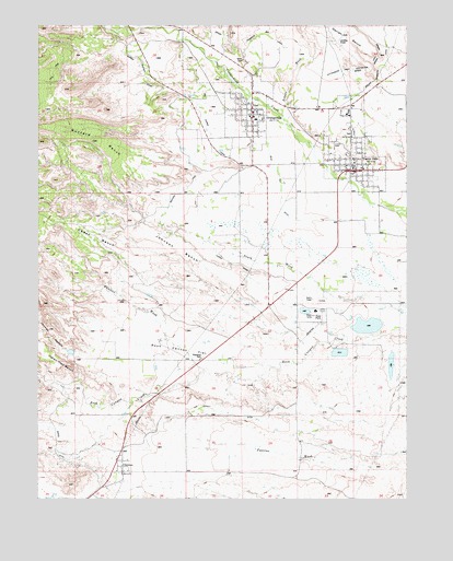
Castle Dale, UT USGS Topographic Map
Click on map above to begin viewing in our Map Viewer.

This topographic map contains these locations and features:
Feature Name Type Latitude Longitude GNIS ID View Map
Blackburns RanchLocaleN39.1494°W111.1182°1425736View Map
Blue Cut DitchCanalN39.2389°W111.0632°1425793View Map
Bolden WashValleyN39.2286°W111.0429°1438992View Map
Buzzard BenchBenchN39.2166°W111.1013°1426239View Map
Castle DalePopulated PlaceN39.2122°W111.0196°1426380View Map
Castle Dale City CemeteryCemeteryN39.2214°W111.0204°1435261View Map
Castle Dale Elementary SchoolSchoolN39.2211°W111.0164°1435262View Map
Castle Dale Fire DepartmentBuildingN39.2135°W111.0189°2627149View Map
Castle Dale Post OfficePost OfficeN39.2108°W111.0203°2769046View Map
Cedar BenchBenchN39.1975°W111.1210°1439554View Map
City of Castle DaleCivilN39.2218°W111.0230°2409407View Map
City of OrangevilleCivilN39.2308°W111.0592°2411329View Map
ClawsonPopulated PlaceN39.1330°W111.0971°1426675View Map
Clawson CemeteryCemeteryN39.1266°W111.1099°2769387View Map
Clawson Post OfficePost OfficeN39.1320°W111.0971°2769048View Map
Clipper CanalCanalN39.2005°W111.0688°1435320View Map
Cottonwood Elementary SchoolSchoolN39.2252°W111.0519°1435355View Map
Dooley DitchCanalN39.1475°W111.0604°1435440View Map
Emery County Ambulance Castle DaleBuildingN39.2125°W111.0212°2768440View Map
Emery County JailBuildingN39.2434°W111.0272°2769016View Map
Emery County Sheriff's Office Castle DaleBuildingN39.2433°W111.0270°2730433View Map
Emery DamDamN39.1633°W111.0124°1434731View Map
Emery High SchoolSchoolN39.2278°W111.0215°1435507View Map
Emery Medical CenterHospitalN39.2124°W111.0211°2769001View Map
Emery Plant DamDamN39.1666°W111.0091°1434733View Map
Emery Plant ReservoirReservoirN39.1666°W111.0091°1434732View Map
Fox RanchLocaleN39.2439°W111.0879°1428078View Map
Grimes WashValleyN39.2491°W111.0918°1441500View Map
Indian Trail BenchBenchN39.1602°W111.1185°1442036View Map
Jewkes HollowValleyN39.1625°W111.1124°1442140View Map
Johnson BenchBenchN39.1902°W111.0749°1429212View Map
North DitchCanalN39.1400°W111.1149°1436040View Map
OrangevillePopulated PlaceN39.2272°W111.0535°1431021View Map
Orangeville CemeteryCemeteryN39.2316°W111.0693°1437265View Map
Orangeville Fire DepartmentBuildingN39.2215°W111.0536°2627133View Map
Orangeville Post OfficePost OfficeN39.2229°W111.0535°2769034View Map
Paulson WashValleyN39.1800°W111.1079°1436107View Map
Rock Canyon FlatFlatN39.1639°W111.0907°1431902View Map
The Church of Jesus Christ of Latter Day SaintsChurchN39.2258°W111.0541°1437025View Map
The Church of Jesus Christ of Latter Day SaintsChurchN39.2122°W111.0191°1436845View Map
The Church of Jesus Christ of Latter Day SaintsChurchN39.2230°W111.0207°1436846View Map
Town of ClawsonCivilN39.1324°W111.0989°2413208View Map
Utah Power and Light Ash ReservoirReservoirN39.1633°W111.0124°1434730View Map
Western DitchCanalN39.2216°W111.0785°1434129View Map
Wilberg MemorialParkN39.1958°W111.0216°1436642View Map

Note: Coordinates in the location and feature list above are referenced to NAD83 datum.


Copyright (C) 2008-2025 Ryan Niemi / Sunset Dynamics ... All Rights Reserved