TopoQuest Logo
Do you find TopoQuest useful?
Help keep TopoQuest running and adding new maps/features by donating!
Bitcoin:  19c7KJd3qBynnjoSw5npx9KScwjBe4ifkT
Litecoin:  LXs6TkuXGGXo1vDsWCkWVdjQX94eUKd6ui
Home View Maps Find Maps Find Places Resources & Links


Saint Elizabeth, Missouri Topographic Map

USGS Map Title: Saint Elizabeth, MO
USGS Map MRC: 38092C3
DRG (GeoTIFF) Download: o38092c3.tif


Neighboring USGS Topographic Map Quads:


  Enon, MO  
38092D4
 

  Brazito, MO  
38092D3
 

  Wardsville, MO  
38092D2
 

  Eugene, MO  
38092C4
 

  Saint Elizabeth, MO  
38092C3
 

  Meta, MO  
38092C2
 

  Tuscumbia, MO  
38092B4
 

  Saint Anthony, MO  
38092B3
 

  Van Cleve, MO  
38092B2


Map MRC Location:

N39°
W93°
N39°
W92°
H8 H7 H6 H5 H4 H3 H2 H1
G8 G7 G6 G5 G4 G3 G2 G1
F8 F7 F6 F5 F4 F3 F2 F1
E8 E7 E6 E5 E4 E3 E2 E1
D8 D7 D6 D5 D4 D3 D2 D1
C8 C7 C6 C5 C4 C3 C2 C1
B8 B7 B6 B5 B4 B3 B2 B1
A8 A7 A6 A5 A4 A3 A2 A1
N38°
W93°
N38°
W92°

Saint Elizabeth, MO USGS 1:24K Topographic Map Preview:
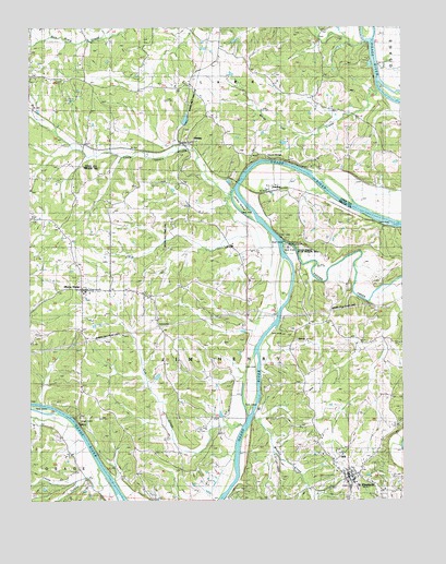
Saint Elizabeth, MO USGS Topographic Map
Click on map above to begin viewing in our Map Viewer.

This topographic map contains these locations and features:
Feature Name Type Latitude Longitude GNIS ID View Map
Bat Cave ArchArchN38.3211°W92.2922°2680494View Map
Bois Brule CreekStreamN38.3706°W92.2616°714494View Map
Cole County Fire Protection District Station 6BuildingN38.3061°W92.3561°2620551View Map
Cole County Fire Protection District Station 7BuildingN38.3703°W92.3116°2620550View Map
Cub CreekStreamN38.2692°W92.3046°716576View Map
HenleyPopulated PlaceN38.3445°W92.3224°719380View Map
Henley LakeReservoirN38.3507°W92.3228°758287View Map
Henley Lake DamDamN38.3500°W92.3235°764050View Map
Henley Natural ArchArchN38.3408°W92.2956°2680485View Map
Henley Post OfficePost OfficeN38.3444°W92.3231°2782703View Map
HoeckerPopulated PlaceN38.3320°W92.2905°740934View Map
Jenkins CemeteryCemeteryN38.3134°W92.3482°720291View Map
Jones IslandIslandN38.3278°W92.3041°720420View Map
Kempker School (historical)SchoolN38.3181°W92.3274°744528View Map
Little Tavern CreekStreamN38.3315°W92.3076°721335View Map
Lousy CreekStreamN38.2586°W92.3521°721615View Map
Marys HomePopulated PlaceN38.3056°W92.3552°729551View Map
Marys Home School (historical)SchoolN38.3070°W92.3252°721947View Map
Old Elizabeth School (historical)SchoolN38.2953°W92.2713°744529View Map
Osage-Tavern State Wildlife AreaParkN38.3164°W92.2877°742971View Map
Saint ElizabethPopulated PlaceN38.2559°W92.2680°729638View Map
Saint Elizabeth Post OfficePost OfficeN38.2557°W92.2684°2783019View Map
Saint Elizabeth Volunteer Fire DepartmentBuildingN38.2582°W92.2707°2621158View Map
Sanning School (historical)SchoolN38.2725°W92.3260°726049View Map
Spring Valley ChurchChurchN38.3545°W92.3210°726952View Map
Spring Valley School (historical)SchoolN38.3608°W92.3214°726957View Map
Spring Valley School (historical)SchoolN38.3595°W92.3280°743488View Map
Tavern CreekStreamN38.3178°W92.2899°727483View Map
Teal School (historical)SchoolN38.3420°W92.2538°727506View Map
Turkey CreekStreamN38.2553°W92.3574°727848View Map
Village of Saint ElizabethCivilN38.2561°W92.2664°2399162View Map
Whalen CreekStreamN38.2720°W92.3002°728669View Map
White Oak CreekStreamN38.3584°W92.2582°728747View Map
White Oak School (historical)SchoolN38.3600°W92.2921°743489View Map

Note: Coordinates in the location and feature list above are referenced to NAD83 datum.


Copyright (C) 2008-2025 Ryan Niemi / Sunset Dynamics ... All Rights Reserved