TopoQuest Logo
Do you find TopoQuest useful?
Help keep TopoQuest running and adding new maps/features by donating!
Bitcoin:  19c7KJd3qBynnjoSw5npx9KScwjBe4ifkT
Litecoin:  LXs6TkuXGGXo1vDsWCkWVdjQX94eUKd6ui
Home View Maps Find Maps Find Places Resources & Links


Williamsburg, Mississippi Topographic Map

USGS Map Title: Williamsburg, MS
USGS Map MRC: 31089E5
DRG (GeoTIFF) Download: o31089e5.tif


Neighboring USGS Topographic Map Quads:


  Lone Star, MS  
31089F6
 

  Collins, MS  
31089F5
 

  Hot Coffee, MS  
31089F4
 

  Lake Mike Connor, MS  
31089E6
 

  Williamsburg, MS  
31089E5
 

  Seminary, MS  
31089E4
 

  Bassfield, MS  
31089D6
 

  Sumrall, MS  
31089D5
 

  Sanford, MS  
31089D4


Map MRC Location:

N32°
W90°
N32°
W89°
H8 H7 H6 H5 H4 H3 H2 H1
G8 G7 G6 G5 G4 G3 G2 G1
F8 F7 F6 F5 F4 F3 F2 F1
E8 E7 E6 E5 E4 E3 E2 E1
D8 D7 D6 D5 D4 D3 D2 D1
C8 C7 C6 C5 C4 C3 C2 C1
B8 B7 B6 B5 B4 B3 B2 B1
A8 A7 A6 A5 A4 A3 A2 A1
N31°
W90°
N31°
W89°

Williamsburg, MS USGS 1:24K Topographic Map Preview:
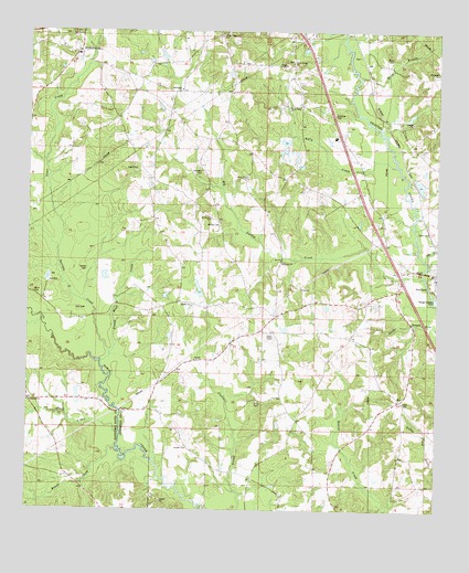
Williamsburg, MS USGS Topographic Map
Click on map above to begin viewing in our Map Viewer.

This topographic map contains these locations and features:
Feature Name Type Latitude Longitude GNIS ID View Map
Atwood Family CemeteryCemeteryN31.5292°W89.5106°2426032View Map
Big SwampSwampN31.5863°W89.5653°710614View Map
Big Swamp CreekStreamN31.5613°W89.5040°667154View Map
Bullock CemeteryCemeteryN31.5743°W89.5665°667780View Map
Caney Head CreekStreamN31.5407°W89.5995°668043View Map
Caney Head School (historical)SchoolN31.5354°W89.5773°689825View Map
Cedar Valley ChurchChurchN31.6054°W89.5459°668219View Map
Center Ridge ChurchChurchN31.6243°W89.5662°668249View Map
Cold SpringsPopulated PlaceN31.6188°W89.5445°710623View Map
Cold Springs Baptist ChurchChurchN31.6171°W89.5445°668659View Map
Cold Springs CemeteryCemeteryN31.6174°W89.5448°710624View Map
Cold Springs School (historical)SchoolN31.6168°W89.5448°710625View Map
Coulter CemeteryCemeteryN31.5627°W89.6070°668858View Map
Coulter CemeteryCemeteryN31.5527°W89.6245°691324View Map
Davis CemeteryCemeteryN31.5288°W89.5548°669134View Map
Dunk BranchStreamN31.6132°W89.5240°669511View Map
Ezell CreekStreamN31.5207°W89.5967°669858View Map
Gandsi ChurchChurchN31.5729°W89.5028°670308View Map
Gin BranchStreamN31.5657°W89.5040°670407View Map
Hemeter CemeteryCemeteryN31.5888°W89.5720°671096View Map
Holiness Church (historical)ChurchN31.5341°W89.5428°689836View Map
Holy Temple CemeteryCemeteryN31.5341°W89.5423°710647View Map
Kelly CreekStreamN31.5902°W89.5131°672088View Map
Kola School (historical)SchoolN31.6188°W89.5228°710655View Map
LibertyPopulated PlaceN31.5868°W89.5590°710660View Map
Liberty Baptist ChurchChurchN31.5868°W89.5584°672443View Map
Liberty CemeteryCemeteryN31.5871°W89.5584°710661View Map
McDonaldPopulated PlaceN31.6196°W89.5737°710670View Map
McDonald CemeteryCemeteryN31.6090°W89.5753°710671View Map
McDonald Presbyterian ChurchChurchN31.6099°W89.5784°673337View Map
Miller CemeteryCemeteryN31.5566°W89.6234°673639View Map
Mount Beulah ChurchChurchN31.6241°W89.6123°673932View Map
Mount HorebPopulated PlaceN31.5835°W89.5703°710678View Map
Mount Horeb Baptist ChurchChurchN31.5760°W89.5695°674035View Map
Mount Horeb CemeteryCemeteryN31.5768°W89.5692°710679View Map
Mount Horeb School (historical)SchoolN31.5763°W89.5692°689838View Map
Oakdale CemeteryCemeteryN31.5166°W89.5765°710695View Map
Oakdale ChurchChurchN31.5163°W89.5765°675110View Map
Pineville School (historical)SchoolN31.5107°W89.5312°689844View Map
Roach CreekStreamN31.5160°W89.5973°676692View Map
Saint Peters Church (historical)ChurchN31.5179°W89.6081°689771View Map
Seminary at River CemeteryCemeteryN31.5610°W89.5026°710725View Map
Seminary Methodist ChurchChurchN31.5618°W89.5015°710723View Map
Smyrna ChurchChurchN31.5393°W89.5740°677948View Map
Southwest Covington Volunteer Fire DepartmentBuildingN31.5056°W89.5492°2667708View Map
Supervisor District 1CivilN31.5782°W89.5461°711833View Map
Terrible CreekStreamN31.5382°W89.6026°678642View Map
Town CreekStreamN31.5685°W89.6159°678837View Map
Union School (historical)SchoolN31.5710°W89.5973°689850View Map
W H Hughes Lake DamDamN31.5568°W89.5751°680761View Map
Watts CemeteryCemeteryN31.6179°W89.5142°679386View Map
West Bowie CreekStreamN31.5488°W89.6209°679472View Map
WilliamsburgPopulated PlaceN31.6193°W89.6106°679722View Map
Williamsburg Baptist ChurchChurchN31.6210°W89.6153°710742View Map
Williamsburg Catholic Church (historical)ChurchN31.6177°W89.6123°710743View Map
Williamsburg CemeteryCemeteryN31.6207°W89.6142°710744View Map
Williamsburg CemeteryCemeteryN31.6168°W89.6115°710745View Map
Williamsburg Colored School (historical)SchoolN31.6238°W89.6126°710746View Map
Williamsburg General CemeteryCemeteryN31.6218°W89.6112°710747View Map
Williamsburg Methodist ChurchChurchN31.6174°W89.6115°710748View Map
Williamsburg School (historical)SchoolN31.6191°W89.6101°710749View Map
Willie Parker Lake DamDamN31.5902°W89.5117°680780View Map

Note: Coordinates in the location and feature list above are referenced to NAD83 datum.


Copyright (C) 2008-2024 Ryan Niemi / Sunset Dynamics ... All Rights Reserved