TopoQuest Logo
Do you find TopoQuest useful?
Help keep TopoQuest running and adding new maps/features by donating!
Bitcoin:  19c7KJd3qBynnjoSw5npx9KScwjBe4ifkT
Litecoin:  LXs6TkuXGGXo1vDsWCkWVdjQX94eUKd6ui
Home View Maps Find Maps Find Places Resources & Links


Scofield Reservoir, Utah Topographic Map

USGS Map Title: Scofield Reservoir, UT
USGS Map MRC: 39111G2
DRG (GeoTIFF) Download: o39111g2.tif


Neighboring USGS Topographic Map Quads:


  Mill Fork, UT  
39111H3
 

  Tucker, UT  
39111H2
 

  Soldier Summit, UT  
39111H1
 

  C Canyon, UT  
39111G3
 

  Scofield Reservoir, UT  
39111G2
 

  Colton, UT  
39111G1
 

  Fairview Lakes, UT  
39111F3
 

  Scofield, UT  
39111F2
 

  Jump Creek, UT  
39111F1


Map MRC Location:

N40°
W112°
N40°
W111°
H8 H7 H6 H5 H4 H3 H2 H1
G8 G7 G6 G5 G4 G3 G2 G1
F8 F7 F6 F5 F4 F3 F2 F1
E8 E7 E6 E5 E4 E3 E2 E1
D8 D7 D6 D5 D4 D3 D2 D1
C8 C7 C6 C5 C4 C3 C2 C1
B8 B7 B6 B5 B4 B3 B2 B1
A8 A7 A6 A5 A4 A3 A2 A1
N39°
W112°
N39°
W111°

Scofield Reservoir, UT USGS 1:24K Topographic Map Preview:
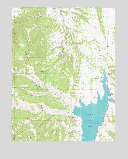
Scofield Reservoir, UT USGS Topographic Map
Click on map above to begin viewing in our Map Viewer.

This topographic map contains these locations and features:
Feature Name Type Latitude Longitude GNIS ID View Map
Anderson CanyonValleyN39.7739°W111.2030°1438210View Map
Anderson CreekStreamN39.7752°W111.2018°1451177View Map
Andrew Dairy CanyonValleyN39.7750°W111.1855°1438221View Map
Bear CanyonValleyN39.7827°W111.1757°1438442View Map
Bear SpringSpringN39.7957°W111.2352°1438492View Map
Big RidgeRidgeN39.7550°W111.2393°1438724View Map
Bishop SpringSpringN39.7938°W111.2497°1438820View Map
East Fork Dairy CanyonValleyN39.7647°W111.1949°1440800View Map
Eternal FlatFlatN39.7572°W111.2202°1440964View Map
Fish CreekStreamN39.7780°W111.1757°1441075View Map
Fish Creek CampgroundLocaleN39.7741°W111.2030°1441079View Map
French CreekStreamN39.7777°W111.2141°1441240View Map
Gooseberry CreekStreamN39.7813°W111.2452°1441374View Map
Kelly CanyonValleyN39.8388°W111.1893°1442295View Map
Little Bear CreekStreamN39.7950°W111.2021°1442660View Map
Lost CreekStreamN39.8177°W111.1388°1442961View Map
Miller CanyonValleyN39.7625°W111.1416°1443482View Map
Mud RidgeRidgeN39.7550°W111.2288°1443679View Map
Pleasant Valley PointCliffN39.8297°W111.1391°1444482View Map
Pondtown CreekStreamN39.7827°W111.1757°1444574View Map
Pondtown Mine (historical)MineN39.8002°W111.2149°1448865View Map
Rock SpringSpringN39.8409°W111.1547°1445093View Map
Scofield CampgroundLocaleN39.7902°W111.1304°1448980View Map
Scofield Lake SRA Recreation SiteLocaleN39.8088°W111.1460°1453018View Map
Scofield ReservoirReservoirN39.7738°W111.1521°1445381View Map
Scofield State ParkParkN39.7686°W111.1527°1455906View Map
Spring CanyonValleyN39.8502°W111.2460°1445988View Map
Starvation SpringSpringN39.8149°W111.2119°1446103View Map
The BackswitchLocaleN39.8350°W111.1788°1446411View Map
Tucker CanyonValleyN39.7589°W111.1702°1446753View Map
Water HollowValleyN39.8594°W111.2374°1447060View Map
Wife CanyonValleyN39.7741°W111.1966°1447331View Map
Wife CreekStreamN39.7752°W111.1974°1451378View Map

Note: Coordinates in the location and feature list above are referenced to NAD83 datum.


Copyright (C) 2008-2024 Ryan Niemi / Sunset Dynamics ... All Rights Reserved