TopoQuest Logo
Do you find TopoQuest useful?
Help keep TopoQuest running and adding new maps/features by donating!
Bitcoin:  19c7KJd3qBynnjoSw5npx9KScwjBe4ifkT
Litecoin:  LXs6TkuXGGXo1vDsWCkWVdjQX94eUKd6ui
Home View Maps Find Maps Find Places Resources & Links


Shellman, Georgia Topographic Map

USGS Map Title: Shellman, GA
USGS Map MRC: 31084G5
DRG (GeoTIFF) Download: o31084g5.tif


Neighboring USGS Topographic Map Quads:


  Benevolence, GA  
31084H6
 

  Parrott, GA  
31084H5
 

  Bottsford, GA  
31084H4
 

  Brooksville, GA  
31084G6
 

  Shellman, GA  
31084G5
 

  Dawson, GA  
31084G4
 

  Martins Crossroads, GA  
31084F6
 

  Doverel, GA  
31084F5
 

  Chickasawhatchee, GA  
31084F4


Map MRC Location:

N32°
W85°
N32°
W84°
H8 H7 H6 H5 H4 H3 H2 H1
G8 G7 G6 G5 G4 G3 G2 G1
F8 F7 F6 F5 F4 F3 F2 F1
E8 E7 E6 E5 E4 E3 E2 E1
D8 D7 D6 D5 D4 D3 D2 D1
C8 C7 C6 C5 C4 C3 C2 C1
B8 B7 B6 B5 B4 B3 B2 B1
A8 A7 A6 A5 A4 A3 A2 A1
N31°
W85°
N31°
W84°

Shellman, GA USGS 1:24K Topographic Map Preview:
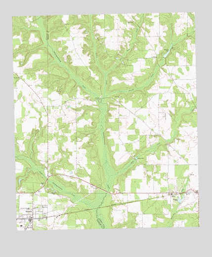
Shellman, GA USGS Topographic Map
Click on map above to begin viewing in our Map Viewer.

This topographic map contains these locations and features:
Feature Name Type Latitude Longitude GNIS ID View Map
Chenube CreekStreamN31.8235°W84.5655°355133View Map
City of ShellmanCivilN31.7571°W84.6159°2405457View Map
First Baptist ChurchChurchN31.7582°W84.6158°344736View Map
Gaines ChapelChurchN31.7699°W84.5027°314473View Map
GravesPopulated PlaceN31.7682°W84.5191°356082View Map
Graves Methodist ChurchChurchN31.7699°W84.5180°344654View Map
Ichawaynochaway MonumentParkN31.8260°W84.5663°344663View Map
Jones Mill (historical)LocaleN31.8488°W84.5208°344664View Map
Lay School (historical)SchoolN31.8018°W84.5827°344668View Map
Little Ichawaynochaway CreekStreamN31.7610°W84.5699°317095View Map
Macedonia ChurchChurchN31.8699°W84.5885°317534View Map
McGills PondReservoirN31.8532°W84.5184°317918View Map
McGills Pond DamDamN31.8496°W84.5210°338504View Map
Meltons Mill (historical)LocaleN31.7899°W84.5421°344671View Map
New Bethel CemeteryCemeteryN31.8043°W84.5282°344675View Map
New Bethel ChurchChurchN31.8043°W84.5277°319273View Map
New Hope ChurchChurchN31.8393°W84.6210°319381View Map
Oak Grove ChurchChurchN31.8013°W84.5827°319779View Map
Parrott DivisionCivilN31.8678°W84.5033°1936461View Map
Pierce ChapelChurchN31.8707°W84.5416°320493View Map
Pierces Chapel CemeteryCemeteryN31.8710°W84.5427°344685View Map
Pine Head CreekStreamN31.8396°W84.5613°320589View Map
Randolph Southern SchoolSchoolN31.7629°W84.6166°321310View Map
Rehobeth ChurchChurchN31.7766°W84.6069°321498View Map
Rehoboth Church CemeteryCemeteryN31.7764°W84.6078°2585223View Map
Rose Hill ChurchChurchN31.7699°W84.5085°321920View Map
Sand Hill CemeteryCemeteryN31.8449°W84.5469°322417View Map
Sand Hill ChurchChurchN31.8496°W84.5266°322425View Map
ShellmanPopulated PlaceN31.7563°W84.6152°356533View Map
Shellman Historic DistrictParkN31.7596°W84.6138°344770View Map
Shellman Police DepartmentBuildingN31.7579°W84.6163°2734192View Map
Shellman Volunteer Fire DepartmentBuildingN31.7563°W84.6157°2603845View Map
Shiloh CemeteryCemeteryN31.8268°W84.5524°344698View Map
Shiloh ChurchChurchN31.8263°W84.5527°322862View Map
Smiths PondLakeN31.7908°W84.5421°323162View Map
Stephans PondReservoirN31.7661°W84.5125°342233View Map
Stephens Pond DamDamN31.7643°W84.5138°342232View Map
Terrell AcademySchoolN31.7696°W84.5185°324010View Map
Turkey CreekStreamN31.8268°W84.5630°324377View Map
Wolf CreekStreamN31.7802°W84.5605°325489View Map

Note: Coordinates in the location and feature list above are referenced to NAD83 datum.


Copyright (C) 2008-2024 Ryan Niemi / Sunset Dynamics ... All Rights Reserved