TopoQuest Logo
Do you find TopoQuest useful?
Help keep TopoQuest running and adding new maps/features by donating!
Bitcoin:  19c7KJd3qBynnjoSw5npx9KScwjBe4ifkT
Litecoin:  LXs6TkuXGGXo1vDsWCkWVdjQX94eUKd6ui
Home View Maps Find Maps Find Places Resources & Links


Martins Crossroads, Georgia Topographic Map

USGS Map Title: Martins Crossroads, GA
USGS Map MRC: 31084F6
DRG (GeoTIFF) Download: o31084f6.tif


Neighboring USGS Topographic Map Quads:


  Cuthbert, GA  
31084G7
 

  Brooksville, GA  
31084G6
 

  Shellman, GA  
31084G5
 

  Carnegie, GA  
31084F7
 

  Martins Crossroads, GA  
31084F6
 

  Doverel, GA  
31084F5
 

  Bluffton, GA  
31084E7
 

  Edison, GA  
31084E6
 

  Morgan, GA  
31084E5


Map MRC Location:

N32°
W85°
N32°
W84°
H8 H7 H6 H5 H4 H3 H2 H1
G8 G7 G6 G5 G4 G3 G2 G1
F8 F7 F6 F5 F4 F3 F2 F1
E8 E7 E6 E5 E4 E3 E2 E1
D8 D7 D6 D5 D4 D3 D2 D1
C8 C7 C6 C5 C4 C3 C2 C1
B8 B7 B6 B5 B4 B3 B2 B1
A8 A7 A6 A5 A4 A3 A2 A1
N31°
W85°
N31°
W84°

Martins Crossroads, GA USGS 1:24K Topographic Map Preview:
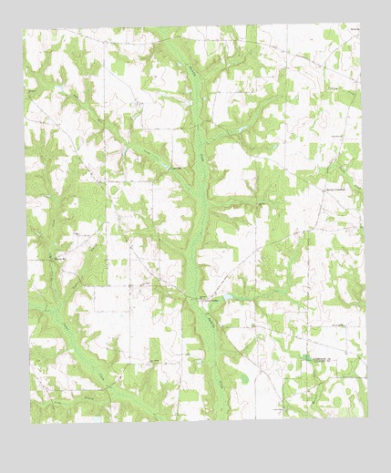
Martins Crossroads, GA USGS Topographic Map
Click on map above to begin viewing in our Map Viewer.

This topographic map contains these locations and features:
Feature Name Type Latitude Longitude GNIS ID View Map
Beulah Church (historical)ChurchN31.7196°W84.6805°344720View Map
Bridges LakeReservoirN31.6268°W84.7249°342080View Map
Bridges Lake DamDamN31.6268°W84.7249°342079View Map
Curry LakeReservoirN31.6652°W84.6962°342082View Map
Curry Lake DamDamN31.6668°W84.6966°342081View Map
Damascus Baptist Church CemeteryCemeteryN31.7297°W84.7491°2585284View Map
Damascus ChurchChurchN31.7302°W84.7488°355428View Map
Fountain BridgeBridgeN31.6635°W84.6849°314308View Map
Goffs MillPopulated PlaceN31.7054°W84.6958°331835View Map
Goffs Mill CreekStreamN31.6963°W84.6835°314667View Map
Grubbs Airport (historical)AirportN31.6560°W84.7166°344740View Map
Hopewell ChurchChurchN31.6632°W84.6855°315645View Map
Jacobs ChapelChurchN31.6282°W84.6558°316029View Map
Long BranchStreamN31.6341°W84.7169°317325View Map
Martins CrossroadsPopulated PlaceN31.6971°W84.6388°326387View Map
Mount Airy ChurchChurchN31.6932°W84.6635°318547View Map
Mount Calvary ChurchChurchN31.6543°W84.6327°318576View Map
New Bethel Baptist Church CemeteryCemeteryN31.6437°W84.7060°2585313View Map
New Bethel ChurchChurchN31.6443°W84.7052°319271View Map
Shellman DivisionCivilN31.7370°W84.6283°1936538View Map
Shivers MillPopulated PlaceN31.6768°W84.7399°333039View Map
Shivers Mill CreekStreamN31.6629°W84.7377°322920View Map
Taylor BranchStreamN31.6596°W84.7394°323940View Map
Union Hill ChurchChurchN31.7141°W84.6319°324566View Map
Vilulah ChurchChurchN31.6849°W84.7305°324712View Map
Williams LakeReservoirN31.6644°W84.6760°337470View Map
Williams Lake DamDamN31.6652°W84.6766°337469View Map
Zion Rock ChurchChurchN31.6688°W84.7071°325714View Map

Note: Coordinates in the location and feature list above are referenced to NAD83 datum.


Copyright (C) 2008-2024 Ryan Niemi / Sunset Dynamics ... All Rights Reserved