TopoQuest Logo
Do you find TopoQuest useful?
Help keep TopoQuest running and adding new maps/features by donating!
Bitcoin:  19c7KJd3qBynnjoSw5npx9KScwjBe4ifkT
Litecoin:  LXs6TkuXGGXo1vDsWCkWVdjQX94eUKd6ui
Home View Maps Find Maps Find Places Resources & Links


South Tent Mountain, Utah Topographic Map

USGS Map Title: South Tent Mountain, UT
USGS Map MRC: 39111D3
DRG (GeoTIFF) Download: o39111d3.tif


Neighboring USGS Topographic Map Quads:


  Mount Pleasant, UT  
39111E4
 

  Huntington Reservoir, UT  
39111E3
 

  Candland Mountain, UT  
39111E2
 

  Spring City, UT  
39111D4
 

  South Tent Mountain, UT  
39111D3
 

  Rilda Canyon, UT  
39111D2
 

  Danish Knoll, UT  
39111C4
 

  Joes Valley Reservoir, UT  
39111C3
 

  Mahogany Point, UT  
39111C2


Map MRC Location:

N40°
W112°
N40°
W111°
H8 H7 H6 H5 H4 H3 H2 H1
G8 G7 G6 G5 G4 G3 G2 G1
F8 F7 F6 F5 F4 F3 F2 F1
E8 E7 E6 E5 E4 E3 E2 E1
D8 D7 D6 D5 D4 D3 D2 D1
C8 C7 C6 C5 C4 C3 C2 C1
B8 B7 B6 B5 B4 B3 B2 B1
A8 A7 A6 A5 A4 A3 A2 A1
N39°
W112°
N39°
W111°

South Tent Mountain, UT USGS 1:24K Topographic Map Preview:
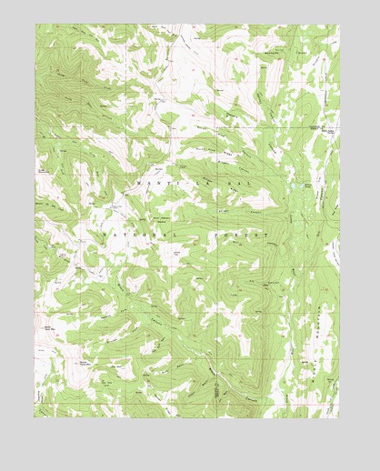
South Tent Mountain, UT USGS Topographic Map
Click on map above to begin viewing in our Map Viewer.

This topographic map contains these locations and features:
Feature Name Type Latitude Longitude GNIS ID View Map
Bacon Rind CanyonValleyN39.4525°W111.2791°1438321View Map
Bacon Rind RidgeRidgeN39.4594°W111.3010°1438322View Map
Becks CabinLocaleN39.3755°W111.3180°1438552View Map
Bennetts CanyonValleyN39.4944°W111.2557°1438600View Map
Black CanyonCanalN39.4380°W111.3366°1438829View Map
Black CanyonValleyN39.3772°W111.2735°1438832View Map
Booths CanyonValleyN39.4666°W111.2760°1439008View Map
Brough ForkStreamN39.4058°W111.3241°1439160View Map
Browns CanyonValleyN39.4494°W111.2727°1439171View Map
Buck BasinValleyN39.3952°W111.3077°1439215View Map
Bulger CanyonValleyN39.4380°W111.2713°1439259View Map
Bulger RidgeRidgeN39.4477°W111.2996°1439260View Map
Cedar Creek TunnelTunnelN39.4416°W111.3441°1439564View Map
Cow ForkStreamN39.4639°W111.3674°1440085View Map
Dry CanyonValleyN39.4161°W111.2685°1440566View Map
Elizas ForkStreamN39.4572°W111.3510°1440897View Map
Fly CanyonValleyN39.4136°W111.2710°1441151View Map
Hogan BasinValleyN39.3889°W111.3005°1441797View Map
Little Buck BasinValleyN39.4022°W111.3185°1442673View Map
Little MountainSummitN39.3905°W111.3405°1442746View Map
Lost BasinValleyN39.3841°W111.2946°1442955View Map
Lowry TopSummitN39.4272°W111.3199°1443034View Map
Manti National ForestForestN39.4010°W111.3299°1878748View Map
Meadow ForkStreamN39.4089°W111.3310°1443277View Map
Middle MountainSummitN39.4014°W111.2585°1443370View Map
Mill CanyonValleyN39.4233°W111.2705°1443406View Map
Mountain TunnelTunnelN39.4550°W111.3166°1443652View Map
Mountain Tunnel DitchCanalN39.4533°W111.3235°1443653View Map
North Tent MountainSummitN39.4033°W111.3718°1443982View Map
Potters CanyonValleyN39.4539°W111.2710°1444610View Map
Potters Canyon DitchCanalN39.4916°W111.3113°1444611View Map
Potters Pond Number One DamDamN39.4483°W111.2691°1447792View Map
Potters Pond Number Two DamDamN39.4483°W111.2674°1447791View Map
Potters PondsLakeN39.4486°W111.2667°1444612View Map
Red Pine CoveValleyN39.3816°W111.3416°1444822View Map
Scad Valley DivideGapN39.4664°W111.2516°1445368View Map
Sheep FlatFlatN39.4483°W111.2602°1445504View Map
Soren Peterson MeadowFlatN39.4377°W111.3238°1445784View Map
South Tent MountainSummitN39.3922°W111.3574°1445926View Map
Spring City DitchCanalN39.4261°W111.3410°1445994View Map
Spring City TunnelTunnelN39.4227°W111.3566°1445996View Map

Note: Coordinates in the location and feature list above are referenced to NAD83 datum.


Copyright (C) 2008-2025 Ryan Niemi / Sunset Dynamics ... All Rights Reserved