TopoQuest Logo
Do you find TopoQuest useful?
Help keep TopoQuest running and adding new maps/features by donating!
Bitcoin:  19c7KJd3qBynnjoSw5npx9KScwjBe4ifkT
Litecoin:  LXs6TkuXGGXo1vDsWCkWVdjQX94eUKd6ui
Home View Maps Find Maps Find Places Resources & Links


Sparta, Wisconsin Topographic Map

USGS Map Title: Sparta, WI
USGS Map MRC: 43090H7
DRG (GeoTIFF) Download: o43090h7.tif


Neighboring USGS Topographic Map Quads:


  Four Corners, WI  
44090A8
 

  Cataract, WI  
44090A7
 

  Alderwood Lake, WI  
44090A6
 

  Bangor, WI  
43090H8
 

  Sparta, WI  
43090H7
 

  City Rock, WI  
43090H6
 

  Middle Ridge, WI  
43090G8
 

  Melvina, WI  
43090G7
 

  Saint Marys, WI  
43090G6


Map MRC Location:

N44°
W91°
N44°
W90°
H8 H7 H6 H5 H4 H3 H2 H1
G8 G7 G6 G5 G4 G3 G2 G1
F8 F7 F6 F5 F4 F3 F2 F1
E8 E7 E6 E5 E4 E3 E2 E1
D8 D7 D6 D5 D4 D3 D2 D1
C8 C7 C6 C5 C4 C3 C2 C1
B8 B7 B6 B5 B4 B3 B2 B1
A8 A7 A6 A5 A4 A3 A2 A1
N43°
W91°
N43°
W90°

Sparta, WI USGS 1:24K Topographic Map Preview:
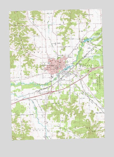
Sparta, WI USGS Topographic Map
Click on map above to begin viewing in our Map Viewer.

This topographic map contains these locations and features:
Feature Name Type Latitude Longitude GNIS ID View Map
AngeloPopulated PlaceN43.9708°W90.7779°1560868View Map
Angelo CemeteryCemeteryN43.9788°W90.7746°1560869View Map
Angelo H629.3 DamDamN43.9683°W90.7768°1793547View Map
Angelo PondReservoirN43.9702°W90.7702°1560872View Map
Balls BluffCliffN43.8808°W90.7676°1561135View Map
Beaver CreekStreamN43.9411°W90.8085°1561429View Map
Beaver Creek ParkParkN43.9452°W90.8107°1846180View Map
Blyton ParkParkN43.9502°W90.8087°1846184View Map
Bowler ValleyValleyN43.9968°W90.8210°1562102View Map
Calvary Baptist ChurchChurchN43.9497°W90.8190°1846190View Map
Castle RockPillarN43.9880°W90.8624°1562791View Map
City of SpartaCivilN43.9384°W90.8134°1584181View Map
East Beaver CreekStreamN43.9789°W90.8218°1564275View Map
East Beaver SchoolSchoolN43.9858°W90.8165°1564276View Map
Emergency Medical HeliportAirportN43.9375°W90.8282°1582214View Map
Evan Evans ParkParkN43.9411°W90.8090°1846204View Map
Exit 25CrossingN43.9205°W90.8212°1846207View Map
Farmers ValleyValleyN43.9341°W90.7907°1564862View Map
Farmers Valley CreekStreamN43.9411°W90.8051°1577339View Map
Fishermans ParkParkN43.9416°W90.8029°1846213View Map
Howard Huff ParkParkN43.9377°W90.8104°1846222View Map
Kingdom HallChurchN43.9697°W90.7582°1846228View Map
Lakeview Montessori SchoolSchoolN43.9467°W90.7998°1846233View Map
Lawrence - Lawson Elementary SchoolSchoolN43.9485°W90.8200°1846234View Map
LeonPopulated PlaceN43.8775°W90.8301°1567978View Map
Leon CemeteryCemeteryN43.8916°W90.8290°1846238View Map
Leon ValleyValleyN43.9150°W90.8499°1567979View Map
Little Creek SchoolSchoolN43.9364°W90.8493°1568235View Map
Lower Farmers Valley SchoolSchoolN43.9169°W90.7687°1568729View Map
Maplewood Elementary SchoolSchoolN43.9505°W90.7977°2582011View Map
Mayo Clinic Health System - Franciscan Healthcare in SpartaHospitalN43.9441°W90.8142°2698454View Map
Memorial ParkParkN43.9483°W90.7946°1846245View Map
Monroe County CourthouseBuildingN43.9439°W90.8157°1846248View Map
Monroe County JailBuildingN43.9441°W90.8132°2759837View Map
Monroe County Sheriff's DepartmentBuildingN43.9441°W90.8132°2759623View Map
Mount Hope CemeteryCemeteryN43.9436°W90.8315°1846250View Map
Paper Mill DamDamN43.9416°W90.8035°1792194View Map
Perch LakeReservoirN43.9435°W90.7982°1792195View Map
Putnam RidgeRidgeN43.9614°W90.8526°1571984View Map
Random SchoolSchoolN43.9136°W90.8446°1572070View Map
Reorganized Church of Jesus Christ of Latter Day SaintsChurchN43.9486°W90.8171°1846269View Map
Rolling Hills County HomeBuildingN43.9672°W90.8135°1846270View Map
Saint John's CemeteryCemeteryN43.9422°W90.8301°1846272View Map
Saint John's Evangelical Lutheran SchoolSchoolN43.9423°W90.8158°2715848View Map
Saint Johns Episcopal ChurchChurchN43.9480°W90.8112°1846273View Map
Saint Johns Evangelical Lutheran ChurchChurchN43.9425°W90.8162°1846274View Map
Saint Johns Lutheran ChurchChurchN43.9425°W90.8157°1846275View Map
Saint Marys HospitalHospitalN43.9447°W90.8140°1846279View Map
Saint Patrick's CemeteryCemeteryN43.9204°W90.8086°1574515View Map
Saint Patrick's SchoolSchoolN43.9440°W90.8155°1846284View Map
Saint Patricks Catholic ChurchChurchN43.9436°W90.8143°1846283View Map
Sand CreekStreamN43.8880°W90.8290°1573661View Map
Seventh Day Adventist ChurchChurchN43.9466°W90.8229°1846288View Map
Silver CreekStreamN43.9694°W90.7668°1574111View Map
Southside Elementary SchoolSchoolN43.9380°W90.7945°1846290View Map
SpartaPopulated PlaceN43.9441°W90.8129°1574514View Map
Sparta Area Ambulance ServiceBuildingN43.9383°W90.8185°2698326View Map
Sparta Area Christian SchoolSchoolN43.9486°W90.7977°2715736View Map
Sparta Area Independent Learning SchoolSchoolN43.9454°W90.8089°2582010View Map
Sparta Charter Prekindergarten SchoolSchoolN43.9454°W90.8089°2582007View Map
Sparta City Fire DepartmentBuildingN43.9436°W90.8099°2697821View Map
Sparta City HallBuildingN43.9430°W90.8126°1846291View Map
Sparta Free LibraryBuildingN43.9447°W90.8121°1846292View Map
Sparta High Point SchoolSchoolN43.9454°W90.8089°2582009View Map
Sparta High SchoolSchoolN43.9488°W90.8224°1846293View Map
Sparta Landing Field (historical)AirportN43.9608°W90.7726°1846294View Map
Sparta Meadowview Intermediate SchoolSchoolN43.9586°W90.8085°2715768View Map
Sparta Meadowview Middle SchoolSchoolN43.9586°W90.8085°2582006View Map
Sparta Mennonite SchoolSchoolN43.9388°W90.8018°2715734View Map
Sparta Middle SchoolSchoolN43.9452°W90.8090°1846295View Map
Sparta Police DepartmentBuildingN43.9432°W90.8098°2759653View Map
Sparta Post OfficePost OfficeN43.9441°W90.8121°1846296View Map
Sparta Rural Fire DepartmentBuildingN43.9436°W90.8091°2697690View Map
Sparta Wastewater Treatment PlantLocaleN43.9361°W90.8161°2709820View Map
Sparta-Gundersen ClinicHospitalN43.9433°W90.8149°1846297View Map
Town of SpartaCivilN43.9681°W90.8552°1584182View Map
Trinity Lutheran ChurchChurchN43.9505°W90.8112°1846312View Map
WCOW-AM (Sparta)TowerN43.9683°W90.8599°1582353View Map
WCOW-FM (Sparta)TowerN43.9683°W90.8599°1582461View Map
West Beaver CreekStreamN43.9786°W90.8221°1576450View Map
West Beaver SchoolSchoolN43.9722°W90.8251°1576451View Map
Westside ParkParkN43.9416°W90.8201°1846323View Map
Woodlawn CemeteryCemeteryN43.9536°W90.8092°1576998View Map

Note: Coordinates in the location and feature list above are referenced to NAD83 datum.


Copyright (C) 2008-2024 Ryan Niemi / Sunset Dynamics ... All Rights Reserved