TopoQuest Logo
Do you find TopoQuest useful?
Help keep TopoQuest running and adding new maps/features by donating!
Bitcoin:  19c7KJd3qBynnjoSw5npx9KScwjBe4ifkT
Litecoin:  LXs6TkuXGGXo1vDsWCkWVdjQX94eUKd6ui
Home View Maps Find Maps Find Places Resources & Links


City Rock, Wisconsin Topographic Map

USGS Map Title: City Rock, WI
USGS Map MRC: 43090H6
DRG (GeoTIFF) Download: o43090h6.tif


Neighboring USGS Topographic Map Quads:


  Cataract, WI  
44090A7
 

  Alderwood Lake, WI  
44090A6
 

  Tunnel City, WI  
44090A5
 

  Sparta, WI  
43090H7
 

  City Rock, WI  
43090H6
 

  Tomah, WI  
43090H5
 

  Melvina, WI  
43090G7
 

  Saint Marys, WI  
43090G6
 

  Wilton, WI  
43090G5


Map MRC Location:

N44°
W91°
N44°
W90°
H8 H7 H6 H5 H4 H3 H2 H1
G8 G7 G6 G5 G4 G3 G2 G1
F8 F7 F6 F5 F4 F3 F2 F1
E8 E7 E6 E5 E4 E3 E2 E1
D8 D7 D6 D5 D4 D3 D2 D1
C8 C7 C6 C5 C4 C3 C2 C1
B8 B7 B6 B5 B4 B3 B2 B1
A8 A7 A6 A5 A4 A3 A2 A1
N43°
W91°
N43°
W90°

City Rock, WI USGS 1:24K Topographic Map Preview:
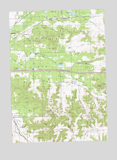
City Rock, WI USGS Topographic Map
Click on map above to begin viewing in our Map Viewer.

This topographic map contains these locations and features:
Feature Name Type Latitude Longitude GNIS ID View Map
Bailey CreekStreamN43.9925°W90.7376°1561087View Map
Bald BluffCliffN43.9614°W90.6310°1561118View Map
Big Sandy LakeLakeN43.9485°W90.6847°1846183View Map
Cave RockPillarN43.9041°W90.7010°1562825View Map
Chicken RockPillarN43.9016°W90.6915°1563012View Map
Chimney RockPillarN43.8791°W90.7101°1563025View Map
City RockPillarN43.8922°W90.7068°1563098View Map
Coles PeakSummitN43.9272°W90.6310°1563258View Map
Coles ValleyValleyN43.9403°W90.6793°1563260View Map
Coles Valley SchoolSchoolN43.9125°W90.6251°1563261View Map
County CemeteryCemeteryN43.9144°W90.6365°1846198View Map
East Silver LakeReservoirN43.9492°W90.6517°1574153View Map
Erdman HillSummitN43.8894°W90.6729°1846203View Map
Face RockPillarN43.9030°W90.6718°1564793View Map
Farmers ValleyPopulated PlaceN43.8991°W90.7479°1846208View Map
Farmers Valley CemeteryCemeteryN43.9036°W90.7498°1564863View Map
Fort McCoy Barrens State Natural AreaParkN43.9855°W90.6910°2059240View Map
Fort McCoy Fire Department South StationBuildingN43.9560°W90.7343°2697889View Map
Gates SchoolSchoolN43.8775°W90.6551°1565443View Map
Hickory Hill SchoolSchoolN43.8894°W90.7460°1566359View Map
Hill HSummitN43.9830°W90.6821°1566417View Map
Jeff Davis RockPillarN43.9061°W90.6446°1846225View Map
La Crosse River State Fishery AreaParkN43.9933°W90.7329°1846229View Map
Lafayette PassGapN43.9780°W90.6826°1567898View Map
Lower PassGapN43.9722°W90.7218°1568749View Map
Mound Prairie CemeteryCemeteryN43.9311°W90.6704°1846249View Map
Mound Prairie SchoolSchoolN43.9319°W90.6835°1569793View Map
Old Camp McCoyLocaleN43.9780°W90.7215°1570771View Map
Perry PeakSummitN43.9636°W90.6899°1571234View Map
Quarry HillSummitN43.9711°W90.7115°1571992View Map
Raymore PassGapN43.9758°W90.6490°1572116View Map
Sandy LakeLakeN43.9461°W90.7209°1846287View Map
School Number TwoSchoolN43.8989°W90.7151°1573806View Map
Scotts JunctionPopulated PlaceN43.9647°W90.6693°1577817View Map
Selfridge KnollSummitN43.9839°W90.7004°1573896View Map
Sparta/Fort Mc Coy AirportAirportN43.9562°W90.7332°1581049View Map
Stevens KnollSummitN43.9583°W90.6621°1574876View Map
Stillwell DamDamN43.9902°W90.6451°1574901View Map
Stillwell PondReservoirN43.9902°W90.6469°2770784View Map
Sugarbush HillSummitN43.8939°W90.6396°1846300View Map
Swamp PondReservoirN43.9614°W90.7217°2770785View Map
Thorp HillSummitN43.9691°W90.6726°1575405View Map
Town of AngeloCivilN43.9422°W90.7287°1582696View Map
Upper PassGapN43.9841°W90.6799°1575985View Map
Welch ChurchChurchN43.9314°W90.6687°1576410View Map
West Sandy LakeLakeN43.9460°W90.7392°1846321View Map
West Silver LakeReservoirN43.9543°W90.7246°1577189View Map
Young Tactical Landing SiteAirportN43.9539°W90.6645°1581984View Map

Note: Coordinates in the location and feature list above are referenced to NAD83 datum.


Copyright (C) 2008-2025 Ryan Niemi / Sunset Dynamics ... All Rights Reserved