TopoQuest Logo
Do you find TopoQuest useful?
Help keep TopoQuest running and adding new maps/features by donating!
Bitcoin:  19c7KJd3qBynnjoSw5npx9KScwjBe4ifkT
Litecoin:  LXs6TkuXGGXo1vDsWCkWVdjQX94eUKd6ui
Home View Maps Find Maps Find Places Resources & Links


Stacey, Montana Topographic Map

USGS Map Title: Stacey, MT
USGS Map MRC: 45105F8
DRG (GeoTIFF) Download: o45105f8.tif


Neighboring USGS Topographic Map Quads:


  Hayes Point, MT  
45106G1
 

  North Stacey School, MT  
45105G8
 

  Foster Creek School, MT  
45105G7
 

  Beaver Creek School, MT  
45106F1
 

  Stacey, MT  
45105F8
 

  Elk Ridge, MT  
45105F7
 

  Coleman Draw, MT  
45106E1
 

  Home Creek Butte, MT  
45105E8
 

  Samuelson Ranch, MT  
45105E7


Map MRC Location:

N46°
W106°
N46°
W105°
H8 H7 H6 H5 H4 H3 H2 H1
G8 G7 G6 G5 G4 G3 G2 G1
F8 F7 F6 F5 F4 F3 F2 F1
E8 E7 E6 E5 E4 E3 E2 E1
D8 D7 D6 D5 D4 D3 D2 D1
C8 C7 C6 C5 C4 C3 C2 C1
B8 B7 B6 B5 B4 B3 B2 B1
A8 A7 A6 A5 A4 A3 A2 A1
N45°
W106°
N45°
W105°

Stacey, MT USGS 1:24K Topographic Map Preview:
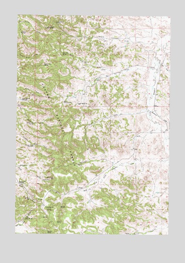
Stacey, MT USGS Topographic Map
Click on map above to begin viewing in our Map Viewer.

This topographic map contains these locations and features:
Feature Name Type Latitude Longitude GNIS ID View Map
01S46E36CDCD01 WellWellN45.6983°W105.9994°811220View Map
01S47E16CBCA01 WellWellN45.7358°W105.9514°811535View Map
01S47E20ACDA01 WellWellN45.7358°W105.9511°811534View Map
01S47E22DBAB01 WellWellN45.7344°W105.9106°811526View Map
01S47E23DDAD01 WellWellN45.7306°W105.8839°811489View Map
01S47E26CBBB01 WellWellN45.7203°W105.8933°811401View Map
01S47E27DBBD01 WellWellN45.7186°W105.9111°811382View Map
01S47E28ACCD01 WellWellN45.7203°W105.9336°811402View Map
01S47E34AACD01 WellWellN45.7089°W105.9064°811313View Map
02S47E04ADDB01 WellWellN45.6914°W105.9264°811173View Map
02S47E08ABBC01 WellWellN45.6817°W105.9514°811092View Map
02S47E10DADB01 WellWellN45.6736°W105.9047°811030View Map
02S47E19CDDB01 SpringSpringN45.6395°W105.9747°810733View Map
Beaver Creek WellWellN45.6983°W105.9997°779619View Map
Bidwell SpringSpringN45.6403°W105.9636°779751View Map
Bottom Crib SpringSpringN45.6880°W105.9864°780247View Map
Buckberry CreekStreamN45.6961°W105.8925°780521View Map
Coal CreekStreamN45.7217°W105.8847°781436View Map
East Fork SpringSpringN45.6336°W105.9922°782905View Map
Gaskill CreekStreamN45.7344°W105.8783°783855View Map
Gold CreekStreamN45.6892°W105.8856°784041View Map
Green CreekStreamN45.6969°W105.8936°784273View Map
Holiday CampgroundLocaleN45.6386°W105.9742°784938View Map
Horse Pasture ReservoirReservoirN45.7014°W105.9966°785056View Map
Liscom ButteSummitN45.7431°W105.9744°786214View Map
Liscom Butte SpringSpringN45.7456°W105.9692°786215View Map
North Stacey SpringSpringN45.7003°W105.9619°788305View Map
Oil Well ReservoirReservoirN45.6449°W105.9887°788397View Map
Road Creek ReservoirReservoirN45.6536°W105.9984°789618View Map
Sartin Draw SpringSpringN45.7217°W105.9782°776230View Map
Sheep Creek ReservoirReservoirN45.6564°W105.9698°790340View Map
South Stacey SpringSpringN45.6993°W105.9502°791114View Map
South Stacy SchoolSchoolN45.6988°W105.8889°791113View Map
Split Rock CreekStreamN45.7175°W105.9161°791166View Map
Split Rock SpringSpringN45.7273°W105.9634°791168View Map
Spring Number OneSpringN45.6556°W105.9784°791316View Map
Spring Number TwoSpringN45.6636°W105.9970°791318View Map
StaceyPopulated PlaceN45.7200°W105.8911°791402View Map
Stacey CreekStreamN45.7242°W105.8858°791403View Map
Straight Creek ReservoirReservoirN45.6754°W105.9865°791585View Map
Surprise SpringSpringN45.7398°W105.9974°791742View Map
Sutton SpringSpringN45.6316°W105.9664°791750View Map
Thomas SpringSpringN45.6259°W105.9741°792081View Map
Whitetail CreekStreamN45.6656°W105.9122°793238View Map
Whitetail Ranger StationLocaleN45.6403°W105.9761°793248View Map

Note: Coordinates in the location and feature list above are referenced to NAD83 datum.


Copyright (C) 2008-2025 Ryan Niemi / Sunset Dynamics ... All Rights Reserved