TopoQuest Logo
Do you find TopoQuest useful?
Help keep TopoQuest running and adding new maps/features by donating!
Bitcoin:  19c7KJd3qBynnjoSw5npx9KScwjBe4ifkT
Litecoin:  LXs6TkuXGGXo1vDsWCkWVdjQX94eUKd6ui
Home View Maps Find Maps Find Places Resources & Links


Blairstown, Missouri Topographic Map

USGS Map Title: Blairstown, MO
USGS Map MRC: 38093E8
DRG (GeoTIFF) Download: o38093e8.tif


Neighboring USGS Topographic Map Quads:


  Kingsville, MO  
38094F1
 

  Holden, MO  
38093F8
 

  Centerview, MO  
38093F7
 

  Quick City, MO  
38094E1
 

  Blairstown, MO  
38093E8
 

  Chilhowee, MO  
38093E7
 

  Creighton, MO  
38094D1
 

  Hartwell, MO  
38093D8
 

  Clinton North, MO  
38093D7


Map MRC Location:

N39°
W94°
N39°
W93°
H8 H7 H6 H5 H4 H3 H2 H1
G8 G7 G6 G5 G4 G3 G2 G1
F8 F7 F6 F5 F4 F3 F2 F1
E8 E7 E6 E5 E4 E3 E2 E1
D8 D7 D6 D5 D4 D3 D2 D1
C8 C7 C6 C5 C4 C3 C2 C1
B8 B7 B6 B5 B4 B3 B2 B1
A8 A7 A6 A5 A4 A3 A2 A1
N38°
W94°
N38°
W93°

Blairstown, MO USGS 1:24K Topographic Map Preview:
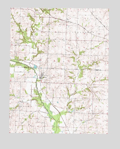
Blairstown, MO USGS Topographic Map
Click on map above to begin viewing in our Map Viewer.

This topographic map contains these locations and features:
Feature Name Type Latitude Longitude GNIS ID View Map
Bear CreekStreamN38.5650°W93.9727°713799View Map
Bear Creek ChurchChurchN38.6222°W93.9686°713813View Map
BlairstownPopulated PlaceN38.5558°W93.9608°755539View Map
Blairstown CemeteryCemeteryN38.5644°W93.9524°2702278View Map
Blairstown Post OfficePost OfficeN38.5555°W93.9603°2779459View Map
Blairstown School (historical)SchoolN38.5581°W93.9588°745489View Map
Blairstown School (historical)SchoolN38.5795°W93.9416°745534View Map
Blairstown Volunteer Fire DepartmentBuildingN38.5554°W93.9602°2621743View Map
Brushy Church (historical)ChurchN38.5371°W93.9872°745044View Map
Brushy CreekStreamN38.5331°W93.9602°714896View Map
Brushy School (historical)SchoolN38.5367°W93.9872°745452View Map
Carpenter CemeteryCemeteryN38.5705°W93.8927°715416View Map
City of BlairstownCivilN38.5579°W93.9578°2394187View Map
Compromise School (historical)SchoolN38.5500°W93.9233°745453View Map
DentonPopulated PlaceN38.6133°W93.9291°740808View Map
Denton School (historical)SchoolN38.6147°W93.9286°745542View Map
Eliza ann BranchStreamN38.5197°W93.9502°717445View Map
Farnsworth CemeteryCemeteryN38.5922°W93.9947°717856View Map
Landis (historical)LocaleN38.5281°W93.9458°740240View Map
NorrisPopulated PlaceN38.5206°W93.8955°729788View Map
Norris CreekStreamN38.5114°W93.9399°723427View Map
Norris School (historical)SchoolN38.5225°W93.8955°745483View Map
Old Channel Big CreekStreamN38.5650°W93.9730°723723View Map
Priestly CemeteryCemeteryN38.5899°W93.9936°724932View Map
Quick CemeteryCemeteryN38.5898°W93.9930°725022View Map
Star School (historical)SchoolN38.5877°W93.9888°2743985View Map
Township of Big CreekCivilN38.5130°W93.8999°766735View Map

Note: Coordinates in the location and feature list above are referenced to NAD83 datum.


Copyright (C) 2008-2025 Ryan Niemi / Sunset Dynamics ... All Rights Reserved