TopoQuest Logo
Do you find TopoQuest useful?
Help keep TopoQuest running and adding new maps/features by donating!
Bitcoin:  19c7KJd3qBynnjoSw5npx9KScwjBe4ifkT
Litecoin:  LXs6TkuXGGXo1vDsWCkWVdjQX94eUKd6ui
Home View Maps Find Maps Find Places Resources & Links


Herold, West Virginia Topographic Map

USGS Map Title: Herold, WV
USGS Map MRC: 38080E7
DRG (GeoTIFF) Download: o38080e7.tif


Neighboring USGS Topographic Map Quads:


  Rosedale, WV  
38080F8
 

  Gassaway, WV  
38080F7
 

  Sutton, WV  
38080F6
 

  Strange Creek, WV  
38080E8
 

  Herold, WV  
38080E7
 

  Little Birch, WV  
38080E6
 

  Swandale, WV  
38080D8
 

  Widen, WV  
38080D7
 

  Tioga, WV  
38080D6


Map MRC Location:

N39°
W81°
N39°
W80°
H8 H7 H6 H5 H4 H3 H2 H1
G8 G7 G6 G5 G4 G3 G2 G1
F8 F7 F6 F5 F4 F3 F2 F1
E8 E7 E6 E5 E4 E3 E2 E1
D8 D7 D6 D5 D4 D3 D2 D1
C8 C7 C6 C5 C4 C3 C2 C1
B8 B7 B6 B5 B4 B3 B2 B1
A8 A7 A6 A5 A4 A3 A2 A1
N38°
W81°
N38°
W80°

Herold, WV USGS 1:24K Topographic Map Preview:
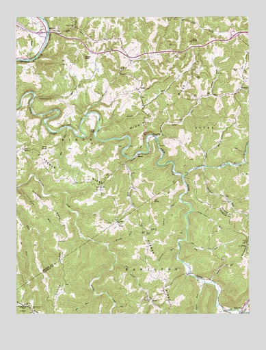
Herold, WV USGS Topographic Map
Click on map above to begin viewing in our Map Viewer.

This topographic map contains these locations and features:
Feature Name Type Latitude Longitude GNIS ID View Map
Barnette HillSummitN38.5307°W80.7512°1535272View Map
Baughman ChurchChurchN38.5354°W80.8032°1535313View Map
Big RunStreamN38.5307°W80.7848°1535904View Map
Big RunStreamN38.5787°W80.8476°1535907View Map
Big RunStreamN38.5079°W80.8329°1535940View Map
Blue HoleBayN38.5768°W80.8326°1536123View Map
Brushy ForkStreamN38.5293°W80.8273°1536497View Map
Buckeye ForkStreamN38.5915°W80.7707°1536587View Map
CanfieldPopulated PlaceN38.5943°W80.7540°1554060View Map
Canfield CemeteryCemeteryN38.6023°W80.7559°1537000View Map
Coalbed RunStreamN38.5487°W80.7876°1537477View Map
Coon KnobSummitN38.6148°W80.7807°1537634View Map
Cox Cemetery ChurchChurchN38.5284°W80.7512°1537757View Map
Davis KnobSummitN38.5695°W80.8615°1554265View Map
Diatter RunStreamN38.5832°W80.8373°1538171View Map
Dry ForkStreamN38.6207°W80.8443°1538351View Map
Elk River ChurchChurchN38.6073°W80.8668°1538633View Map
Eureka ChurchChurchN38.5693°W80.8707°1538750View Map
Feedtrough RunStreamN38.5434°W80.7807°1538913View Map
Fox KnobSummitN38.5473°W80.8012°1539206View Map
Frame RunStreamN38.5532°W80.8748°1539221View Map
HeroldPopulated PlaceN38.5673°W80.8098°1549736View Map
Interchange 51CrossingN38.6184°W80.8609°1727344View Map
Interchange 57CrossingN38.6170°W80.7579°1727345View Map
James KnobSummitN38.6079°W80.8384°1540814View Map
Keener RidgeRidgeN38.5432°W80.8223°1541102View Map
Kenton Meadows Senior BridgeBridgeN38.6185°W80.8580°2635299View Map
Leatherwood RunStreamN38.5915°W80.8654°1541596View Map
Little Birch RiverStreamN38.5576°W80.7851°1542031View Map
Long RunStreamN38.5745°W80.8004°1542415View Map
Lower Mill CreekStreamN38.5134°W80.7737°1542553View Map
Lower Mill CreekStreamN38.6068°W80.8676°1542554View Map
Meadville (historical)Populated PlaceN38.5451°W80.8584°1727361View Map
Middle RidgeRidgeN38.5879°W80.7904°1543208View Map
Middle RunPopulated PlaceN38.5940°W80.8098°1549822View Map
Middle RunStreamN38.5787°W80.8304°1543213View Map
Middle Run CemeteryCemeteryN38.5920°W80.8076°2586212View Map
Mill CreekStreamN38.5007°W80.7526°1543319View Map
MorrisPopulated PlaceN38.5059°W80.8026°1549832View Map
Mount Olive ChurchChurchN38.5537°W80.8307°1543707View Map
New Hope ChurchChurchN38.5059°W80.8032°1544123View Map
Polemic RunStreamN38.5618°W80.7734°1545113View Map
Polemic Run ChurchChurchN38.5473°W80.7601°1545114View Map
Powell CreekStreamN38.5004°W80.7537°1545217View Map
Road RunStreamN38.5623°W80.7737°1545823View Map
RocktonPopulated PlaceN38.6195°W80.8562°1555510View Map
Rose Hill School (historical)SchoolN38.5387°W80.8212°1546073View Map
Runnion RidgeRidgeN38.5329°W80.8457°1546152View Map
Slabcamp RunStreamN38.5282°W80.7876°1546895View Map
Southern DistrictCivilN38.6133°W80.8440°1928366View Map
Spring Bottom RunStreamN38.5018°W80.7637°1547161View Map
Spruce Grove ChurchChurchN38.6209°W80.8437°1547251View Map
Sutton RunStreamN38.5140°W80.7701°1547783View Map
Tinnel/Mollohan Family CemeteryCemeteryN38.5010°W80.7664°2586393View Map
Trace ForkStreamN38.5223°W80.8220°1548227View Map
Twistville (historical)Populated PlaceN38.6084°W80.8148°1727386View Map
WadePopulated PlaceN38.5379°W80.8207°1555900View Map
Walker CemeteryCemeteryN38.5340°W80.8057°1548717View Map
Walnut Grove CemeteryCemeteryN38.5026°W80.8665°1741372View Map
Walnut Grove United Methodist ChurchChurchN38.5023°W80.8668°1548762View Map
Wolf Pen RunStreamN38.5657°W80.8154°1549283View Map

Note: Coordinates in the location and feature list above are referenced to NAD83 datum.


Copyright (C) 2008-2024 Ryan Niemi / Sunset Dynamics ... All Rights Reserved