TopoQuest Logo
Do you find TopoQuest useful?
Help keep TopoQuest running and adding new maps/features by donating!
Bitcoin:  19c7KJd3qBynnjoSw5npx9KScwjBe4ifkT
Litecoin:  LXs6TkuXGGXo1vDsWCkWVdjQX94eUKd6ui
Home View Maps Find Maps Find Places Resources & Links


Tecumseh South, Michigan Topographic Map

USGS Map Title: Tecumseh South, MI
USGS Map MRC: 41083H8
DRG (GeoTIFF) Download: o41083h8.tif


Neighboring USGS Topographic Map Quads:


  Tipton, MI  
42084A1
 

  Tecumseh North, MI  
42083A8
 

  Macon, MI  
42083A7
 

  Adrian, MI  
41084H1
 

  Tecumseh South, MI  
41083H8
 

  Deerfield, MI  
41083H7
 

  Jasper, MI  
41084G1
 

  Palmyra, MI  
41083G8
 

  Blissfield, MI  
41083G7


Map MRC Location:

N42°
W84°
N42°
W83°
H8 H7 H6 H5 H4 H3 H2 H1
G8 G7 G6 G5 G4 G3 G2 G1
F8 F7 F6 F5 F4 F3 F2 F1
E8 E7 E6 E5 E4 E3 E2 E1
D8 D7 D6 D5 D4 D3 D2 D1
C8 C7 C6 C5 C4 C3 C2 C1
B8 B7 B6 B5 B4 B3 B2 B1
A8 A7 A6 A5 A4 A3 A2 A1
N41°
W84°
N41°
W83°

Tecumseh South, MI USGS 1:24K Topographic Map Preview:
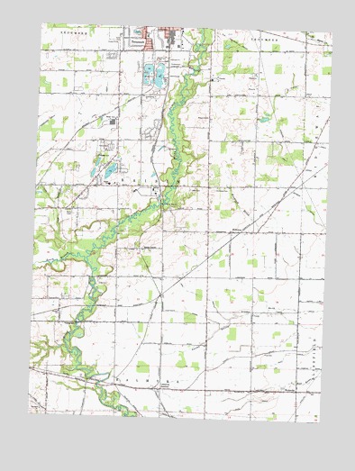
Tecumseh South, MI USGS Topographic Map
Click on map above to begin viewing in our Map Viewer.

This topographic map contains these locations and features:
Feature Name Type Latitude Longitude GNIS ID View Map
Ash DrainStreamN41.9073°W83.9155°620265View Map
Cal Zorn Recreation ComplexParkN41.9919°W83.9475°2438326View Map
Chase's StationLocaleN41.9289°W83.9539°2435552View Map
Clark Family CemeteryCemeteryN41.8889°W83.9639°2465685View Map
Cook DrainStreamN41.9267°W83.9844°623735View Map
Frye CemeteryCemeteryN41.8964°W83.9002°626543View Map
Hazelbank CemeteryCemeteryN41.9389°W83.9814°2465680View Map
Holdridge Family CemeteryCemeteryN41.9494°W83.9167°2465679View Map
HollowayPopulated PlaceN41.9350°W83.9144°628437View Map
Holloway CemeteryCemeteryN41.9489°W83.9222°628438View Map
Holloway Post Office (historical)Post OfficeN41.9350°W83.9144°2435682View Map
Holloway StationLocaleN41.9350°W83.9147°2435560View Map
Holy Family ClinicHospitalN41.9994°W83.9375°2436102View Map
Lenawee JunctionPopulated PlaceN41.8845°W83.9438°1617679View Map
Lenawee Junction Post Office (historical)Post OfficeN41.8844°W83.9439°2435677View Map
Lenawee Junction StationLocaleN41.8844°W83.9442°2435559View Map
Lenawee Seventh-Day Adventist SchoolSchoolN41.9889°W83.9653°2436100View Map
McLain CemeteryCemeteryN41.9714°W83.9272°631969View Map
Merillat AirportAirportN41.9666°W83.9234°1624176View Map
Mitchell ParkParkN41.9642°W83.9561°2438323View Map
Pope DrainStreamN41.8864°W83.8902°635238View Map
Raisin CenterPopulated PlaceN41.9289°W83.9533°1617809View Map
Raisin Center CemeteryCemeteryN41.9283°W83.9500°2465681View Map
Raisin Center ChurchChurchN41.9192°W83.9441°635611View Map
Raisin Center Post Office (historical)Post OfficeN41.9289°W83.9533°2435602View Map
Raisin Presbyterian ChurchChurchN41.9353°W83.9158°2465603View Map
Raisin Township Department of Public Safety PoliceBuildingN41.9686°W83.9647°2737638View Map
Raisin Township Fire DepartmentBuildingN41.9642°W83.9648°2436099View Map
Raisin Township Fire Department AnnexBuildingN41.9346°W83.9139°2620219View Map
Raisin Valley Golf CourseLocaleN41.9847°W83.9417°2436116View Map
South Branch River RaisinStreamN41.9242°W83.9769°638307View Map
Sulton Station (historical)LocaleN41.9494°W83.9472°2435549View Map
Sutton Elementary SchoolSchoolN41.9494°W83.9686°639134View Map
Sutton Post Office (historical)Post OfficeN41.9494°W83.9475°2435594View Map
Tecumseh Acres Elementary SchoolSchoolN41.9969°W83.9536°2436109View Map
Tecumseh Fire DepartmentBuildingN41.9928°W83.9441°2436104View Map
Tecumseh Free Will Baptist ChurchChurchN41.9761°W83.9653°2436095View Map
Tecumseh ParkParkN41.9986°W83.9586°2438327View Map
Tecumseh Seventh-Day Adventist ChurchChurchN41.9889°W83.9653°2436091View Map
Township of RaisinCivilN41.9486°W83.9452°1626950View Map
WellsvillePopulated PlaceN41.8845°W83.8855°1617927View Map
Wellsville United Methodist ChurchChurchN41.8858°W83.8853°2465652View Map
Westgate DrainStreamN41.9039°W83.9194°1616209View Map
WLEN-FM (Adrian)TowerN41.9031°W83.9869°1625332View Map

Note: Coordinates in the location and feature list above are referenced to NAD83 datum.


Copyright (C) 2008-2024 Ryan Niemi / Sunset Dynamics ... All Rights Reserved