TopoQuest Logo
Do you find TopoQuest useful?
Help keep TopoQuest running and adding new maps/features by donating!
Bitcoin:  19c7KJd3qBynnjoSw5npx9KScwjBe4ifkT
Litecoin:  LXs6TkuXGGXo1vDsWCkWVdjQX94eUKd6ui
Home View Maps Find Maps Find Places Resources & Links


Tidioute, Pennsylvania Topographic Map

USGS Map Title: Tidioute, PA
USGS Map MRC: 41079F4
DRG (GeoTIFF) Download: o41079f4.tif


Neighboring USGS Topographic Map Quads:


  Spring Creek, PA  
41079G5
 

  Pittsfield, PA  
41079G4
 

  Youngsville, PA  
41079G3
 

  Grand Valley, PA  
41079F5
 

  Tidioute, PA  
41079F4
 

  Cobham, PA  
41079F3
 

  Pleasantville, PA  
41079E5
 

  West Hickory, PA  
41079E4
 

  Kellettville, PA  
41079E3


Map MRC Location:

N42°
W80°
N42°
W79°
H8 H7 H6 H5 H4 H3 H2 H1
G8 G7 G6 G5 G4 G3 G2 G1
F8 F7 F6 F5 F4 F3 F2 F1
E8 E7 E6 E5 E4 E3 E2 E1
D8 D7 D6 D5 D4 D3 D2 D1
C8 C7 C6 C5 C4 C3 C2 C1
B8 B7 B6 B5 B4 B3 B2 B1
A8 A7 A6 A5 A4 A3 A2 A1
N41°
W80°
N41°
W79°

Tidioute, PA USGS 1:24K Topographic Map Preview:
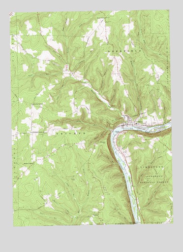
Tidioute, PA USGS Topographic Map
Click on map above to begin viewing in our Map Viewer.

This topographic map contains these locations and features:
Feature Name Type Latitude Longitude GNIS ID View Map
Babylon (historical)LocaleN41.6720°W79.4289°1210403View Map
Babylon HillSummitN41.6720°W79.4289°1209389View Map
Borough of TidiouteCivilN41.6848°W79.4003°1217398View Map
Cochener RunStreamN41.7006°W79.4325°1209518View Map
Courson EddyBayN41.6823°W79.3842°1209533View Map
Courson IslandIslandN41.6820°W79.3792°1210160View Map
Dale RunStreamN41.6473°W79.4067°1209543View Map
Dennis RunStreamN41.6806°W79.4248°1209556View Map
Dunn RunStreamN41.6331°W79.4031°1209576View Map
EagleLocaleN41.7417°W79.4914°1210405View Map
Economite HillLocaleN41.6759°W79.3948°1210411View Map
Excelsior CornerPopulated PlaceN41.6964°W79.4825°1209599View Map
FagundusPopulated PlaceN41.6326°W79.4331°1210173View Map
Fuellhart RunStreamN41.6959°W79.4239°1209620View Map
FunkvilleLocaleN41.6348°W79.4839°1210406View Map
George RunStreamN41.7145°W79.4548°1209626View Map
Gilmore RunStreamN41.7117°W79.4509°1209631View Map
Gordon RunStreamN41.6792°W79.4212°1209637View Map
Gorman CemeteryCemeteryN41.6520°W79.4508°1209638View Map
Gorman School (historical)SchoolN41.6426°W79.4645°1210314View Map
GrandinLocaleN41.6751°W79.4164°1210404View Map
Grove RunStreamN41.6603°W79.4164°1209647View Map
HemlockLocaleN41.7134°W79.4514°1212102View Map
Jones RunStreamN41.7198°W79.4548°1209713View Map
Lamb RunStreamN41.6353°W79.4467°1209743View Map
Lower EddyBayN41.6684°W79.4195°1209783View Map
Martin RunStreamN41.6289°W79.4514°1209800View Map
McGraw CornersLocaleN41.6614°W79.4834°1210193View Map
McGraw SchoolSchoolN41.6620°W79.4828°1210315View Map
McGuire IslandIslandN41.6812°W79.4028°1209804View Map
McGuire RunStreamN41.6823°W79.4053°1209805View Map
McGuire SchoolSchoolN41.7076°W79.3848°1210319View Map
Morrison CemeteryCemeteryN41.7423°W79.4254°1209832View Map
Morrison Hill SchoolSchoolN41.7142°W79.4112°1210318View Map
Myers RunStreamN41.6673°W79.4175°1209848View Map
Pedler RunStreamN41.7117°W79.4517°1209877View Map
Pleasant Grove School (historical)SchoolN41.6934°W79.4459°1210317View Map
Potter RunStreamN41.6834°W79.3795°1209905View Map
Rigrtona AirportAirportN41.6821°W79.4519°2442795View Map
Rock HollowValleyN41.7335°W79.4558°1209930View Map
Rock Hollow RunStreamN41.7328°W79.4559°1210376View Map
Russian HousesLocaleN41.6759°W79.3948°1210410View Map
Siggias IslandIslandN41.6501°W79.4081°1210417View Map
Sutton CornersLocaleN41.7459°W79.4248°1210024View Map
Sutton Hill SchoolSchoolN41.7459°W79.4245°1210320View Map
TidioutePopulated PlaceN41.6851°W79.4031°1217383View Map
Tidioute Area Volunteer Fire Department Station 71BuildingN41.6827°W79.4044°2644829View Map
Tidioute Borough Police DepartmentBuildingN41.6833°W79.4123°2776907View Map
Tidioute CreekStreamN41.6817°W79.4092°1210040View Map
Tidioute EddyBayN41.6809°W79.4073°1210041View Map
Tidioute Elementary SchoolSchoolN41.6839°W79.4020°1211636View Map
Tidioute High SchoolSchoolN41.6839°W79.4020°1211637View Map
Tidioute IslandIslandN41.6792°W79.4189°1210042View Map
Tidioute OverlookLocaleN41.6742°W79.3848°1210355View Map
Tidioute Post OfficePost OfficeN41.6833°W79.4108°2773002View Map
Township of DeerfieldCivilN41.7429°W79.3847°1217161View Map
Township of TriumphCivilN41.6749°W79.4577°1217179View Map
TriumphPopulated PlaceN41.6726°W79.4464°1210377View Map
Triumph SchoolSchoolN41.6809°W79.4462°1210316View Map
White SchoolSchoolN41.6298°W79.4373°1210313View Map
Whitehead CornersLocaleN41.6798°W79.4834°1210112View Map

Note: Coordinates in the location and feature list above are referenced to NAD83 datum.


Copyright (C) 2008-2025 Ryan Niemi / Sunset Dynamics ... All Rights Reserved