TopoQuest Logo
Do you find TopoQuest useful?
Help keep TopoQuest running and adding new maps/features by donating!
Bitcoin:  19c7KJd3qBynnjoSw5npx9KScwjBe4ifkT
Litecoin:  LXs6TkuXGGXo1vDsWCkWVdjQX94eUKd6ui
Home View Maps Find Maps Find Places Resources & Links


Youngsville, Pennsylvania Topographic Map

USGS Map Title: Youngsville, PA
USGS Map MRC: 41079G3
DRG (GeoTIFF) Download: o41079g3.tif


Neighboring USGS Topographic Map Quads:


  Lottsville, PA  
41079H4
 

  Sugar Grove, PA  
41079H3
 

  Russell, PA  
41079H2
 

  Pittsfield, PA  
41079G4
 

  Youngsville, PA  
41079G3
 

  Warren, PA  
41079G2
 

  Tidioute, PA  
41079F4
 

  Cobham, PA  
41079F3
 

  Cherry Grove, PA  
41079F2


Map MRC Location:

N42°
W80°
N42°
W79°
H8 H7 H6 H5 H4 H3 H2 H1
G8 G7 G6 G5 G4 G3 G2 G1
F8 F7 F6 F5 F4 F3 F2 F1
E8 E7 E6 E5 E4 E3 E2 E1
D8 D7 D6 D5 D4 D3 D2 D1
C8 C7 C6 C5 C4 C3 C2 C1
B8 B7 B6 B5 B4 B3 B2 B1
A8 A7 A6 A5 A4 A3 A2 A1
N41°
W80°
N41°
W79°

Youngsville, PA USGS 1:24K Topographic Map Preview:
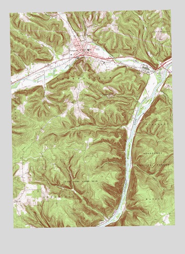
Youngsville, PA USGS Topographic Map
Click on map above to begin viewing in our Map Viewer.

This topographic map contains these locations and features:
Feature Name Type Latitude Longitude GNIS ID View Map
Allegheny Islands WildernessReserveN41.8197°W79.2714°2767360View Map
Allegheny SpringsPopulated PlaceN41.8267°W79.3039°1168173View Map
AlthomPopulated PlaceN41.7534°W79.3028°1168226View Map
Anders RunStreamN41.8356°W79.3184°1198032View Map
Borough of YoungsvilleCivilN41.8525°W79.3167°1215649View Map
Brokenstraw AirportAirportN41.8320°W79.3621°1194296View Map
Brokenstraw CreekStreamN41.8356°W79.2594°1192191View Map
Browns RunStreamN41.8739°W79.3350°1192197View Map
Browns RunStreamN41.8734°W79.3350°1210496View Map
Buckaloons Recreation AreaParkN41.8387°W79.2581°1170556View Map
Charley RunStreamN41.8037°W79.2798°1171584View Map
Clark RunStreamN41.7589°W79.2906°1171918View Map
Clark TrailTrailN41.7542°W79.2687°1171924View Map
Crippen HillSummitN41.8228°W79.3256°1172695View Map
Crulls IslandIslandN41.8203°W79.2714°1172787View Map
Davey Hill SchoolSchoolN41.7742°W79.3659°1201196View Map
Davy Hill ChurchChurchN41.7659°W79.3725°1172997View Map
Double RunStreamN41.7695°W79.3239°1173412View Map
Dry RunStreamN41.7598°W79.2939°1173540View Map
Dunn RunStreamN41.8056°W79.2814°1173621View Map
Hedgehog RunStreamN41.7842°W79.2837°1176760View Map
Hedgehog TrailTrailN41.7731°W79.2620°1176761View Map
Hull Hill SchoolSchoolN41.8745°W79.2967°1201200View Map
Indian Camp RunStreamN41.8562°W79.3153°1177737View Map
IrvinePopulated PlaceN41.8392°W79.2684°1177865View Map
Irvine Post OfficePost OfficeN41.8381°W79.2701°2773165View Map
Irvine RunStreamN41.8356°W79.2589°1177866View Map
Irvineton StationLocaleN41.8395°W79.2631°1201198View Map
Lenhart RunStreamN41.8284°W79.2620°1179196View Map
Lukens SchoolSchoolN41.7545°W79.2567°1201197View Map
Matthews RunStreamN41.8542°W79.3167°1192903View Map
McKinney RunStreamN41.8464°W79.2798°1180761View Map
Mead RunStreamN41.8437°W79.3306°1180812View Map
N E Forest Experimental StationLocaleN41.8387°W79.2614°1210437View Map
Pennsylvania HollowValleyN41.7844°W79.2872°1183538View Map
Saint Lukes ChurchChurchN41.8554°W79.3205°1186300View Map
Stone RidgeLocaleN41.7551°W79.2564°1208908View Map
Thompson RunStreamN41.7539°W79.3006°1189507View Map
Thompsons IslandIslandN41.7931°W79.2845°1189514View Map
Thompsons Station (historical)LocaleN41.7545°W79.3017°1206950View Map
Township of BrokenstrawCivilN41.8469°W79.3201°1217158View Map
Warren CountyCivilN41.8146°W79.2741°1213691View Map
Wilder FieldParkN41.8437°W79.2923°1210434View Map
Yankeebush SchoolSchoolN41.8656°W79.2567°1201199View Map
York MountainSummitN41.8288°W79.3251°1191900View Map
YoungsvillePopulated PlaceN41.8523°W79.3187°1191923View Map
Youngsville Borough Police DepartmentBuildingN41.8504°W79.3175°2777042View Map
Youngsville Elementary SchoolSchoolN41.8503°W79.3278°1211638View Map
Youngsville Post OfficePost OfficeN41.8504°W79.3170°2773056View Map
Youngsville Volunteer Fire DepartmentBuildingN41.8505°W79.3158°2644917View Map
Youngville High SchoolSchoolN41.8362°W79.3139°1206952View Map

Note: Coordinates in the location and feature list above are referenced to NAD83 datum.


Copyright (C) 2008-2025 Ryan Niemi / Sunset Dynamics ... All Rights Reserved