TopoQuest Logo
Do you find TopoQuest useful?
Help keep TopoQuest running and adding new maps/features by donating!
Bitcoin:  19c7KJd3qBynnjoSw5npx9KScwjBe4ifkT
Litecoin:  LXs6TkuXGGXo1vDsWCkWVdjQX94eUKd6ui
Home View Maps Find Maps Find Places Resources & Links


Kellettville, Pennsylvania Topographic Map

USGS Map Title: Kellettville, PA
USGS Map MRC: 41079E3
DRG (GeoTIFF) Download: o41079e3.tif


Neighboring USGS Topographic Map Quads:


  Tidioute, PA  
41079F4
 

  Cobham, PA  
41079F3
 

  Cherry Grove, PA  
41079F2
 

  West Hickory, PA  
41079E4
 

  Kellettville, PA  
41079E3
 

  Mayburg, PA  
41079E2
 

  Tionesta, PA  
41079D4
 

  Tylersburg, PA  
41079D3
 

  Marienville West, PA  
41079D2


Map MRC Location:

N42°
W80°
N42°
W79°
H8 H7 H6 H5 H4 H3 H2 H1
G8 G7 G6 G5 G4 G3 G2 G1
F8 F7 F6 F5 F4 F3 F2 F1
E8 E7 E6 E5 E4 E3 E2 E1
D8 D7 D6 D5 D4 D3 D2 D1
C8 C7 C6 C5 C4 C3 C2 C1
B8 B7 B6 B5 B4 B3 B2 B1
A8 A7 A6 A5 A4 A3 A2 A1
N41°
W80°
N41°
W79°

Kellettville, PA USGS 1:24K Topographic Map Preview:
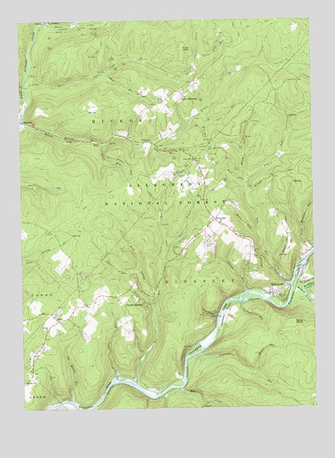
Kellettville, PA USGS Topographic Map
Click on map above to begin viewing in our Map Viewer.

This topographic map contains these locations and features:
Feature Name Type Latitude Longitude GNIS ID View Map
Bear CreekStreamN41.5067°W79.3070°1209402View Map
Beaver ValleyValleyN41.5915°W79.3740°1209409View Map
Beaver Valley School (historical)SchoolN41.5870°W79.3137°1210269View Map
Berlin ForkStreamN41.5559°W79.2784°1209418View Map
Camp RunStreamN41.5856°W79.3437°1209475View Map
Carpenter RunStreamN41.5340°W79.2850°1209482View Map
Church RunStreamN41.5376°W79.2825°1209500View Map
Crystal SpringsPopulated PlaceN41.5362°W79.3298°1209540View Map
Dice RunStreamN41.5451°W79.3248°1209560View Map
East Branch Ross RunStreamN41.5528°W79.3114°1209582View Map
East Fork Fork RunStreamN41.5742°W79.2809°1209585View Map
Fools KnobSummitN41.6159°W79.3092°1209606View Map
Fork RunStreamN41.5395°W79.2645°1209608View Map
Jakes RunStreamN41.5087°W79.3345°1209702View Map
Jug Handle RunStreamN41.5026°W79.3539°1209717View Map
KellettvillePopulated PlaceN41.5381°W79.2678°1209722View Map
Kiffer Hill ChurchChurchN41.5987°W79.3178°1209728View Map
Lamentation RunStreamN41.5176°W79.3000°1209744View Map
Lick RunStreamN41.5923°W79.2995°1209755View Map
Little Otter RunStreamN41.6134°W79.3020°1209771View Map
Middle Fork Fork RunStreamN41.5742°W79.2770°1209818View Map
Mount Zion ChurchChurchN41.5087°W79.3737°1209838View Map
NewtownLocaleN41.5306°W79.2873°1210270View Map
Newtown FlatsFlatN41.5303°W79.2925°1209854View Map
Reck BranchStreamN41.5365°W79.3167°1209918View Map
Reno RunStreamN41.6084°W79.3417°1209922View Map
Ross RunStreamN41.5076°W79.3267°1209943View Map
Ross Run JunctionLocaleN41.5090°W79.3264°1212046View Map
Salmon CreekStreamN41.5384°W79.2587°1210208View Map
StarrPopulated PlaceN41.5287°W79.3603°1210007View Map
Stony PointCliffN41.5276°W79.2642°1210018View Map
The BranchStreamN41.5381°W79.2539°1210033View Map
Toms RunStreamN41.5848°W79.3212°1210050View Map
Town HollowValleyN41.5294°W79.2916°1210052View Map
Town Line ChurchChurchN41.5798°W79.3042°1210053View Map
Township of HickoryCivilN41.5854°W79.3517°1216454View Map
Township of KingsleyCivilN41.5370°W79.2671°1216457View Map
West Fork Fork RunStreamN41.5723°W79.2775°1210099View Map
Whig HillPopulated PlaceN41.5609°W79.2962°1210106View Map
Whig Hill CemeteryCemeteryN41.5523°W79.2961°1210107View Map
White RunStreamN41.5120°W79.2820°1210111View Map
Wolf RunStreamN41.5937°W79.3039°1210133View Map
Yellow HammerPopulated PlaceN41.6001°W79.3095°1210144View Map
Zuendel ChurchChurchN41.5256°W79.3645°1210146View Map

Note: Coordinates in the location and feature list above are referenced to NAD83 datum.


Copyright (C) 2008-2024 Ryan Niemi / Sunset Dynamics ... All Rights Reserved