TopoQuest Logo
Do you find TopoQuest useful?
Help keep TopoQuest running and adding new maps/features by donating!
Bitcoin:  19c7KJd3qBynnjoSw5npx9KScwjBe4ifkT
Litecoin:  LXs6TkuXGGXo1vDsWCkWVdjQX94eUKd6ui
Home View Maps Find Maps Find Places Resources & Links


Cobham, Pennsylvania Topographic Map

USGS Map Title: Cobham, PA
USGS Map MRC: 41079F3
DRG (GeoTIFF) Download: o41079f3.tif


Neighboring USGS Topographic Map Quads:


  Pittsfield, PA  
41079G4
 

  Youngsville, PA  
41079G3
 

  Warren, PA  
41079G2
 

  Tidioute, PA  
41079F4
 

  Cobham, PA  
41079F3
 

  Cherry Grove, PA  
41079F2
 

  West Hickory, PA  
41079E4
 

  Kellettville, PA  
41079E3
 

  Mayburg, PA  
41079E2


Map MRC Location:

N42°
W80°
N42°
W79°
H8 H7 H6 H5 H4 H3 H2 H1
G8 G7 G6 G5 G4 G3 G2 G1
F8 F7 F6 F5 F4 F3 F2 F1
E8 E7 E6 E5 E4 E3 E2 E1
D8 D7 D6 D5 D4 D3 D2 D1
C8 C7 C6 C5 C4 C3 C2 C1
B8 B7 B6 B5 B4 B3 B2 B1
A8 A7 A6 A5 A4 A3 A2 A1
N41°
W80°
N41°
W79°

Cobham, PA USGS 1:24K Topographic Map Preview:
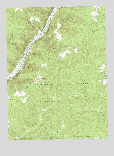
Cobham, PA USGS Topographic Map
Click on map above to begin viewing in our Map Viewer.

This topographic map contains these locations and features:
Feature Name Type Latitude Longitude GNIS ID View Map
Access PointCapeN41.6837°W79.3698°1209380View Map
Alex Magee RunStreamN41.7076°W79.3506°1209384View Map
Althom EddyBayN41.7437°W79.3173°1209387View Map
Baugher RunStreamN41.6839°W79.3695°1209399View Map
Beers HollowValleyN41.6281°W79.3317°1209411View Map
Big Buckhorn RunStreamN41.7164°W79.3731°1209420View Map
Bimber CornersLocaleN41.6826°W79.3356°1209426View Map
Bimber RunStreamN41.6828°W79.3689°1209427View Map
Bully HollowValleyN41.7236°W79.3268°1209457View Map
Camp RunStreamN41.6437°W79.3356°1209476View Map
Coalbed RunStreamN41.6478°W79.2581°1209515View Map
CobhamPopulated PlaceN41.7239°W79.3339°1209517View Map
Cobham SchoolSchoolN41.7242°W79.3159°1210325View Map
Conklin RunStreamN41.7401°W79.3209°1209522View Map
Connelly RunStreamN41.7228°W79.3345°1209523View Map
Coon RunStreamN41.6664°W79.2900°1209527View Map
Dark HollowValleyN41.6310°W79.3219°1209546View Map
Davy HillSummitN41.7328°W79.3384°1209550View Map
Dutchmans RunStreamN41.6798°W79.3606°1209580View Map
Economite CemeteryCemeteryN41.6714°W79.3636°1209588View Map
Fuellhart IslandIslandN41.6978°W79.3556°1209619View Map
GillisLocaleN41.7117°W79.2864°1210407View Map
Hague RunStreamN41.7153°W79.3456°1209653View Map
Harmonson CornersLocaleN41.7492°W79.2606°1212103View Map
Hearts Content Recreation SiteParkN41.6926°W79.2542°1210178View Map
Hickory Creek TrailTrailN41.6789°W79.2978°1210487View Map
Hickory Creek WildernessReserveN41.6756°W79.2938°2035153View Map
Izenbrown CornersLocaleN41.6639°W79.3725°1209695View Map
Jacks RunStreamN41.6662°W79.3189°1209696View Map
Jacks TrailTrailN41.6881°W79.2512°1209697View Map
Jaybuck RunStreamN41.6362°W79.3437°1209707View Map
Little RunStreamN41.7476°W79.3145°1209772View Map
Long Hollow Picnic AreaLocaleN41.6503°W79.3142°1209780View Map
MageePopulated PlaceN41.7017°W79.3562°1209788View Map
Magee EddyBayN41.7048°W79.3525°1209789View Map
Magee TrailTrailN41.7062°W79.3373°1209790View Map
McKean CornersLocaleN41.6689°W79.3592°1209806View Map
McKean SchoolSchoolN41.6695°W79.3587°1210323View Map
McKean School (historical)SchoolN41.7409°W79.3453°1210324View Map
Middle Hickory CreekStreamN41.6601°W79.3145°1209819View Map
Millstone IslandIslandN41.7109°W79.3487°1209825View Map
Perry Magee RunStreamN41.7048°W79.3525°1209881View Map
Piney RunStreamN41.6367°W79.3084°1209896View Map
Plank Road SchoolSchoolN41.7103°W79.2889°1209898View Map
QueenPopulated PlaceN41.6256°W79.3634°1209912View Map
Queen CreekStreamN41.6251°W79.3631°1210203View Map
Sandstone SpringsSpringN41.7259°W79.2639°1210354View Map
Sandstone Springs Picnic GroundLocaleN41.7273°W79.2620°1209955View Map
Shanley EddyBayN41.7170°W79.3400°1209969View Map
Slater RunStreamN41.7489°W79.3089°1209988View Map
Slater Run TrailTrailN41.7373°W79.2848°1209989View Map
Snow RunStreamN41.6923°W79.3617°1209995View Map
South Slater RunStreamN41.7403°W79.3025°1210003View Map
State Game Lands Number 29ParkN41.7314°W79.2562°1210216View Map
State Game Lands Number 86ParkN41.7253°W79.3581°1210010View Map
Station RunStreamN41.7273°W79.3292°1210012View Map
Stewards IslandIslandN41.7292°W79.3250°1210013View Map
Tanbark TrailTrailN41.7131°W79.2600°1210446View Map
Tidioute AirportAirportN41.6928°W79.3635°2443017View Map
Township of LimestoneCivilN41.6601°W79.3418°1217168View Map
Township of WatsonCivilN41.7111°W79.2547°1217180View Map
Waid RunStreamN41.6926°W79.3581°1210078View Map
Watson SchoolSchoolN41.6842°W79.2512°1210322View Map
Wheeler Fire TowerTowerN41.6909°W79.2573°1210321View Map

Note: Coordinates in the location and feature list above are referenced to NAD83 datum.


Copyright (C) 2008-2025 Ryan Niemi / Sunset Dynamics ... All Rights Reserved