TopoQuest Logo
Do you find TopoQuest useful?
Help keep TopoQuest running and adding new maps/features by donating!
Bitcoin:  19c7KJd3qBynnjoSw5npx9KScwjBe4ifkT
Litecoin:  LXs6TkuXGGXo1vDsWCkWVdjQX94eUKd6ui
Home View Maps Find Maps Find Places Resources & Links


Bluffton, Georgia Topographic Map

USGS Map Title: Bluffton, GA
USGS Map MRC: 31084E7
DRG (GeoTIFF) Download: o31084e7.tif


Neighboring USGS Topographic Map Quads:


  Coleman, GA  
31084F8
 

  Carnegie, GA  
31084F7
 

  Martins Crossroads, GA  
31084F6
 

  Zetto, GA  
31084E8
 

  Bluffton, GA  
31084E7
 

  Edison, GA  
31084E6
 

  Blakely North, GA  
31084D8
 

  Bancroft, GA  
31084D7
 

  Arlington, GA  
31084D6


Map MRC Location:

N32°
W85°
N32°
W84°
H8 H7 H6 H5 H4 H3 H2 H1
G8 G7 G6 G5 G4 G3 G2 G1
F8 F7 F6 F5 F4 F3 F2 F1
E8 E7 E6 E5 E4 E3 E2 E1
D8 D7 D6 D5 D4 D3 D2 D1
C8 C7 C6 C5 C4 C3 C2 C1
B8 B7 B6 B5 B4 B3 B2 B1
A8 A7 A6 A5 A4 A3 A2 A1
N31°
W85°
N31°
W84°

Bluffton, GA USGS 1:24K Topographic Map Preview:
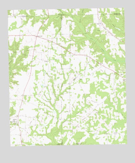
Bluffton, GA USGS Topographic Map
Click on map above to begin viewing in our Map Viewer.

This topographic map contains these locations and features:
Feature Name Type Latitude Longitude GNIS ID View Map
Blackburns Store (historical)Populated PlaceN31.6193°W84.8644°344722View Map
BlufftonPopulated PlaceN31.5229°W84.8677°311579View Map
Bluffton Baptist ChurchChurchN31.5207°W84.8680°344800View Map
Bluffton CemeteryCemeteryN31.5257°W84.8733°344801View Map
Bluffton High School (historical)SchoolN31.5202°W84.8680°344802View Map
Bluffton Methodist ChurchChurchN31.5199°W84.8680°344803View Map
Clay County Volunteer Fire Department Station 3BuildingN31.5266°W84.8659°2604321View Map
County School Number 2SchoolN31.5232°W84.8674°344219View Map
Darveys ChapelChurchN31.5607°W84.7991°313319View Map
Enon ChurchChurchN31.6135°W84.8360°313963View Map
Enterprise CemeteryCemeteryN31.5774°W84.8330°344810View Map
Enterprise ChurchChurchN31.5774°W84.8330°355706View Map
Faines LakeReservoirN31.5556°W84.8391°341970View Map
Faines Lake DamDamN31.5535°W84.8383°341969View Map
Fellows BranchStreamN31.6218°W84.8146°314094View Map
Friendship ChurchChurchN31.5218°W84.8724°314396View Map
Hattaway LakeReservoirN31.5585°W84.8716°340843View Map
Hattaway Lake DamDamN31.5585°W84.8716°340842View Map
JeffPopulated PlaceN31.5563°W84.8099°326341View Map
Jonesville School (historical)SchoolN31.5649°W84.7952°335065View Map
Mars Hill CemeteryCemeteryN31.5732°W84.7763°335070View Map
Mars Hill ChurchChurchN31.5735°W84.7769°317714View Map
McKinnon BranchStreamN31.6102°W84.7971°317946View Map
Mclendon AirportAirportN31.5875°W84.7907°2442673View Map
Mills CemeteryCemeteryN31.5399°W84.7880°335071View Map
Mount Ebel ChurchChurchN31.6046°W84.7766°318627View Map
MoyePopulated PlaceN31.6110°W84.7769°326410View Map
OaklandPopulated PlaceN31.5874°W84.8477°344830View Map
Oakland School (historical)SchoolN31.5888°W84.8471°344831View Map
ParksvillePopulated PlaceN31.5096°W84.7635°326453View Map
Parksville ChurchChurchN31.5099°W84.7713°320243View Map
Pleasant Grove CemeteryCemeteryN31.5404°W84.7891°335082View Map
Pleasant Grove ChurchChurchN31.5293°W84.7821°320804View Map
Suttons CornerPopulated PlaceN31.6007°W84.8441°326538View Map
Town of BlufftonCivilN31.5198°W84.8691°2405289View Map
Union ChurchChurchN31.5468°W84.8602°324512View Map
Vilulah CemeteryCemeteryN31.6204°W84.8694°344777View Map
Vilulah ChurchChurchN31.6199°W84.8685°324711View Map
Vincent CemeteryCemeteryN31.5241°W84.8199°344838View Map
Vincent ChurchChurchN31.5243°W84.8199°324713View Map
Williams CreekStreamN31.5074°W84.8305°325347View Map

Note: Coordinates in the location and feature list above are referenced to NAD83 datum.


Copyright (C) 2008-2024 Ryan Niemi / Sunset Dynamics ... All Rights Reserved