TopoQuest Logo
Do you find TopoQuest useful?
Help keep TopoQuest running and adding new maps/features by donating!
Bitcoin:  19c7KJd3qBynnjoSw5npx9KScwjBe4ifkT
Litecoin:  LXs6TkuXGGXo1vDsWCkWVdjQX94eUKd6ui
Home View Maps Find Maps Find Places Resources & Links


Sandy Ridge, Pennsylvania Topographic Map

USGS Map Title: Sandy Ridge, PA
USGS Map MRC: 40078G2
DRG (GeoTIFF) Download: o40078g2.tif


Neighboring USGS Topographic Map Quads:


  Wallaceton, PA  
40078H3
 

  Philipsburg, PA  
40078H2
 

  Black Moshannon, PA  
40078H1
 

  Houtzdale, PA  
40078G3
 

  Sandy Ridge, PA  
40078G2
 

  Port Matilda, PA  
40078G1
 

  Tipton, PA  
40078F3
 

  Tyrone, PA  
40078F2
 

  Franklinville, PA  
40078F1


Map MRC Location:

N41°
W79°
N41°
W78°
H8 H7 H6 H5 H4 H3 H2 H1
G8 G7 G6 G5 G4 G3 G2 G1
F8 F7 F6 F5 F4 F3 F2 F1
E8 E7 E6 E5 E4 E3 E2 E1
D8 D7 D6 D5 D4 D3 D2 D1
C8 C7 C6 C5 C4 C3 C2 C1
B8 B7 B6 B5 B4 B3 B2 B1
A8 A7 A6 A5 A4 A3 A2 A1
N40°
W79°
N40°
W78°

Sandy Ridge, PA USGS 1:24K Topographic Map Preview:
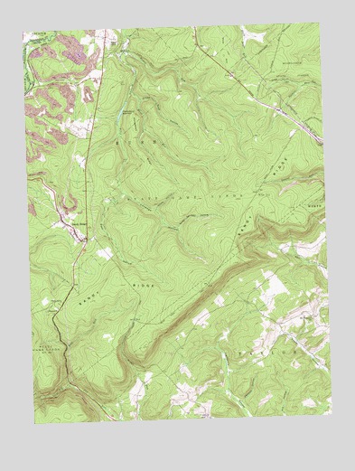
Sandy Ridge, PA USGS Topographic Map
Click on map above to begin viewing in our Map Viewer.

This topographic map contains these locations and features:
Feature Name Type Latitude Longitude GNIS ID View Map
Cabbage HollowValleyN40.8225°W78.2098°1170852View Map
Cabbage Hollow RunStreamN40.8228°W78.2100°1202609View Map
Crowns Nest HollowValleyN40.8525°W78.2010°1172778View Map
Deepcut HollowValleyN40.7556°W78.1617°1173077View Map
Glass CityPopulated PlaceN40.8714°W78.2150°1175675View Map
Hawk RunStreamN40.8551°W78.2050°1176667View Map
Henderson SchoolSchoolN40.7814°W78.1486°1201255View Map
Horse HollowValleyN40.8176°W78.1955°1177440View Map
Horseback RidgeRidgeN40.8403°W78.2039°1177455View Map
Mapleton JunctionLocaleN40.8581°W78.2456°1212917View Map
Mapleton Junction StationLocaleN40.8684°W78.2431°1212914View Map
Mount Pleasant ChurchChurchN40.7809°W78.1311°1181818View Map
Mount Vernon SchoolSchoolN40.7551°W78.2067°1201256View Map
Mountain Top Fire Company 13BuildingN40.8129°W78.2320°2645671View Map
Philipsburg ReservoirReservoirN40.8473°W78.2099°1183665View Map
Pine HillSummitN40.8659°W78.1650°1183826View Map
Pool HollowValleyN40.8183°W78.2171°1184244View Map
PoweltonLocaleN40.8151°W78.2364°1213058View Map
RetortLocaleN40.8134°W78.2353°1212918View Map
Rushton StationLocaleN40.8626°W78.2481°1212913View Map
Sandy RidgePopulated PlaceN40.8148°W78.2356°1186955View Map
Sandy RidgeRidgeN40.7926°W78.1758°1186958View Map
Sandy Ridge Census Designated PlaceCensusN40.8105°W78.2343°2390255View Map
Sandy Ridge Post OfficePost OfficeN40.8126°W78.2321°2772897View Map
Seven Springs HollowValleyN40.8114°W78.1869°1187264View Map
Shimel RunStreamN40.8712°W78.2481°1187521View Map
Slide Hollow TrailTrailN40.8651°W78.1347°1206393View Map
State Game Lands Number 33ParkN40.8209°W78.1750°1193450View Map
SummitLocaleN40.7878°W78.2408°1189034View Map
Tomtit RunStreamN40.8676°W78.2067°1189654View Map
Township of RushCivilN40.8615°W78.1666°1216136View Map
Township of TaylorCivilN40.7689°W78.1578°1216139View Map
Upper DamDamN40.8501°W78.2081°1195111View Map
Wolf RunStreamN40.7623°W78.2342°1191672View Map

Note: Coordinates in the location and feature list above are referenced to NAD83 datum.


Copyright (C) 2008-2025 Ryan Niemi / Sunset Dynamics ... All Rights Reserved