TopoQuest Logo
Do you find TopoQuest useful?
Help keep TopoQuest running and adding new maps/features by donating!
Bitcoin:  19c7KJd3qBynnjoSw5npx9KScwjBe4ifkT
Litecoin:  LXs6TkuXGGXo1vDsWCkWVdjQX94eUKd6ui
Home View Maps Find Maps Find Places Resources & Links


Dalton, Minnesota Topographic Map

USGS Map Title: Dalton, MN
USGS Map MRC: 46095B8
DRG (GeoTIFF) Download: o46095b8.tif


Neighboring USGS Topographic Map Quads:


  Fergus Falls, MN  
46096C1
 

  Wall Lake, MN  
46095C8
 

  Underwood, MN  
46095C7
 

  Dayton Hollow Dam, MN  
46096B1
 

  Dalton, MN  
46095B8
 

  Stalker Lake, MN  
46095B7
 

  Wendell, MN  
46096A1
 

  Fourmile Lake, MN  
46095A8
 

  Ashby, MN  
46095A7


Map MRC Location:

N47°
W96°
N47°
W95°
H8 H7 H6 H5 H4 H3 H2 H1
G8 G7 G6 G5 G4 G3 G2 G1
F8 F7 F6 F5 F4 F3 F2 F1
E8 E7 E6 E5 E4 E3 E2 E1
D8 D7 D6 D5 D4 D3 D2 D1
C8 C7 C6 C5 C4 C3 C2 C1
B8 B7 B6 B5 B4 B3 B2 B1
A8 A7 A6 A5 A4 A3 A2 A1
N46°
W96°
N46°
W95°

Dalton, MN USGS 1:24K Topographic Map Preview:
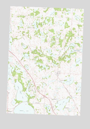
Dalton, MN USGS Topographic Map
Click on map above to begin viewing in our Map Viewer.

This topographic map contains these locations and features:
Feature Name Type Latitude Longitude GNIS ID View Map
Bahle LakeLakeN46.2298°W95.9810°639573View Map
Bromseth LakeLakeN46.2038°W95.9742°640500View Map
Calvary Free Lutheran ChurchChurchN46.1375°W95.9944°2071029View Map
City of DaltonCivilN46.1739°W95.9155°2393709View Map
Clear LakeLakeN46.1381°W95.9074°641290View Map
DaltonPopulated PlaceN46.1738°W95.9156°642612View Map
Dalton (historical)LocaleN46.1725°W95.9167°2073109View Map
Dalton City HallBuildingN46.1739°W95.9153°2073107View Map
Dalton Fire DepartmentBuildingN46.1737°W95.9174°2666679View Map
Dalton Free Lutheran ChurchChurchN46.1739°W95.9153°2073106View Map
Dalton Post Office (historical)Post OfficeN46.1739°W95.9153°2073104View Map
Dalton Trailer CourtPopulated PlaceN46.1739°W95.9153°2073108View Map
Formo LakeLakeN46.1650°W95.8963°643819View Map
Fossan LakeLakeN46.1989°W95.9308°643831View Map
Hansel LakeLakeN46.1322°W95.9298°644635View Map
Hansel Lake Rest AreaLocaleN46.1328°W95.9219°2073153View Map
Indian LakeLakeN46.2281°W95.9567°645413View Map
Interchange 67CrossingN46.1461°W95.9361°2073154View Map
Jotan LakeLakeN46.2073°W95.8924°645747View Map
KJJK-AM (Fergus Falls)TowerN46.2452°W95.9798°662916View Map
KJJK-FM (Fergus Falls)TowerN46.2452°W95.9798°663047View Map
Larson LakeLakeN46.2197°W95.9451°646503View Map
Long LakeLakeN46.1987°W95.8940°647079View Map
Mud LakeLakeN46.1794°W95.9680°648282View Map
North Tenmile LakeLakeN46.1501°W95.9762°648702View Map
Our Saviour's Lutheran ChurchChurchN46.1739°W95.9153°2073105View Map
Parkdale Post Office (historical)Post OfficeN46.1875°W95.9694°2072990View Map
Rose LakeLakeN46.1926°W95.9707°650267View Map
Rose LakeReservoirN46.1883°W95.9737°1776947View Map
Rose Lake DamDamN46.1883°W95.9737°1776946View Map
Rosvold LakeLakeN46.2438°W95.9289°650314View Map
Sarpsborg CemeteryCemeteryN46.1864°W95.9722°2071822View Map
Sarpsborg ChurchChurchN46.1863°W95.9728°651224View Map
School Number 126 (historical)SchoolN46.1878°W95.9733°2112821View Map
School Number 139 (historical)SchoolN46.1306°W95.9883°2112822View Map
School Number 19 (historical)SchoolN46.2094°W95.9322°2112816View Map
School Number 7 (historical)SchoolN46.1325°W95.9367°2112823View Map
School Number 81 (historical)SchoolN46.2119°W95.9792°2112815View Map
Sommer LakeLakeN46.1886°W95.8815°652253View Map
Steamboats on the Red River Historical MarkerParkN46.1328°W95.9219°2073152View Map
Swan Lake CemeteryCemeteryN46.2389°W95.9733°2072711View Map
Swan Lake ChurchChurchN46.2394°W95.9734°652906View Map
Swan Lake Lutheran Church Cemetery (historical)CemeteryN46.2181°W95.9661°2072709View Map
Swan Lake Resort and CampgroundLocaleN46.2167°W95.9989°2071059View Map
Ten Mile Lake CemeteryCemeteryN46.1442°W95.9392°2071821View Map
Tenmile LakeLakeN46.1258°W95.9666°653083View Map
Tenmile Lake ChurchChurchN46.1441°W95.9401°653085View Map
Tordenskjold ChurchChurchN46.2472°W95.8751°653241View Map
Tordenskjold Post Office (historical)Post OfficeN46.2236°W95.8792°2072971View Map
Township of Dane PrairieCivilN46.2388°W95.9571°663919View Map
Township of TumuliCivilN46.1517°W95.9571°665815View Map
Vinge LakeLakeN46.1577°W95.8782°653667View Map
Volen LakeLakeN46.2400°W95.8864°653682View Map
Zion Lutheran Church CemeteryCemeteryN46.1742°W95.9250°2071820View Map
Zion-Sarpsborg Free Lutheran ChurchChurchN46.1739°W95.9153°2073103View Map

Note: Coordinates in the location and feature list above are referenced to NAD83 datum.


Copyright (C) 2008-2025 Ryan Niemi / Sunset Dynamics ... All Rights Reserved