TopoQuest Logo
Do you find TopoQuest useful?
Help keep TopoQuest running and adding new maps/features by donating!
Bitcoin:  19c7KJd3qBynnjoSw5npx9KScwjBe4ifkT
Litecoin:  LXs6TkuXGGXo1vDsWCkWVdjQX94eUKd6ui
Home View Maps Find Maps Find Places Resources & Links


Urne, Wisconsin Topographic Map

USGS Map Title: Urne, WI
USGS Map MRC: 44091D8
DRG (GeoTIFF) Download: o44091d8.tif


Neighboring USGS Topographic Map Quads:


  Ella, WI  
44092E1
 

  Durand South, WI  
44091E8
 

  Tarrant, WI  
44091E7
 

  Wabasha North, MN  
44092D1
 

  Urne, WI  
44091D8
 

  Modena, WI  
44091D7
 

  Wabasha South, MN  
44092C1
 

  Alma, WI  
44091C8
 

  Cream, WI  
44091C7


Map MRC Location:

N45°
W92°
N45°
W91°
H8 H7 H6 H5 H4 H3 H2 H1
G8 G7 G6 G5 G4 G3 G2 G1
F8 F7 F6 F5 F4 F3 F2 F1
E8 E7 E6 E5 E4 E3 E2 E1
D8 D7 D6 D5 D4 D3 D2 D1
C8 C7 C6 C5 C4 C3 C2 C1
B8 B7 B6 B5 B4 B3 B2 B1
A8 A7 A6 A5 A4 A3 A2 A1
N44°
W92°
N44°
W91°

Urne, WI USGS 1:24K Topographic Map Preview:
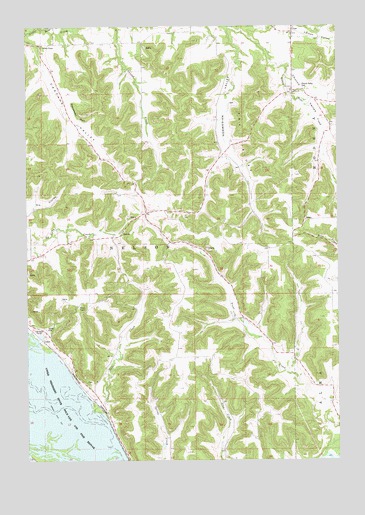
Urne, WI USGS Topographic Map
Click on map above to begin viewing in our Map Viewer.

This topographic map contains these locations and features:
Feature Name Type Latitude Longitude GNIS ID View Map
1.8 ReservoirReservoirN44.3766°W91.9452°1792331View Map
Big LakeLakeN44.3834°W91.9813°2729917View Map
Cascade ChapelChurchN44.4950°W91.9932°1562758View Map
Cascade CreekStreamN44.4984°W91.9994°2760539View Map
Cascade School (historical)SchoolN44.4947°W91.9935°1578540View Map
Cascade ValleyValleyN44.4979°W91.9998°1562761View Map
Catfish SloughGutN44.3776°W91.9922°2761285View Map
Church ValleyValleyN44.4886°W91.8981°1563083View Map
Church Valley CemeteryCemeteryN44.4822°W91.8879°1563084View Map
Deer CreekStreamN44.3891°W91.9743°1563817View Map
Deer Creek School (historical)SchoolN44.3952°W91.9741°1578541View Map
Fox BluffCliffN44.4683°W91.9129°1565203View Map
Klopp FarmLocaleN44.4731°W91.8825°2645941View Map
Larson ValleyValleyN44.4996°W91.8905°1567864View Map
Lyster ChurchChurchN44.4816°W91.8929°1568855View Map
Nelson CemeteryCemeteryN44.4130°W91.9929°1570153View Map
North Branch Little Bear CreekStreamN44.5000°W91.9102°1570376View Map
Norwegian ValleyValleyN44.4993°W91.9186°1570562View Map
Norwegian Valley School (historical)SchoolN44.4661°W91.9224°1578546View Map
Rattlesnake BluffCliffN44.4752°W91.9799°1572100View Map
South Nelson 1 D6519.1 DamDamN44.3766°W91.9452°1792330View Map
Town of NelsonCivilN44.4413°W91.9758°1583790View Map
Trout Creek School (historical)SchoolN44.4155°W91.9129°1578550View Map
UrnePopulated PlaceN44.4986°W91.8924°1576006View Map
Urne School (historical)SchoolN44.4877°W91.8924°1578551View Map

Note: Coordinates in the location and feature list above are referenced to NAD83 datum.


Copyright (C) 2008-2025 Ryan Niemi / Sunset Dynamics ... All Rights Reserved