TopoQuest Logo
Do you find TopoQuest useful?
Help keep TopoQuest running and adding new maps/features by donating!
Bitcoin:  19c7KJd3qBynnjoSw5npx9KScwjBe4ifkT
Litecoin:  LXs6TkuXGGXo1vDsWCkWVdjQX94eUKd6ui
Home View Maps Find Maps Find Places Resources & Links


Brinkhaven, Ohio Topographic Map

USGS Map Title: Brinkhaven, OH
USGS Map MRC: 40082D2
DRG (GeoTIFF) Download: o40082d2.tif


Neighboring USGS Topographic Map Quads:


  Jelloway, OH  
40082E3
 

  Greer, OH  
40082E2
 

  Glenmont, OH  
40082E1
 

  Danville, OH  
40082D3
 

  Brinkhaven, OH  
40082D2
 

  Spring Mountain, OH  
40082D1
 

  Martinsburg, OH  
40082C3
 

  Walhonding, OH  
40082C2
 

  Warsaw, OH  
40082C1


Map MRC Location:

N41°
W83°
N41°
W82°
H8 H7 H6 H5 H4 H3 H2 H1
G8 G7 G6 G5 G4 G3 G2 G1
F8 F7 F6 F5 F4 F3 F2 F1
E8 E7 E6 E5 E4 E3 E2 E1
D8 D7 D6 D5 D4 D3 D2 D1
C8 C7 C6 C5 C4 C3 C2 C1
B8 B7 B6 B5 B4 B3 B2 B1
A8 A7 A6 A5 A4 A3 A2 A1
N40°
W83°
N40°
W82°

Brinkhaven, OH USGS 1:24K Topographic Map Preview:
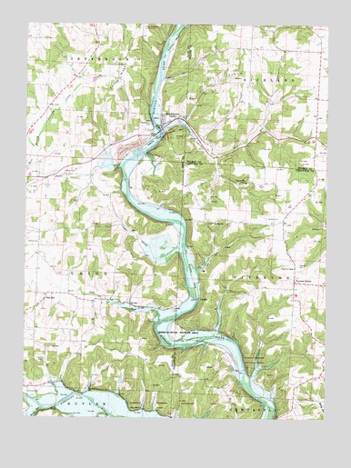
Brinkhaven, OH USGS Topographic Map
Click on map above to begin viewing in our Map Viewer.

This topographic map contains these locations and features:
Feature Name Type Latitude Longitude GNIS ID View Map
Baddow Pass (historical)Populated PlaceN40.4945°W82.1479°1057281View Map
Baddow Pass Post Office (historical)Post OfficeN40.4945°W82.1485°2013562View Map
Bald Hill School (historical)SchoolN40.4176°W82.1674°1050279View Map
Borden CemeteryCemeteryN40.4384°W82.1445°1038202View Map
BrinkhavenPopulated PlaceN40.4695°W82.1940°1085454View Map
Brinkhaven CemeteryCemeteryN40.4687°W82.1982°1038322View Map
Brinkhaven Post OfficePost OfficeN40.4695°W82.1943°2021061View Map
Brush RunStreamN40.3778°W82.2418°1038426View Map
Camp Mohaven Landing Strip (historical)AirportN40.4987°W82.2013°1074895View Map
CavalloPopulated PlaceN40.4128°W82.1777°1060931View Map
Church of ChristChurchN40.4228°W82.1382°1039105View Map
City of GannCivilN40.4684°W82.1935°1085660View Map
Elm Farm (historical)LocaleN40.4612°W82.2346°1069204View Map
Flat RunStreamN40.4042°W82.1957°1040509View Map
Flat Run School (historical)SchoolN40.4131°W82.2152°1052004View Map
Hollister CemeteryCemeteryN40.3833°W82.2484°1041669View Map
Hollisters (historical)Populated PlaceN40.3834°W82.2485°1070382View Map
House School (historical)SchoolN40.4892°W82.1577°1056053View Map
Hunter School (historical)SchoolN40.4417°W82.1763°1050278View Map
Jelloway Valley Farm (historical)LocaleN40.4473°W82.2388°1069209View Map
McKee CemeteryCemeteryN40.4307°W82.2445°1961267View Map
Mohican River Wildlife AreaParkN40.4651°W82.1899°1057851View Map
Negro RunStreamN40.4656°W82.1940°1043794View Map
Negro Run School (historical)SchoolN40.4623°W82.1571°1056071View Map
Oak HillPopulated PlaceN40.4142°W82.2410°1062921View Map
Oakhill School (historical)SchoolN40.4098°W82.2457°1052003View Map
Pilgrim Hills CampLocaleN40.4498°W82.1585°1044449View Map
Pleasant Valley School (historical)SchoolN40.4492°W82.2221°1052006View Map
Riley CemeteryCemeteryN40.3789°W82.2008°1961277View Map
Riley ChapelChurchN40.3781°W82.2010°1045023View Map
School Number 2 (historical)SchoolN40.4840°W82.2213°1069225View Map
School Number 7 (historical)SchoolN40.3834°W82.2227°1069238View Map
Seven Spring Farm (historical)LocaleN40.4028°W82.2218°1069241View Map
Spoon RiverStreamN40.3853°W82.1561°2127018View Map
Tager ValleyValleyN40.4287°W82.1874°1068225View Map
Tager Valley School (historical)SchoolN40.4337°W82.2040°1052005View Map
Tiverton Baptist CemeteryCemeteryN40.4369°W82.1717°1964141View Map
Tiverton CemeteryCemeteryN40.4239°W82.1371°1047074View Map
Tiverton CenterPopulated PlaceN40.4181°W82.1382°1061695View Map
Tiverton ChurchChurchN40.4367°W82.1721°1047075View Map
Tiverton Post Office (historical)Post OfficeN40.4181°W82.1388°1967454View Map
Township of TivertonCivilN40.4179°W82.1370°1085927View Map
Township of UnionCivilN40.4286°W82.2331°1086413View Map
Turkey RidgeRidgeN40.4826°W82.2102°1047198View Map
Turkey Ridge School (historical)SchoolN40.4840°W82.2202°1052007View Map
Umbria (historical)Populated PlaceN40.4001°W82.1902°1067428View Map
Village of GannCivilN40.4692°W82.1913°2398942View Map
Yankee RidgeRidgeN40.4256°W82.1397°2127075View Map
ZuckPopulated PlaceN40.3781°W82.2363°1063110View Map
Zuck Post Office (historical)Post OfficeN40.3778°W82.2363°2015950View Map

Note: Coordinates in the location and feature list above are referenced to NAD83 datum.


Copyright (C) 2008-2024 Ryan Niemi / Sunset Dynamics ... All Rights Reserved