TopoQuest Logo
Do you find TopoQuest useful?
Help keep TopoQuest running and adding new maps/features by donating!
Bitcoin:  19c7KJd3qBynnjoSw5npx9KScwjBe4ifkT
Litecoin:  LXs6TkuXGGXo1vDsWCkWVdjQX94eUKd6ui
Home View Maps Find Maps Find Places Resources & Links


Tatumville, Tennessee Topographic Map

USGS Map Title: Tatumville, TN
USGS Map MRC: 36089A2
DRG (GeoTIFF) Download: o36089a2.tif


Neighboring USGS Topographic Map Quads:


  Lane, TN  
36089B3
 

  Trimble, TN  
36089B2
 

  Kenton, TN  
36089B1
 

  Newbern, TN  
36089A3
 

  Tatumville, TN  
36089A2
 

  Yorkville, TN  
36089A1
 

  Bonicord, TN  
35089H3
 

  Friendship, TN  
35089H2
 

  Brazil, TN  
35089H1


Map MRC Location:

N37°
W90°
N37°
W89°
H8 H7 H6 H5 H4 H3 H2 H1
G8 G7 G6 G5 G4 G3 G2 G1
F8 F7 F6 F5 F4 F3 F2 F1
E8 E7 E6 E5 E4 E3 E2 E1
D8 D7 D6 D5 D4 D3 D2 D1
C8 C7 C6 C5 C4 C3 C2 C1
B8 B7 B6 B5 B4 B3 B2 B1
A8 A7 A6 A5 A4 A3 A2 A1
N36°
W90°
N36°
W89°

Tatumville, TN USGS 1:24K Topographic Map Preview:
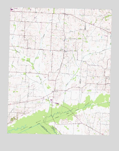
Tatumville, TN USGS Topographic Map
Click on map above to begin viewing in our Map Viewer.

This topographic map contains these locations and features:
Feature Name Type Latitude Longitude GNIS ID View Map
Arratt Chapel (historical)ChurchN36.0931°W89.2276°1316124View Map
Atkins CemeteryCemeteryN36.1020°W89.2331°1304892View Map
Bethel BranchStreamN36.0181°W89.1853°1305122View Map
Center CemeteryCemeteryN36.0834°W89.1856°1643391View Map
ChurchtonPopulated PlaceN36.1192°W89.1776°1280553View Map
College Hill School (historical)SchoolN36.0023°W89.1376°1322078View Map
Commissioner District 3CivilN36.0504°W89.2013°2464140View Map
District 8 (historical)CivilN36.0403°W89.2084°1310262View Map
Doakville CreekStreamN36.0120°W89.2059°1303437View Map
East Dyer County Volunteer Fire DepartmentBuildingN36.0432°W89.1931°2653905View Map
EdgewoodPopulated PlaceN36.0842°W89.2276°1315004View Map
Edgewood School (historical)SchoolN36.0862°W89.2273°1316127View Map
Forks of the RiverPopulated PlaceN36.0120°W89.1590°1312579View Map
Halls ChapelChurchN36.0715°W89.1751°1647226View Map
Harris CreekStreamN36.0684°W89.2203°1286978View Map
LapataPopulated PlaceN36.0828°W89.1823°1315354View Map
Lemalsamac ChurchChurchN36.1198°W89.1823°1291010View Map
Lisbon School (historical)SchoolN36.0906°W89.1820°1316131View Map
Macedonia BottomBasinN36.0245°W89.1628°1292398View Map
Mayfield ChurchChurchN36.0112°W89.1640°1293012View Map
Middle Fork Forked Deer RiverStreamN36.0101°W89.2109°1293673View Map
Mount Olive ChurchChurchN36.1184°W89.1617°1294709View Map
Mount Tirzah ChurchChurchN36.0540°W89.1912°1294811View Map
NebovillePopulated PlaceN36.0567°W89.1303°1295294View Map
Neboville School (historical)SchoolN36.0565°W89.1301°1322177View Map
PotatoePopulated PlaceN36.1209°W89.2351°1309845View Map
Shaw CemeteryCemeteryN36.0437°W89.1870°1643415View Map
Squirt CreekStreamN36.0331°W89.1262°1271184View Map
Summerview School (historical)SchoolN36.0112°W89.1634°1322226View Map
TatumvillePopulated PlaceN36.0426°W89.1942°1272176View Map
Tatumville BottomBasinN36.0092°W89.2215°1272177View Map
Tatumville Church (historical)ChurchN36.0531°W89.1917°1316137View Map
Tatumville School (historical)SchoolN36.0537°W89.1917°1316138View Map
The Center ChurchChurchN36.0831°W89.1845°1272376View Map
York BranchStreamN36.0862°W89.1278°1275304View Map

Note: Coordinates in the location and feature list above are referenced to NAD83 datum.


Copyright (C) 2008-2024 Ryan Niemi / Sunset Dynamics ... All Rights Reserved