TopoQuest Logo
Do you find TopoQuest useful?
Help keep TopoQuest running and adding new maps/features by donating!
Bitcoin:  19c7KJd3qBynnjoSw5npx9KScwjBe4ifkT
Litecoin:  LXs6TkuXGGXo1vDsWCkWVdjQX94eUKd6ui
Home View Maps Find Maps Find Places Resources & Links


West Leyden, New York Topographic Map

USGS Map Title: West Leyden, NY
USGS Map MRC: 43075D4
DRG (GeoTIFF) Download: o43075d4.tif


Neighboring USGS Topographic Map Quads:


  High Market, NY  
43075E5
 

  Constableville, NY  
43075E4
 

  Port Leyden, NY  
43075E3
 

  Point Rock, NY  
43075D5
 

  West Leyden, NY  
43075D4
 

  Boonville, NY  
43075D3
 

  Lee Center, NY  
43075C5
 

  Westernville, NY  
43075C4
 

  North Western, NY  
43075C3


Map MRC Location:

N44°
W76°
N44°
W75°
H8 H7 H6 H5 H4 H3 H2 H1
G8 G7 G6 G5 G4 G3 G2 G1
F8 F7 F6 F5 F4 F3 F2 F1
E8 E7 E6 E5 E4 E3 E2 E1
D8 D7 D6 D5 D4 D3 D2 D1
C8 C7 C6 C5 C4 C3 C2 C1
B8 B7 B6 B5 B4 B3 B2 B1
A8 A7 A6 A5 A4 A3 A2 A1
N43°
W76°
N43°
W75°

West Leyden, NY USGS 1:24K Topographic Map Preview:
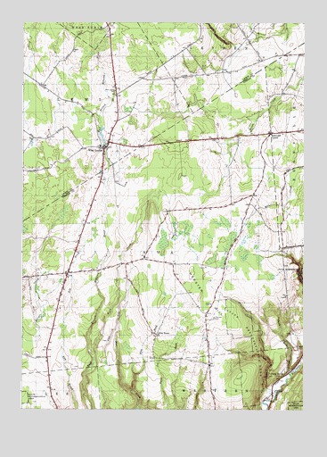
West Leyden, NY USGS Topographic Map
Click on map above to begin viewing in our Map Viewer.

This topographic map contains these locations and features:
Feature Name Type Latitude Longitude GNIS ID View Map
Alger School (historical)SchoolN43.4897°W75.3775°2357052View Map
AvaPopulated PlaceN43.4190°W75.4793°942720View Map
Bates School (historical)SchoolN43.3914°W75.4889°2357053View Map
Blue BrookStreamN43.3751°W75.4474°944299View Map
Chase CreekStreamN43.3792°W75.3877°946429View Map
Dunn BrookPopulated PlaceN43.3873°W75.3816°972398View Map
Dunn BrookStreamN43.3862°W75.3807°948809View Map
Evans School (historical)SchoolN43.4239°W75.4456°2357054View Map
Flint BrookStreamN43.3806°W75.4505°950285View Map
Flint TownPopulated PlaceN43.3995°W75.4402°972483View Map
Pasadena School (historical)SchoolN43.4842°W75.4117°2357055View Map
Redmond CornerPopulated PlaceN43.4645°W75.3899°972993View Map
Saint Mary's Nativity ChurchChurchN43.4606°W75.4625°2680215View Map
School Number 6 (historical)SchoolN43.3919°W75.4411°2357056View Map
Thornton CemeteryCemeteryN43.4046°W75.4148°967444View Map
Town of AvaCivilN43.4215°W75.4525°978701View Map
Valenty Mierek AirportAirportN43.3872°W75.4865°977902View Map
Webster HillSummitN43.4120°W75.4207°968988View Map
Webster Hill School (historical)SchoolN43.4203°W75.3833°2357057View Map
West LeydenPopulated PlaceN43.4595°W75.4638°970784View Map
West Leyden CemeteryCemeteryN43.4774°W75.4588°970785View Map
West Leyden Elementary SchoolSchoolN43.4600°W75.4655°2437703View Map
West Leyden Fire DepartmentBuildingN43.4588°W75.4635°2680213View Map
West Leyden Post OfficePost OfficeN43.4592°W75.4636°2680214View Map
Wood CreekStreamN43.3870°W75.4705°971599View Map

Note: Coordinates in the location and feature list above are referenced to NAD83 datum.


Copyright (C) 2008-2024 Ryan Niemi / Sunset Dynamics ... All Rights Reserved