TopoQuest Logo
Do you find TopoQuest useful?
Help keep TopoQuest running and adding new maps/features by donating!
Bitcoin:  19c7KJd3qBynnjoSw5npx9KScwjBe4ifkT
Litecoin:  LXs6TkuXGGXo1vDsWCkWVdjQX94eUKd6ui
Home View Maps Find Maps Find Places Resources & Links


Bunceton, Missouri Topographic Map

USGS Map Title: Bunceton, MO
USGS Map MRC: 38092G7
DRG (GeoTIFF) Download: o38092g7.tif


Neighboring USGS Topographic Map Quads:


  Pilot Grove North, MO  
38092H8
 

  Billingsville, MO  
38092H7
 

  Boonville, MO  
38092H6
 

  Pilot Grove South, MO  
38092G8
 

  Bunceton, MO  
38092G7
 

  Lone Elm, MO  
38092G6
 

  Otterville East, MO  
38092F8
 

  Tipton, MO  
38092F7
 

  Clarksburg, MO  
38092F6


Map MRC Location:

N39°
W93°
N39°
W92°
H8 H7 H6 H5 H4 H3 H2 H1
G8 G7 G6 G5 G4 G3 G2 G1
F8 F7 F6 F5 F4 F3 F2 F1
E8 E7 E6 E5 E4 E3 E2 E1
D8 D7 D6 D5 D4 D3 D2 D1
C8 C7 C6 C5 C4 C3 C2 C1
B8 B7 B6 B5 B4 B3 B2 B1
A8 A7 A6 A5 A4 A3 A2 A1
N38°
W93°
N38°
W92°

Bunceton, MO USGS 1:24K Topographic Map Preview:
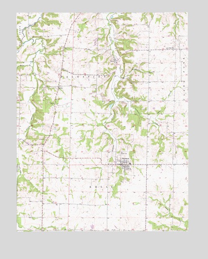
Bunceton, MO USGS Topographic Map
Click on map above to begin viewing in our Map Viewer.

This topographic map contains these locations and features:
Feature Name Type Latitude Longitude GNIS ID View Map
Baslee BranchStreamN38.8442°W92.8635°713717View Map
BellairPopulated PlaceN38.8331°W92.8444°740665View Map
Bellair School (historical)SchoolN38.8328°W92.8596°743961View Map
Bethlehem School (historical)SchoolN38.7511°W92.8599°743860View Map
Briscoe CemeteryCemeteryN38.8025°W92.8538°714715View Map
BuncetonPopulated PlaceN38.7881°W92.7994°715036View Map
Bunceton City Fire DepartmentBuildingN38.7880°W92.7944°2620492View Map
Bunceton Elementary SchoolSchoolN38.7889°W92.7920°2571133View Map
Bunceton High SchoolSchoolN38.7888°W92.7924°2571134View Map
Bunceton Police DepartmentBuildingN38.7879°W92.7990°2752409View Map
Bunceton Post OfficePost OfficeN38.7883°W92.8000°2782954View Map
City of BuncetonCivilN38.7894°W92.7991°2393461View Map
Coalbank CreekStreamN38.8259°W92.8005°716040View Map
Concord CemeteryCemeteryN38.8201°W92.7803°716172View Map
Coon CreekStreamN38.8575°W92.8699°716254View Map
Cooper CountyCivilN38.8435°W92.8101°758481View Map
Franklin School (historical)SchoolN38.7584°W92.8088°743859View Map
Gartners BranchStreamN38.8744°W92.8077°738700View Map
Hutchison BranchStreamN38.8370°W92.7988°729325View Map
Independence School (historical)SchoolN38.8742°W92.8144°743857View Map
Lone Elm School (historical)SchoolN38.8439°W92.7546°743962View Map
Lone Elm School (historical)SchoolN38.8545°W92.7605°721446View Map
Masonic CemeteryCemeteryN38.7947°W92.8002°742763View Map
Palestine School (historical)SchoolN38.8322°W92.8085°743858View Map
Petersburg (historical)Populated PlaceN38.8011°W92.8024°740036View Map
SpeedPopulated PlaceN38.8481°W92.8032°726840View Map
Township of PalestineCivilN38.8413°W92.8357°766535View Map
Tutt BranchStreamN38.8142°W92.7785°727918View Map
West Central Loess HillsAreaN38.8747°W92.7505°754094View Map

Note: Coordinates in the location and feature list above are referenced to NAD83 datum.


Copyright (C) 2008-2024 Ryan Niemi / Sunset Dynamics ... All Rights Reserved