TopoQuest Logo
Do you find TopoQuest useful?
Help keep TopoQuest running and adding new maps/features by donating!
Bitcoin:  19c7KJd3qBynnjoSw5npx9KScwjBe4ifkT
Litecoin:  LXs6TkuXGGXo1vDsWCkWVdjQX94eUKd6ui
Home View Maps Find Maps Find Places Resources & Links


Whitewater, Wisconsin Topographic Map

USGS Map Title: Whitewater, WI
USGS Map MRC: 42088G6
DRG (GeoTIFF) Download: o42088g6.tif


Neighboring USGS Topographic Map Quads:


  Fort Atkinson, WI  
42088H7
 

  Rome, WI  
42088H6
 

  Palmyra, WI  
42088H5
 

  Lima Center, WI  
42088G7
 

  Whitewater, WI  
42088G6
 

  Little Prairie, WI  
42088G5
 

  Avalon, WI  
42088F7
 

  Delavan, WI  
42088F6
 

  Elkhorn, WI  
42088F5


Map MRC Location:

N43°
W89°
N43°
W88°
H8 H7 H6 H5 H4 H3 H2 H1
G8 G7 G6 G5 G4 G3 G2 G1
F8 F7 F6 F5 F4 F3 F2 F1
E8 E7 E6 E5 E4 E3 E2 E1
D8 D7 D6 D5 D4 D3 D2 D1
C8 C7 C6 C5 C4 C3 C2 C1
B8 B7 B6 B5 B4 B3 B2 B1
A8 A7 A6 A5 A4 A3 A2 A1
N42°
W89°
N42°
W88°

Whitewater, WI USGS 1:24K Topographic Map Preview:
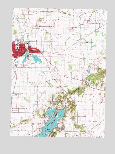
Whitewater, WI USGS Topographic Map
Click on map above to begin viewing in our Map Viewer.

This topographic map contains these locations and features:
Feature Name Type Latitude Longitude GNIS ID View Map
Andersen LibraryBuildingN42.8356°W88.7423°1851213View Map
Arey HallBuildingN42.8400°W88.7482°1851215View Map
Baker HallBuildingN42.8389°W88.7434°1851217View Map
Benson HallBuildingN42.8400°W88.7470°1851218View Map
Bigelow HallBuildingN42.8422°W88.7479°1851221View Map
Bluff CreekStreamN42.7975°W88.6957°1561976View Map
Bluff Creek State Natural AreaParkN42.7972°W88.6657°1988795View Map
Calvary CemeteryCemeteryN42.8436°W88.7436°1562533View Map
Carlson HallBuildingN42.8381°W88.7459°1851226View Map
Center of the ArtsBuildingN42.8361°W88.7465°1851228View Map
City of WhitewaterCivilN42.8371°W88.7340°1584432View Map
Clem HallBuildingN42.8417°W88.7470°1851233View Map
Clover Valley AirportAirportN42.8112°W88.7265°1582271View Map
Clover Valley Fen State Natural AreaParkN42.7861°W88.7040°1988796View Map
Congregational United Church of ChristChurchN42.8342°W88.7370°1851236View Map
Cravath LakeReservoirN42.8342°W88.7290°1563511View Map
Cravath Lake 27.5ReservoirN42.8271°W88.7316°1792067View Map
Draeger QuarryMineN42.8192°W88.7350°2633495View Map
Drumlin Dining HallBuildingN42.8408°W88.7470°1851243View Map
Esker Dining HallBuildingN42.8436°W88.7412°1840361View Map
Fairhaven Retirement HomeBuildingN42.8356°W88.7362°1851251View Map
First English Lutheran ChurchChurchN42.8345°W88.7354°1851262View Map
First United Methodist ChurchChurchN42.8336°W88.7398°1851268View Map
Fischer HallBuildingN42.8417°W88.7423°1851269View Map
Franklin Middle SchoolSchoolN42.8333°W88.7432°1562908View Map
Fricker HallBuildingN42.8408°W88.7482°1851273View Map
Goodhue HallBuildingN42.8408°W88.7426°1851278View Map
Hamilton CenterBuildingN42.8372°W88.7426°1851280View Map
Heart PrairiePopulated PlaceN42.7656°W88.6420°1566251View Map
Heart Prairie CemeteryCemeteryN42.7628°W88.6429°2002805View Map
Heart Prairie ChurchChurchN42.7567°W88.7018°1566252View Map
Heide HallBuildingN42.8372°W88.7407°1851282View Map
Hillside CemeteryCemeteryN42.8279°W88.7288°1566455View Map
Hyer HallBuildingN42.8364°W88.7434°1851284View Map
Irvin Young Memorial LibraryBuildingN42.8331°W88.7368°1851286View Map
Kettle Moraine Baptist AcademySchoolN42.8276°W88.7273°2716389View Map
Knilans HallBuildingN42.8428°W88.7401°1840396View Map
Lake La GrangeReservoirN42.8142°W88.6470°1567679View Map
Lakeview Elementary SchoolSchoolN42.7576°W88.7116°1567801View Map
Lee HallBuildingN42.8417°W88.7482°1851292View Map
Lincoln Inquiry Charter SchoolSchoolN42.8313°W88.7478°1576556View Map
Little Log CabinBuildingN42.8375°W88.7440°1851293View Map
Lyons CemeteryCemeteryN42.7514°W88.6765°1568852View Map
McCutchan HallBuildingN42.8381°W88.7451°1851300View Map
McGraw HallBuildingN42.8367°W88.7426°1851301View Map
Moraine BookstoreBuildingN42.8403°W88.7426°1851304View Map
Norwegian Evangelical Lutheran Heart Prairie Church CemeteryCemeteryN42.7564°W88.7018°2002807View Map
Oak Grove CemeteryCemeteryN42.8345°W88.7233°1570609View Map
Old Paper Mill DamDamN42.8300°W88.7251°1792064View Map
Old Stone Mill 3SE470 DamDamN42.8333°W88.7301°1792066View Map
Perkins StadiumLocaleN42.8470°W88.7451°1840415View Map
Rice LakeLakeN42.7739°W88.6970°1572253View Map
Rice LakeReservoirN42.7723°W88.6966°1793173View Map
Rice Lake DamDamN42.7783°W88.6984°1793172View Map
Roseman HallBuildingN42.8383°W88.7423°1851317View Map
Saint Johns Lutheran ChurchChurchN42.8345°W88.7370°1851325View Map
Saint Lukes Episcopal ChurchChurchN42.8333°W88.7370°1851326View Map
Salisbury HallBuildingN42.8392°W88.7440°1851331View Map
Sayles HallBuildingN42.8395°W88.7434°1851332View Map
Spring BrookStreamN42.8325°W88.7293°1574597View Map
Starin ParkParkN42.8411°W88.7379°1574813View Map
Town of WhitewaterCivilN42.7923°W88.7158°1584433View Map
Tripp LakeReservoirN42.8295°W88.7251°1575655View Map
Tripp Lake 12.0ReservoirN42.8256°W88.7173°1792065View Map
Trippe Lake ParkParkN42.8286°W88.7237°1851341View Map
Tutt HallBuildingN42.8436°W88.7401°1840454View Map
University CenterBuildingN42.8381°W88.7434°1851343View Map
University Lutheran ChurchChurchN42.8383°W88.7473°1851344View Map
University of Wisconsin - WhitewaterSchoolN42.8379°W88.7418°1576913View Map
University of Wisconsin - Whitewater Police StationBuildingN42.8409°W88.7425°2759879View Map
Upham HallBuildingN42.8395°W88.7426°1851345View Map
Veterans Memorial BuildingBuildingN42.8311°W88.7273°1851346View Map
Washington Elementary SchoolSchoolN42.8343°W88.7223°1564379View Map
Wellers HallBuildingN42.8436°W88.7395°1840466View Map
Wells Residence HallBuildingN42.8431°W88.7387°1840467View Map
White HallBuildingN42.8395°W88.7451°1851358View Map
WhitewaterPopulated PlaceN42.8336°W88.7323°1576690View Map
Whitewater Baptist ChurchChurchN42.8275°W88.7276°1851359View Map
Whitewater Bible ChurchChurchN42.8317°W88.7387°1851360View Map
Whitewater City HallBuildingN42.8325°W88.7334°1851361View Map
Whitewater Fire Department and Rescue SquadBuildingN42.8321°W88.7339°2697568View Map
Whitewater Historical Society MuseumBuildingN42.8317°W88.7334°1851363View Map
Whitewater LakeLakeN42.7653°W88.6948°1576692View Map
Whitewater Lake 2-Wp-651 DamDamN42.7683°W88.6901°1792272View Map
Whitewater Lake 70ReservoirN42.7574°W88.6959°1792273View Map
Whitewater Police DepartmentBuildingN42.8322°W88.7337°2759506View Map
Whitewater Post OfficePost OfficeN42.8331°W88.7329°1851364View Map
Williams CenterBuildingN42.8436°W88.7451°1840470View Map
Winther HallBuildingN42.8383°W88.7409°1851371View Map
WSUW-FM (Whitewater)TowerN42.8361°W88.7434°1582637View Map
Young AuditoriumBuildingN42.8367°W88.7459°1851374View Map
Young Prairie State Natural AreaParkN42.8406°W88.6365°1988799View Map

Note: Coordinates in the location and feature list above are referenced to NAD83 datum.


Copyright (C) 2008-2024 Ryan Niemi / Sunset Dynamics ... All Rights Reserved