TopoQuest Logo
Do you find TopoQuest useful?
Help keep TopoQuest running and adding new maps/features by donating!
Bitcoin:  19c7KJd3qBynnjoSw5npx9KScwjBe4ifkT
Litecoin:  LXs6TkuXGGXo1vDsWCkWVdjQX94eUKd6ui
Home View Maps Find Maps Find Places Resources & Links


Winchester, Ohio Topographic Map

USGS Map Title: Winchester, OH
USGS Map MRC: 38083H6
DRG (GeoTIFF) Download: o38083h6.tif


Neighboring USGS Topographic Map Quads:


  Sardinia, OH  
39083A7
 

  Sugar Tree Ridge, OH  
39083A6
 

  Belfast, OH  
39083A5
 

  Ash Ridge, OH  
38083H7
 

  Winchester, OH  
38083H6
 

  Seaman, OH  
38083H5
 

  Russellville, OH  
38083G7
 

  Decatur, OH  
38083G6
 

  West Union, OH  
38083G5


Map MRC Location:

N39°
W84°
N39°
W83°
H8 H7 H6 H5 H4 H3 H2 H1
G8 G7 G6 G5 G4 G3 G2 G1
F8 F7 F6 F5 F4 F3 F2 F1
E8 E7 E6 E5 E4 E3 E2 E1
D8 D7 D6 D5 D4 D3 D2 D1
C8 C7 C6 C5 C4 C3 C2 C1
B8 B7 B6 B5 B4 B3 B2 B1
A8 A7 A6 A5 A4 A3 A2 A1
N38°
W84°
N38°
W83°

Winchester, OH USGS 1:24K Topographic Map Preview:
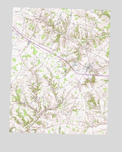
Winchester, OH USGS Topographic Map
Click on map above to begin viewing in our Map Viewer.

This topographic map contains these locations and features:
Feature Name Type Latitude Longitude GNIS ID View Map
Bennington CemeteryCemeteryN38.8987°W83.7008°1037859View Map
Carson HillSummitN38.9153°W83.6294°1048585View Map
Cross School (historical)SchoolN38.9290°W83.6255°1055834View Map
Crum Chapel School (historical)SchoolN38.9634°W83.6985°1053050View Map
Eugene School (historical)SchoolN38.8884°W83.6466°1055838View Map
FincastlePopulated PlaceN38.9917°W83.7146°1064651View Map
Fincastle Baptist ChurchChurchN38.9895°W83.7157°2634435View Map
Fincastle CemeteryCemeteryN38.9992°W83.7116°1040437View Map
Fulton School (historical)SchoolN38.9134°W83.7080°1053066View Map
Harpers Ferry School (historical)SchoolN38.9203°W83.6702°1055852View Map
Horner CemeteryCemeteryN38.9745°W83.6346°1041796View Map
Independence CemeteryCemeteryN38.9281°W83.7138°1041932View Map
Kansan School (historical)SchoolN38.9209°W83.7302°1053085View Map
Kennedy School (historical)SchoolN38.8806°W83.7071°1053086View Map
MaconPopulated PlaceN38.9651°W83.7283°1042873View Map
Macon Post OfficePost OfficeN38.9653°W83.7277°1965576View Map
Memorial ParkParkN38.9390°W83.6577°1699113View Map
Mount Olivet ChurchChurchN38.8990°W83.7033°1043593View Map
Pleasant Hill CemeteryCemeteryN38.9187°W83.6952°1044538View Map
Pleasant Hill Christian Church (historical)ChurchN38.9178°W83.6935°1730791View Map
Rickey CemeteryCemeteryN38.8915°W83.7166°1044992View Map
School Number 6 (historical)SchoolN38.9345°W83.7052°1053124View Map
Township of EagleCivilN38.9865°W83.7253°1085794View Map
Township of JacksonCivilN38.9128°W83.7299°1085798View Map
Township of WinchesterCivilN38.9619°W83.6400°1085688View Map
Turkey RunStreamN38.9667°W83.6616°1047202View Map
Upper Brush Creek School (historical)SchoolN38.9676°W83.6535°1071022View Map
Village of WinchesterCivilN38.9436°W83.6540°2399711View Map
Wallace CemeteryCemeteryN38.9653°W83.6527°1047511View Map
Waters CemeteryCemeteryN38.9251°W83.7127°1047613View Map
Wilson CemeteryCemeteryN38.9856°W83.6902°1047973View Map
Wilson School (historical)SchoolN38.9951°W83.6877°1077363View Map
WinchesterPopulated PlaceN38.9417°W83.6508°1049334View Map
Winchester - Wayne Township Life SquadBuildingN38.9424°W83.6513°2550964View Map
Winchester CemeteryCemeteryN38.9384°W83.6477°1699114View Map
Winchester Community Fire DistrictBuildingN38.9428°W83.6511°2550210View Map
Winchester Elementary SchoolSchoolN38.9417°W83.6533°1055945View Map
Winchester LakeReservoirN38.9452°W83.6689°1078068View Map
Winchester Lake DamDamN38.9467°W83.6683°1078067View Map
Winchester Post OfficePost OfficeN38.9528°W83.6371°1956287View Map

Note: Coordinates in the location and feature list above are referenced to NAD83 datum.


Copyright (C) 2008-2024 Ryan Niemi / Sunset Dynamics ... All Rights Reserved