TopoQuest Logo
Do you find TopoQuest useful?
Help keep TopoQuest running and adding new maps/features by donating!
Bitcoin:  19c7KJd3qBynnjoSw5npx9KScwjBe4ifkT
Litecoin:  LXs6TkuXGGXo1vDsWCkWVdjQX94eUKd6ui
Home View Maps Find Maps Find Places Resources & Links


Windsor, South Carolina Topographic Map

USGS Map Title: Windsor, SC
USGS Map MRC: 33081D5
DRG (GeoTIFF) Download: o33081d5.tif


Neighboring USGS Topographic Map Quads:


  Aiken, SC  
33081E6
 

  Oakwood, SC  
33081E5
 

  Kitchings Mill, SC  
33081E4
 

  New Ellenton, SC  
33081D6
 

  Windsor, SC  
33081D5
 

  Williston, SC  
33081D4
 

  New Ellenton SW, SC  
33081C6
 

  New Ellenton SE, SC  
33081C5
 

  Long Branch, SC  
33081C4


Map MRC Location:

N34°
W82°
N34°
W81°
H8 H7 H6 H5 H4 H3 H2 H1
G8 G7 G6 G5 G4 G3 G2 G1
F8 F7 F6 F5 F4 F3 F2 F1
E8 E7 E6 E5 E4 E3 E2 E1
D8 D7 D6 D5 D4 D3 D2 D1
C8 C7 C6 C5 C4 C3 C2 C1
B8 B7 B6 B5 B4 B3 B2 B1
A8 A7 A6 A5 A4 A3 A2 A1
N33°
W82°
N33°
W81°

Windsor, SC USGS 1:24K Topographic Map Preview:
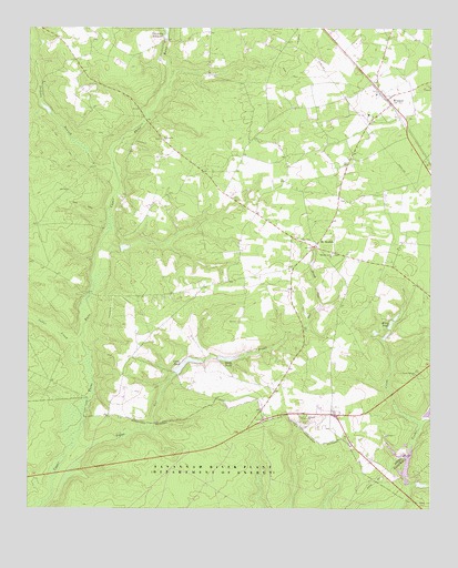
Windsor, SC USGS Topographic Map
Click on map above to begin viewing in our Map Viewer.

This topographic map contains these locations and features:
Feature Name Type Latitude Longitude GNIS ID View Map
Beulah ForkStreamN33.4282°W81.5340°1220644View Map
Beulah Grove ChurchChurchN33.4415°W81.5304°1246861View Map
Beulah Grove School (historical)SchoolN33.4421°W81.5301°1236242View Map
Boggy GutStreamN33.3910°W81.6104°1220866View Map
Cedar CreekStreamN33.4188°W81.6082°1221434View Map
Cooks PondReservoirN33.4137°W81.5753°1221730View Map
Dicks PondReservoirN33.4142°W81.5629°1222018View Map
First Baptist Church of WindsorChurchN33.4829°W81.5168°1236324View Map
Gum Ridge School (historical)SchoolN33.4243°W81.5398°1236354View Map
Hickory Grove School (historical)SchoolN33.3971°W81.5840°1236367View Map
Hillcrest ChurchChurchN33.3993°W81.5379°1245990View Map
Jackson BranchStreamN33.4635°W81.5979°1223494View Map
Johnson ForkStreamN33.3821°W81.6221°1223610View Map
Mixon Pond Dam D-3051DamN33.3851°W81.5082°1239741View Map
Mount BeulahPopulated PlaceN33.4435°W81.5362°1224683View Map
Mount Beulah Baptist ChurchChurchN33.4432°W81.5354°1236443View Map
Mount Beulah School (historical)SchoolN33.4432°W81.5365°1236444View Map
Old Rosemary Baptist ChurchChurchN33.4710°W81.5834°1250470View Map
Riley PondLakeN33.4231°W81.5122°1225887View Map
Rosemary School (historical)SchoolN33.4707°W81.5832°1236502View Map
South Carolina Noname 02053 DamDamN33.3951°W81.5082°1238011View Map
South Carolina Noname 02083 D-2020 DamDamN33.4146°W81.5657°1238038View Map
South Carolina Noname 02084 D-2040 DamDamN33.4101°W81.5782°1238040View Map
Stringfellow Mill PondReservoirN33.3870°W81.5068°1239742View Map
Stringfellows Mill (historical)LocaleN33.3835°W81.5068°1235556View Map
Town of WindsorCivilN33.4812°W81.5129°2406898View Map
Union Branch ChurchChurchN33.4101°W81.5043°1227282View Map
WAAW-FM (Williston)TowerN33.4760°W81.5490°1252558View Map
WindsorPopulated PlaceN33.4818°W81.5137°1227647View Map
Windsor DivisionCivilN33.4835°W81.5181°1938469View Map
Windsor Elementary SchoolSchoolN33.4776°W81.5193°1236592View Map
Windsor Fire - Rescue DepartmentBuildingN33.4772°W81.5073°2578470View Map
Wolfpit School (historical)SchoolN33.3993°W81.5326°1236595View Map

Note: Coordinates in the location and feature list above are referenced to NAD83 datum.


Copyright (C) 2008-2025 Ryan Niemi / Sunset Dynamics ... All Rights Reserved