TopoQuest Logo
Do you find TopoQuest useful?
Help keep TopoQuest running and adding new maps/features by donating!
Bitcoin:  19c7KJd3qBynnjoSw5npx9KScwjBe4ifkT
Litecoin:  LXs6TkuXGGXo1vDsWCkWVdjQX94eUKd6ui
Home View Maps Find Maps Find Places Resources & Links


Williston, South Carolina Topographic Map

USGS Map Title: Williston, SC
USGS Map MRC: 33081D4
DRG (GeoTIFF) Download: o33081d4.tif


Neighboring USGS Topographic Map Quads:


  Oakwood, SC  
33081E5
 

  Kitchings Mill, SC  
33081E4
 

  Salley, SC  
33081E3
 

  Windsor, SC  
33081D5
 

  Williston, SC  
33081D4
 

  Springfield, SC  
33081D3
 

  New Ellenton SE, SC  
33081C5
 

  Long Branch, SC  
33081C4
 

  Blackville, SC  
33081C3


Map MRC Location:

N34°
W82°
N34°
W81°
H8 H7 H6 H5 H4 H3 H2 H1
G8 G7 G6 G5 G4 G3 G2 G1
F8 F7 F6 F5 F4 F3 F2 F1
E8 E7 E6 E5 E4 E3 E2 E1
D8 D7 D6 D5 D4 D3 D2 D1
C8 C7 C6 C5 C4 C3 C2 C1
B8 B7 B6 B5 B4 B3 B2 B1
A8 A7 A6 A5 A4 A3 A2 A1
N33°
W82°
N33°
W81°

Williston, SC USGS 1:24K Topographic Map Preview:
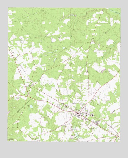
Williston, SC USGS Topographic Map
Click on map above to begin viewing in our Map Viewer.

This topographic map contains these locations and features:
Feature Name Type Latitude Longitude GNIS ID View Map
Blessed Home School (historical)SchoolN33.4826°W81.3809°1235431View Map
Bonnett Mill (historical)LocaleN33.4735°W81.4621°1236246View Map
Bonnetts Mill Pond (historical)ReservoirN33.4738°W81.4626°1236247View Map
Buzzard BranchStreamN33.4599°W81.4423°1221172View Map
Canaan Fair ChurchChurchN33.4107°W81.4240°1221296View Map
Church of GodChurchN33.3963°W81.4154°1235449View Map
Ditch PondSwampN33.4188°W81.4667°1222033View Map
Ebenezer Baptist ChurchChurchN33.3751°W81.4632°1247611View Map
Edisto ChurchChurchN33.4690°W81.4051°1222236View Map
Edisto School (historical)SchoolN33.4699°W81.4051°1236310View Map
Edwards Junior High SchoolSchoolN33.3996°W81.4054°1247643View Map
ElkoPopulated PlaceN33.3804°W81.3796°1247656View Map
Elko Baptist ChurchChurchN33.3790°W81.3796°1235463View Map
Elko Fire Department Station No. 3BuildingN33.3807°W81.3804°2578405View Map
Fair Branch ChurchChurchN33.4393°W81.4709°1222328View Map
First Baptist ChurchChurchN33.4029°W81.4234°1235472View Map
Folk PondLakeN33.3810°W81.4232°1222473View Map
Folks Lower Pond D-3053 DamDamN33.3801°W81.4215°1239726View Map
Folks Upper Pond Dam D-3052DamN33.3885°W81.4232°1239730View Map
Hallmans PondReservoirN33.4935°W81.4299°1237998View Map
Johnsons LakeReservoirN33.4513°W81.4477°1239172View Map
Johnsons Lake Dam D-2039DamN33.4518°W81.4448°1239171View Map
Jordan Baptist ChurchChurchN33.4479°W81.4340°1246206View Map
Jowers Pond Dam D-3048DamN33.4418°W81.3932°1239735View Map
Long BranchStreamN33.4743°W81.4307°1224115View Map
Nobel Street Baptist ChurchChurchN33.4071°W81.4132°1235518View Map
Peters School (historical)SchoolN33.4443°W81.4776°1236474View Map
Rosemary Baptist ChurchChurchN33.3776°W81.4693°1250469View Map
Rosemary School (historical)SchoolN33.3782°W81.4693°1235530View Map
Sand Hill GardensCemeteryN33.4710°W81.4065°1226328View Map
Silver Spring ChurchChurchN33.4301°W81.3993°1226624View Map
Silver Spring School (historical)SchoolN33.4307°W81.3998°1235551View Map
Sister LakeLakeN33.4078°W81.4736°1226650View Map
South Carolina Noname 02042 D-2037 DamDamN33.4935°W81.4265°1237997View Map
Spring BranchStreamN33.4940°W81.4179°1226803View Map
Spring Branch (historical)Populated PlaceN33.4557°W81.4418°1236549View Map
Spring Branch Baptist ChurchChurchN33.4890°W81.4415°1250995View Map
Spring Branch School (historical)SchoolN33.4982°W81.4607°1236550View Map
Summer Grove ChurchChurchN33.4210°W81.4857°1226958View Map
Tinkers Creek School (historical)SchoolN33.3763°W81.4729°1235563View Map
Town of ElkoCivilN33.3807°W81.3805°2406438View Map
Town of WillistonCivilN33.4018°W81.4220°2406891View Map
WAAW-FM (Williston)TowerN33.4660°W81.4687°1252559View Map
Webb Mill (historical)LocaleN33.4626°W81.4359°1236586View Map
Webb MillpondReservoirN33.4626°W81.4379°1251347View Map
Webbs Pond Dam D-2038DamN33.4629°W81.4371°1239169View Map
White PondLakeN33.4179°W81.4729°1251419View Map
White PondPopulated PlaceN33.4265°W81.4740°1227558View Map
White Pond ChurchChurchN33.4263°W81.4746°1236591View Map
Whitehead PondReservoirN33.4581°W81.4533°1239138View Map
Whitehead Pond Dam D-2036DamN33.4568°W81.4548°1239137View Map
WillistonPopulated PlaceN33.4026°W81.4201°1227623View Map
Williston DivisionCivilN33.3937°W81.3963°1938468View Map
Williston Fire DepartmentBuildingN33.4036°W81.4248°2578184View Map
Williston Police DepartmentBuildingN33.4034°W81.4245°2734294View Map
Williston Presbyterian ChurchChurchN33.4024°W81.4207°1235573View Map
Williston Rescue SquadBuildingN33.4041°W81.4235°2739536View Map
Williston-Elko High SchoolSchoolN33.3965°W81.4140°1235574View Map
Williston-Elko Middle SchoolSchoolN33.3957°W81.4129°1235575View Map
Windsor School (historical)SchoolN33.4788°W81.4982°1236593View Map
Winfield Heights Baptist ChurchChurchN33.3874°W81.4087°1251473View Map

Note: Coordinates in the location and feature list above are referenced to NAD83 datum.


Copyright (C) 2008-2025 Ryan Niemi / Sunset Dynamics ... All Rights Reserved