TopoQuest Logo
Do you find TopoQuest useful?
Help keep TopoQuest running and adding new maps/features by donating!
Bitcoin:  19c7KJd3qBynnjoSw5npx9KScwjBe4ifkT
Litecoin:  LXs6TkuXGGXo1vDsWCkWVdjQX94eUKd6ui
Home View Maps Find Maps Find Places Resources & Links


Bracewell, Colorado Topographic Map

USGS Map Title: Bracewell, CO
USGS Map MRC: 40104D7
DRG (GeoTIFF) Download: o40104d7.tif


Neighboring USGS Topographic Map Quads:


  Timnath, CO  
40104E8
 

  Severance, CO  
40104E7
 

  Eaton, CO  
40104E6
 

  Windsor, CO  
40104D8
 

  Bracewell, CO  
40104D7
 

  Greeley, CO  
40104D6
 

  Johnstown, CO  
40104C8
 

  Milliken, CO  
40104C7
 

  La Salle, CO  
40104C6


Map MRC Location:

N41°
W105°
N41°
W104°
H8 H7 H6 H5 H4 H3 H2 H1
G8 G7 G6 G5 G4 G3 G2 G1
F8 F7 F6 F5 F4 F3 F2 F1
E8 E7 E6 E5 E4 E3 E2 E1
D8 D7 D6 D5 D4 D3 D2 D1
C8 C7 C6 C5 C4 C3 C2 C1
B8 B7 B6 B5 B4 B3 B2 B1
A8 A7 A6 A5 A4 A3 A2 A1
N40°
W105°
N40°
W104°

Bracewell, CO USGS 1:24K Topographic Map Preview:
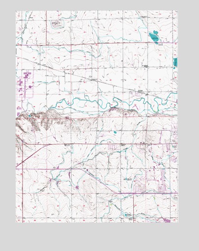
Bracewell, CO USGS Topographic Map
Click on map above to begin viewing in our Map Viewer.

This topographic map contains these locations and features:
Feature Name Type Latitude Longitude GNIS ID View Map
Antelope HillSummitN40.4922°W104.8444°180594View Map
Arrowhead ReservoirReservoirN40.3757°W104.7587°199505View Map
Ashton SchoolSchoolN40.3772°W104.7847°180584View Map
Boomerang DitchCanalN40.4008°W104.8311°180590View Map
BracewellPopulated PlaceN40.4594°W104.8172°180603View Map
BrucePopulated PlaceN40.4958°W104.8644°180593View Map
Buxman Dairy and FarmsLocaleN40.4681°W104.7861°2707043View Map
City of GreeleyCivilN40.4150°W104.7698°2410654View Map
Colorado State Patrol Troop 3A GreeleyBuildingN40.4173°W104.8600°2757339View Map
ComerPopulated PlaceN40.4678°W104.8544°180595View Map
Company DitchCanalN40.3980°W104.7858°180589View Map
Consolidated Law DitchCanalN40.4666°W104.8736°180592View Map
Erickson ReservoirReservoirN40.3795°W104.7904°180585View Map
FarmersPopulated PlaceN40.4519°W104.7791°180600View Map
Grapevine DitchCanalN40.4028°W104.7608°180587View Map
Greeley Country ClubLocaleN40.4205°W104.7527°180601View Map
Greeley Fire Department Station 5BuildingN40.4002°W104.7573°2667225View Map
Greeley Fire Department Station 7BuildingN40.4219°W104.7871°2666962View Map
Hazelton SchoolSchoolN40.4211°W104.7939°180581View Map
Highline Farm AirstripAirportN40.4712°W104.8137°2717093View Map
Hogarty ReservoirReservoirN40.4816°W104.7672°180597View Map
Jones DitchCanalN40.4403°W104.8241°180583View Map
La Grange SchoolSchoolN40.4669°W104.7730°180596View Map
Lucas SchoolLocaleN40.4961°W104.7736°180599View Map
Neff LakeLakeN40.4841°W104.7684°180598View Map
Neill Brothers ReservoirReservoirN40.4005°W104.7900°180586View Map
Neuman LakeReservoirN40.4695°W104.7512°202729View Map
North Boomerang ExtensionCanalN40.4205°W104.8130°180591View Map
Plain View SchoolLocaleN40.4214°W104.8330°180582View Map
Sheep DrawValleyN40.4411°W104.7761°180602View Map
West Grapevine DitchCanalN40.4139°W104.7700°180588View Map
Windsor DivisionCivilN40.4921°W104.8721°1935598View Map

Note: Coordinates in the location and feature list above are referenced to NAD83 datum.


Copyright (C) 2008-2025 Ryan Niemi / Sunset Dynamics ... All Rights Reserved