TopoQuest Logo
Do you find TopoQuest useful?
Help keep TopoQuest running and adding new maps/features by donating!
Bitcoin:  19c7KJd3qBynnjoSw5npx9KScwjBe4ifkT
Litecoin:  LXs6TkuXGGXo1vDsWCkWVdjQX94eUKd6ui
Home View Maps Find Maps Find Places Resources & Links


Brussels, Wisconsin Topographic Map

USGS Map Title: Brussels, WI
USGS Map MRC: 44087F5
DRG (GeoTIFF) Download: o44087f5.tif


Neighboring USGS Topographic Map Quads:


  Little Sturgeon SW, WI  
44087G6
 

  Little Sturgeon, WI  
44087G5
 

  Sturgeon Bay West, WI  
44087G4
 

  Namur, WI  
44087F6
 

  Brussels, WI  
44087F5
 

  Forestville, WI  
44087F4
 

  Luxemburg, WI  
44087E6
 

  Casco, WI  
44087E5
 

  Algoma, WI  
44087E4


Map MRC Location:

N45°
W88°
N45°
W87°
H8 H7 H6 H5 H4 H3 H2 H1
G8 G7 G6 G5 G4 G3 G2 G1
F8 F7 F6 F5 F4 F3 F2 F1
E8 E7 E6 E5 E4 E3 E2 E1
D8 D7 D6 D5 D4 D3 D2 D1
C8 C7 C6 C5 C4 C3 C2 C1
B8 B7 B6 B5 B4 B3 B2 B1
A8 A7 A6 A5 A4 A3 A2 A1
N44°
W88°
N44°
W87°

Brussels, WI USGS 1:24K Topographic Map Preview:
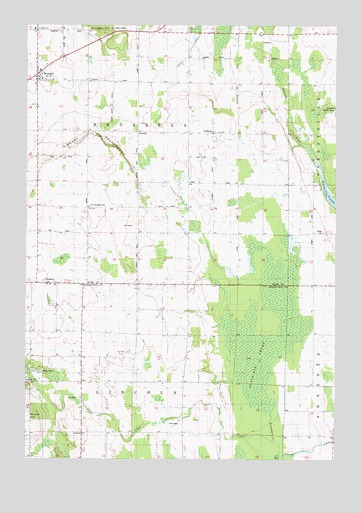
Brussels, WI USGS Topographic Map
Click on map above to begin viewing in our Map Viewer.

This topographic map contains these locations and features:
Feature Name Type Latitude Longitude GNIS ID View Map
Ahnapee River Tree FarmLocaleN44.7269°W87.5222°2710631View Map
Ahnapee State TrailTrailN44.7264°W87.5004°1560714View Map
Black Ash SwampSwampN44.6539°W87.5315°1561838View Map
Bruemmer CreekStreamN44.6306°W87.5251°1562288View Map
BrusselsPopulated PlaceN44.7361°W87.6209°1562313View Map
Brussels - Union - Gardner Fire Department Station 1BuildingN44.7358°W87.6196°2697832View Map
Brussels Post OfficePost OfficeN44.7364°W87.6193°2710580View Map
C and M FarmsLocaleN44.6600°W87.6242°2710494View Map
Dhuey HillSummitN44.6378°W87.6243°1563959View Map
Doorco FarmsLocaleN44.7264°W87.6189°2710634View Map
Emergency Services of Door CountyBuildingN44.7358°W87.6197°2698312View Map
Engebose FarmsLocaleN44.7058°W87.5747°2710630View Map
Fair Land DairyLocaleN44.7186°W87.5814°2710637View Map
Forestville Flowage 40ReservoirN44.6989°W87.5007°1792149View Map
Gregor School (historical)SchoolN44.6331°W87.5618°1840638View Map
KolbergPopulated PlaceN44.7192°W87.5490°1567608View Map
Lincoln School (historical)SchoolN44.6753°W87.5704°1840655View Map
Marin FarmsLocaleN44.7456°W87.5211°2711202View Map
Niagara EscarpmentCliffN44.7181°W87.5951°1570273View Map
Orchard View Game FarmLocaleN44.7456°W87.5814°2710638View Map
Rio CreekStreamN44.6264°W87.5223°1572332View Map
Roosevelt School (historical)SchoolN44.6972°W87.6098°1838068View Map
RosierePopulated PlaceN44.6756°W87.6120°1572620View Map
Rosiere School (historical)SchoolN44.6619°W87.6134°1840669View Map
Saint Hubert Catholic ChurchChurchN44.6753°W87.6134°1840675View Map
Saint Huberts Catholic CemeteryCemeteryN44.6750°W87.6127°1840676View Map
Saint Michaels CemeteryCemeteryN44.6982°W87.5988°1573379View Map
Saint Michaels Church (historical)ChurchN44.6978°W87.5998°1838072View Map
Springdale Dairy FarmLocaleN44.6458°W87.6042°2710492View Map
Town of BrusselsCivilN44.7191°W87.5804°1582880View Map
Town of LincolnCivilN44.6323°W87.5811°1583566View Map
Woller CemeteryCemeteryN44.6904°W87.5054°1576953View Map
WOMA-FM (Algoma)TowerN44.6572°W87.5626°1582579View Map

Note: Coordinates in the location and feature list above are referenced to NAD83 datum.


Copyright (C) 2008-2025 Ryan Niemi / Sunset Dynamics ... All Rights Reserved