TopoQuest Logo
Do you find TopoQuest useful?
Help keep TopoQuest running and adding new maps/features by donating!
Bitcoin:  19c7KJd3qBynnjoSw5npx9KScwjBe4ifkT
Litecoin:  LXs6TkuXGGXo1vDsWCkWVdjQX94eUKd6ui
Home View Maps Find Maps Find Places Resources & Links


Bryant, Wisconsin Topographic Map

USGS Map Title: Bryant, WI
USGS Map MRC: 45089B1
DRG (GeoTIFF) Download: o45089b1.tif


Neighboring USGS Topographic Map Quads:


  Kempster, WI  
45089C2
 

  Pearson, WI  
45089C1
 

  Pickerel, WI  
45088C8
 

  Antigo, WI  
45089B2
 

  Bryant, WI  
45089B1
 

  Polar, WI  
45088B8
 

  Aniwa, WI  
45089A2
 

  Mattoon, WI  
45089A1
 

  Zoar, WI  
45088A8


Map MRC Location:

N46°
W90°
N46°
W89°
H8 H7 H6 H5 H4 H3 H2 H1
G8 G7 G6 G5 G4 G3 G2 G1
F8 F7 F6 F5 F4 F3 F2 F1
E8 E7 E6 E5 E4 E3 E2 E1
D8 D7 D6 D5 D4 D3 D2 D1
C8 C7 C6 C5 C4 C3 C2 C1
B8 B7 B6 B5 B4 B3 B2 B1
A8 A7 A6 A5 A4 A3 A2 A1
N45°
W90°
N45°
W89°

Bryant, WI USGS 1:24K Topographic Map Preview:
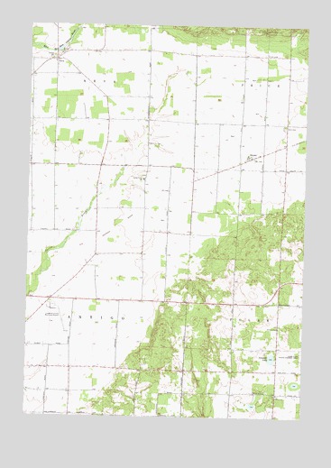
Bryant, WI USGS Topographic Map
Click on map above to begin viewing in our Map Viewer.

This topographic map contains these locations and features:
Feature Name Type Latitude Longitude GNIS ID View Map
25 ReservoirReservoirN45.1950°W89.0918°1791801View Map
Antigo Township Fire DepartmentBuildingN45.1616°W89.1137°2696936View Map
Bent CemeteryCemeteryN45.2183°W89.0093°1561576View Map
BryantPopulated PlaceN45.2080°W89.0240°1562315View Map
Edison School (historical)SchoolN45.1905°W89.0296°1840757View Map
Fairview School (historical)SchoolN45.1405°W89.1146°1840760View Map
Franklin School (historical)SchoolN45.1322°W89.0318°1840770View Map
Grandview OrchardLocaleN45.1417°W89.0511°2631413View Map
Green Valley School (historical)SchoolN45.2408°W89.0290°1840774View Map
Highland School (historical)SchoolN45.1611°W89.0187°1840775View Map
Langlade County AirportAirportN45.1533°W89.1055°1581857View Map
Neff Switch School (historical)SchoolN45.1914°W89.0740°1840790View Map
NevaPopulated PlaceN45.2394°W89.1132°1570194View Map
Neva CemeteryCemeteryN45.2422°W89.1076°1840791View Map
Polar TownhallBuildingN45.1611°W89.0187°1840797View Map
Saint Johns ChurchChurchN45.1539°W89.0118°1573116View Map
Saint Peters ChurchChurchN45.1322°W89.0115°1573539View Map
Schmuhl LakeLakeN45.1439°W89.0140°1573789View Map
Selenski School (historical)SchoolN45.1625°W89.0734°1840811View Map
Skinner DamDamN45.1950°W89.0918°1791800View Map
Spring Valley Elementary SchoolSchoolN45.2007°W89.0729°1574712View Map
Springbrook School (historical)SchoolN45.2200°W89.0721°1840814View Map
Town of AntigoCivilN45.1651°W89.1079°1582701View Map
Town of NevaCivilN45.2486°W89.1146°1583796View Map

Note: Coordinates in the location and feature list above are referenced to NAD83 datum.


Copyright (C) 2008-2025 Ryan Niemi / Sunset Dynamics ... All Rights Reserved