TopoQuest Logo
Do you find TopoQuest useful?
Help keep TopoQuest running and adding new maps/features by donating!
Bitcoin:  19c7KJd3qBynnjoSw5npx9KScwjBe4ifkT
Litecoin:  LXs6TkuXGGXo1vDsWCkWVdjQX94eUKd6ui
Home View Maps Find Maps Find Places Resources & Links


Bedford, Pennsylvania Topographic Map

USGS Map Title: Bedford, PA
USGS Map MRC: 40078A5
DRG (GeoTIFF) Download: o40078a5.tif


Neighboring USGS Topographic Map Quads:


  Ogletown, PA  
40078B6
 

  Alum Bank, PA  
40078B5
 

  New Enterprise, PA  
40078B4
 

  Schellsburg, PA  
40078A6
 

  Bedford, PA  
40078A5
 

  Everett West, PA  
40078A4
 

  Buffalo Mills, PA  
39078H6
 

  Rainsburg, PA  
39078H5
 

  Clearville, PA  
39078H4


Map MRC Location:

N41°
W79°
N41°
W78°
H8 H7 H6 H5 H4 H3 H2 H1
G8 G7 G6 G5 G4 G3 G2 G1
F8 F7 F6 F5 F4 F3 F2 F1
E8 E7 E6 E5 E4 E3 E2 E1
D8 D7 D6 D5 D4 D3 D2 D1
C8 C7 C6 C5 C4 C3 C2 C1
B8 B7 B6 B5 B4 B3 B2 B1
A8 A7 A6 A5 A4 A3 A2 A1
N40°
W79°
N40°
W78°

Bedford, PA USGS 1:24K Topographic Map Preview:
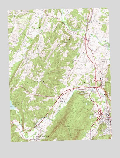
Bedford, PA USGS Topographic Map
Click on map above to begin viewing in our Map Viewer.

This topographic map contains these locations and features:
Feature Name Type Latitude Longitude GNIS ID View Map
Adams RunStreamN40.1129°W78.5567°1168065View Map
Amick SchoolSchoolN40.0629°W78.5842°1206846View Map
Anderson CemeteryCemeteryN40.0963°W78.5329°2776035View Map
BedfordPopulated PlaceN40.0187°W78.5039°1213610View Map
Bedford Area Ambulance Service - Unit 11BuildingN40.0168°W78.5069°2719505View Map
Bedford CemeteryCemeteryN40.0266°W78.5013°2776043View Map
Bedford County AirportAirportN40.0880°W78.5167°1193821View Map
Bedford County Sheriff's OfficeBuildingN40.0170°W78.5044°2777364View Map
Bedford Fire Department Station 31BuildingN40.0175°W78.5068°2645696View Map
Bedford Intermediate Elementary SchoolSchoolN40.0326°W78.5059°1207340View Map
Bedford Memorial Gardens / Bedford County Memorial ParkCemeteryN40.0553°W78.5079°1169084View Map
Bedford Police DepartmentBuildingN40.0175°W78.5068°2777365View Map
Bedford Post OfficePost OfficeN40.0173°W78.5029°2768334View Map
Bedford Primary Elementary SchoolSchoolN40.0151°W78.5039°1207341View Map
Bedford Springs Post Office (historical)Post OfficeN40.0187°W78.5039°2027120View Map
BeldenPopulated PlaceN40.0759°W78.5056°1169136View Map
Borough of BedfordCivilN40.0149°W78.5033°1214895View Map
Borough of Manns ChoiceCivilN40.0035°W78.5912°1214900View Map
Brush RunStreamN40.0898°W78.5095°1170450View Map
Buffalo RunStreamN40.0056°W78.5978°1170619View Map
Centennial School (historical)SchoolN40.0765°W78.6022°1206847View Map
CessnaPopulated PlaceN40.0945°W78.5256°1171519View Map
Christian Light Church CemeteryCemeteryN40.1039°W78.5241°2776061View Map
Claycomb Covered BridgeBridgeN40.0401°W78.5072°1954961View Map
Crossroads SchoolSchoolN40.0770°W78.5192°1206849View Map
Cumberland Valley RunStreamN40.0204°W78.5067°1192321View Map
FishertownPopulated PlaceN40.1217°W78.5856°1174832View Map
Fishertown Brethren CemeteryCemeteryN40.1225°W78.5881°2776077View Map
Fishertown CemeteryCemeteryN40.1194°W78.5895°2776078View Map
Fishertown StationLocaleN40.1179°W78.5586°1206852View Map
Harrison Manns Choice Community CenterBuildingN40.0048°W78.5931°1214526View Map
Hazlett School (historical)SchoolN40.0681°W78.5525°1206850View Map
Herline Covered BridgeBridgeN40.0165°W78.5931°1954951View Map
John C Smith DamDamN40.0334°W78.5314°1194503View Map
Kinton KnobSummitN40.0137°W78.5553°1178532View Map
Kinton Knob Fire TowerTowerN40.0137°W78.5556°1213028View Map
Manns ChoicePopulated PlaceN40.0026°W78.5911°1180282View Map
Manns Choice Post OfficePost OfficeN40.0050°W78.5894°2777407View Map
Milburn Spring DamDamN40.0067°W78.5331°1194482View Map
Milburn Spring ReservoirReservoirN40.0068°W78.5331°1194481View Map
Moore School (historical)SchoolN40.0829°W78.6156°1206848View Map
Mount Olivet CemeteryCemeteryN40.0220°W78.5770°2776116View Map
Mount Ross CemeteryCemeteryN40.0345°W78.5222°2776118View Map
Mount Smith CemeteryCemeteryN40.0701°W78.5158°2776119View Map
NapierPopulated PlaceN40.0370°W78.5584°1182161View Map
Napier ChurchChurchN40.0620°W78.5842°1182162View Map
Old Presbyterian GraveyardCemeteryN40.0152°W78.5029°2776128View Map
Oppenheimer RunStreamN40.1015°W78.5267°1183012View Map
Pennsylvania State Police Troop G Bedford StationBuildingN40.0781°W78.5220°2777318View Map
Pigeon HillsSummitN40.0626°W78.5761°1183715View Map
Pine Grove ChurchChurchN40.1245°W78.5475°1183808View Map
PointPopulated PlaceN40.0776°W78.6003°1184170View Map
Quaker ValleyBasinN40.0934°W78.5981°1193166View Map
Saint Johns ChurchChurchN40.0967°W78.5245°1186096View Map
Saint Lukes ChurchChurchN40.1187°W78.5886°1186291View Map
Saint Pauls CemeteryCemeteryN40.0849°W78.5233°1186557View Map
Saint Thomas the Apostle Catholic CemeteryCemeteryN40.0175°W78.5150°2776156View Map
Shawnee BranchStreamN40.0170°W78.6120°1209335View Map
Shawnee DamDamN40.0317°W78.6197°1194498View Map
Sloan HollowValleyN40.1014°W78.5440°1187825View Map
Sloan Hollow ChurchChurchN40.0940°W78.5536°1187826View Map
Sloan Hollow School (historical)SchoolN40.0942°W78.5500°1206851View Map
Smith ReservoirReservoirN40.0342°W78.5301°1194502View Map
SpringhopePopulated PlaceN40.1031°W78.5995°1188302View Map
StuckeyvilleLocaleN40.0423°W78.5664°1207181View Map
Todd Spring DamDamN40.0217°W78.5264°1194490View Map
Todd Spring ReservoirReservoirN40.0219°W78.5263°1194491View Map
Tulls SchoolSchoolN40.0420°W78.5978°1206845View Map
WBFD-AM (Bedford)TowerN40.0326°W78.5067°1200362View Map
WolfsburgPopulated PlaceN40.0465°W78.5297°1191709View Map
WRAX-FM (Bedford)TowerN40.0437°W78.5028°1200179View Map

Note: Coordinates in the location and feature list above are referenced to NAD83 datum.


Copyright (C) 2008-2024 Ryan Niemi / Sunset Dynamics ... All Rights Reserved