TopoQuest Logo
Do you find TopoQuest useful?
Help keep TopoQuest running and adding new maps/features by donating!
Bitcoin:  19c7KJd3qBynnjoSw5npx9KScwjBe4ifkT
Litecoin:  LXs6TkuXGGXo1vDsWCkWVdjQX94eUKd6ui
Home View Maps Find Maps Find Places Resources & Links


Bunker Hill, Missouri Topographic Map

USGS Map Title: Bunker Hill, MO
USGS Map MRC: 40092E4
DRG (GeoTIFF) Download: o40092e4.tif


Neighboring USGS Topographic Map Quads:


  West Grove, IA  
40092F5
 

  Bloomfield South, IA  
40092F4
 

  Pulaski, IA  
40092F3
 

  Lancaster, MO  
40092E5
 

  Bunker Hill, MO  
40092E4
 

  Kilwinning, MO  
40092E3
 

  Queen City, MO  
40092D5
 

  Downing NW, MO  
40092D4
 

  Downing, MO  
40092D3


Map MRC Location:

N41°
W93°
N41°
W92°
H8 H7 H6 H5 H4 H3 H2 H1
G8 G7 G6 G5 G4 G3 G2 G1
F8 F7 F6 F5 F4 F3 F2 F1
E8 E7 E6 E5 E4 E3 E2 E1
D8 D7 D6 D5 D4 D3 D2 D1
C8 C7 C6 C5 C4 C3 C2 C1
B8 B7 B6 B5 B4 B3 B2 B1
A8 A7 A6 A5 A4 A3 A2 A1
N40°
W93°
N40°
W92°

Bunker Hill, MO USGS 1:24K Topographic Map Preview:
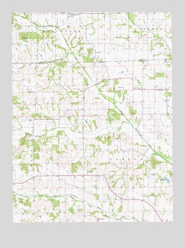
Bunker Hill, MO USGS Topographic Map
Click on map above to begin viewing in our Map Viewer.

This topographic map contains these locations and features:
Feature Name Type Latitude Longitude GNIS ID View Map
Batten BranchStreamN40.6006°W92.4538°454382View Map
Bridwell CemeteryCemeteryN40.6000°W92.4363°1976000View Map
Brush Creek School (historical)SchoolN40.5798°W92.3796°733597View Map
Bunker HillPopulated PlaceN40.5767°W92.3852°715047View Map
Darby ChurchChurchN40.5820°W92.4424°742985View Map
Del Norte Post Office (historical)Post OfficeN40.6000°W92.3946°1975999View Map
Donald Newcomb LakeReservoirN40.5550°W92.4385°760822View Map
Downing City LakeReservoirN40.5251°W92.3800°761481View Map
Downing City Lake DamDamN40.5233°W92.3779°761480View Map
Downing ReservoirReservoirN40.5251°W92.3800°738443View Map
Dutchy School (historical)SchoolN40.5334°W92.3927°733599View Map
Fabius CemeteryCemeteryN40.5223°W92.4354°2702926View Map
Fabius ChurchChurchN40.5217°W92.4355°742983View Map
Fabius School (historical)SchoolN40.5220°W92.4344°733600View Map
Gardner CemeteryCemeteryN40.5800°W92.4177°742986View Map
Howell CemeteryCemeteryN40.6100°W92.4919°457699View Map
Jaybird Darby School (historical)SchoolN40.5814°W92.4338°733596View Map
Klondike ChurchChurchN40.6017°W92.4352°458126View Map
Lancaster City LakeReservoirN40.5136°W92.3823°761852View Map
Lancaster City Lake DamDamN40.5150°W92.3819°761851View Map
LunsfordPopulated PlaceN40.6028°W92.4355°464633View Map
Lunsford Post Office (historical)Post OfficeN40.6028°W92.4355°1976048View Map
New Zion CemeteryCemeteryN40.5778°W92.4821°742984View Map
New Zion School (historical)SchoolN40.5770°W92.4816°733595View Map
Newcomb Dam - North DamDamN40.5600°W92.4419°762395View Map
Newcomb Dam - South DamDamN40.5550°W92.4385°760821View Map
Newcomb Hereford Ranch AirportAirportN40.5554°W92.4402°758776View Map
Norman LakeReservoirN40.5610°W92.4862°760820View Map
Norman Lake DamDamN40.5600°W92.4852°760819View Map
Number 521 Dam (historical)DamN40.5967°W92.4169°761478View Map
Number 524 DamDamN40.5617°W92.4252°761484View Map
Pleasant Grove ChurchChurchN40.5795°W92.4007°742987View Map
Reeves School (historical)SchoolN40.5400°W92.4307°733598View Map
SavannahPopulated PlaceN40.6242°W92.4544°461435View Map
Savannah CemeteryCemeteryN40.6209°W92.4570°461436View Map
Savannah ChurchChurchN40.6247°W92.4527°461437View Map
Savannah Post Office (historical)Post OfficeN40.6242°W92.4544°1976045View Map
Small CemeteryCemeteryN40.6247°W92.4577°461679View Map
South Fork North Fabius RiverStreamN40.5589°W92.4080°726748View Map
Township of FabiusCivilN40.5366°W92.4121°767369View Map
VinitaPopulated PlaceN40.5653°W92.3991°740168View Map
Walker Chapel CemeteryCemeteryN40.5022°W92.4343°742982View Map

Note: Coordinates in the location and feature list above are referenced to NAD83 datum.


Copyright (C) 2008-2025 Ryan Niemi / Sunset Dynamics ... All Rights Reserved